Provisional. A provisional ecological site description has undergone quality control and quality assurance review. It contains a working state and transition model and enough information to identify the ecological site.
MLRA notes
Major Land Resource Area (MLRA): 051X–High Intermountain Valleys
This MLRA encompasses the San Luis Valley in south central Colorado and the Taos Plateau and Taos alluvial fans of north central New Mexico. As part of the northern portion of the Rio Grande Rift, the MLRA consists of large, alluvium filled basins washed down from adjacent mountain ranges. The Rio Grande River flows through this MLRA, continuing its long function of carrying mountain sediment down to the basin. Cenozoic volcanism is an extensive characteristic of the MLRA where large basalt flows with volcanic hills and domes are abundant.Ancient Lake Alamosa is a large feature within the MLRA..
Classification relationships
NRCS:
Major Land Resource Area 51, High Intermountain Valleys (United States Department of Agriculture, Natural Resources Conservation Service, 2006).
USFS:
331J – Northern Rio Grande Basin M331Ic > 331Ja - San Luis Valley, 331Jb - San Luis Hills and 331C - Mogotes
EPA:
22 - Arizona/New Mexico Plateau > 22a - San Luis Shrublands and Hills ; 22b -San Luis Alluvial Flats and Wetlands ; 22c - Salt Flats; 22e - Sand Dunes and Sand Sheets and 22f -Taos Plateau (Griffith, 2006).
USGS:
Southern Rocky Mountain Province
Ecological site concept
The site has developed from alluvium derived from igneous geology. When this geology is broken down it contributes higher levels of calcium carbonate than associated sites across the Valley that have more of a mixed-geologic origin and leads to processes that form calcareous soils. Shallow calcium carbonate deposits within the calcareous soil has contributed to the development of a distinctive plant community that is dominated by the shrub, winterfat. Winterfat is the key indicator for a calcium carbonate layer within 20 inches of the soil surface.
The limy bench and mountain outwash are associated on similar landforms, but the limy bench is derived from igneous geology, and particular extrusive volcanic material that tends to break down into finer soils that are higher in pH. The mountain outwash site tends to have courser soils without the strong lime zone near the surface.
The Chico Fan site is a neighboring site, typically along the western and northwestern portions of the valley. The Chico Fan site is expressed as a greasewood-fourwing saltbush shrub community with blue grama and alkali sacaton on non-saline, moderately alkaline loam soils supporting calcium carbonates deeper in the soil profile (>20”).
Basalt Hills sites are closely associated with limy bench throughout the valley. Limy Bench sits below and along the flanks of Basalt Hills sites on broad benches and fans. (Travelers- Garita complex).
The Salt Flats sits a little lower in the valley on the basin floor. The Salt Flats site is higher in alkalinity and associated with greasewood and alkali sacaton.
The Valley Bench site occurs primarily on southeastern portion of the San Luis Valley. The major component landform is the erosional fan remnant where alluvial fans have been dissected by minor drainages leaving relict surfaces on wide, rolling summit positions.
This site is typically on broad alluvial fans, fans and fan terraces above lower valley land. Topography is nearly level to moderately rolling, with some areas forming broad plains. Slopes range from 0-15% in most places, but in a few locations can range up to 25%. Elevation ranges from 7,500 to 8.600 feet.
Table 2. Representative physiographic features
Landforms
(1) Alluvial fan (2) Fan (3) Valley side (4) Fan terrace
Runoff class
Low to medium
Flooding frequency
None
Ponding frequency
None
Elevation
7,500–8,600 ft
Slope
15%
Aspect
Aspect is not a significant factor
Climatic features
The climate that typifies the High Intermountain Valley, ranges from arid to semi-arid, and is characterized by cold winters, moderate summers, and much sunshine. Average annual precipitation ranges from 7 to 10 inches along the valley floor and throughout most of the resource area. Approximately 55 percent of the annual precipitation falls between May 1 and September 1. May and June are normally dry. Precipitation comes mostly from short duration high intensity thundershowers in July and August. Wide seasonal and yearly variations are common. The San Juan mountain range to the west and the Sangre de Cristo Mountains to the east intercept much of the precipitation causing a two-way rain shadow effect. Most major plant species initiate growth between mid May and late July, but growth may extend into September. Some cool season plants begin growth earlier and complete growth by mid June. There may be late re-growth on some of the plants.
Cold air from the encompassing mountain ranges drain into the valley and settle. This phenomena results in long cold winters and moderate summer temperatures. Mean average annual temperature ranges between 42 to 44 degrees F. July is the hottest month and January is the coldest. Summer temperatures range from highs in the upper 70’s and low 80’s and occasionally reach to the mid 90 degrees F. Summer nights are cool. Temperatures of -20 degrees F to -30 degrees F can be expected each year and are common during some winters. Average frost-free period is 90-115 days, from late May or early June to September.
Wind that often reaches high velocities are common, especially in the spring. Relative humidity is usually low. Even so, evaporation rates average lower than those of many dry regions because of the cooler climate. Snow cover is often light and is sometimes lacking through much of the winter. There is usually some snow, though, during the coldest weather.
Table 3. Representative climatic features
Frost-free period (characteristic range)
75-81 days
Freeze-free period (characteristic range)
104-107 days
Precipitation total (characteristic range)
8-10 in
Frost-free period (actual range)
74-83 days
Freeze-free period (actual range)
103-108 days
Precipitation total (actual range)
7-10 in
Frost-free period (average)
78 days
Freeze-free period (average)
106 days
Precipitation total (average)
9 in
Characteristic range
Actual range
Bar
Line
Figure 2. Monthly precipitation range
Characteristic range
Actual range
Bar
Line
Figure 3. Monthly minimum temperature range
Characteristic range
Actual range
Bar
Line
Figure 4. Monthly maximum temperature range
Bar
Line
Figure 5. Monthly average minimum and maximum temperature
Figure 6. Annual precipitation pattern
Figure 7. Annual average temperature pattern
Climate stations used
(1) CENTER 4 SSW [USC00051458], Center, CO
(2) WAVERLY 1W [USC00058860], Alamosa, CO
(3) SAN LUIS 1 S [USC00057430], San Luis, CO
Influencing water features
There are no appreciable water features, as this is an upland site. This site does not have a water table.
Soil features
Soils are highly calcareous. There is a strong lime zone at depths of about one foot or less, although some soils are lime-free at the surface. Soils are medium to light in texture, moderately permeable, and deep enough to hold much of the moisture that falls. Underlying material is cobbly & gravelly alluvium, cobbly & gravelly slope alluvium, or basalt bedrock. Andesite and rhyolite have been found to be bedrock at a few locations. Gravel and rock fragments may be plentiful through the profile. Shallow, rocky areas are associated with these soils in many places. The combination of soils and climate seems to favor winterfat. These soils are highly erodible if plant cover is destroyed or severely weakened.
Soils in this site are:
Garita gravelly loam
Garita cobbly loam
Luhon loam
Stunner loam
Table 4. Representative soil features
Parent material
(1) Alluvium–basalt (2) Slope alluvium–basalt (3) Alluvium–volcanic rock
Surface texture
(1) Cobbly, gravelly loam
(2) Loam
Family particle size
(1) Loamy-skeletal
(2) Fine-loamy
Drainage class
Well drained
Permeability class
Moderately slow to moderate
Soil depth
60 in
Surface fragment cover <=3"
23%
Surface fragment cover >3"
15%
Available water capacity (Depth not specified)
3–6 in
Calcium carbonate equivalent (Depth not specified)
30%
Electrical conductivity (Depth not specified)
2 mmhos/cm
Sodium adsorption ratio (Depth not specified)
5
Soil reaction (1:1 water) (Depth not specified)
7.4–9
Subsurface fragment volume <=3" (Depth not specified)
35%
Subsurface fragment volume >3" (Depth not specified)
35%
Ecological dynamics
The limy bench site developed under cold, dry, high intermountain valley climatic conditions with natural influence of herbivores and occasional fire. Changes will occur in the plant community due to climatic conditions and/or management actions. The calcareous nature of the soils tends to favor winterfat. High lime concentrations tie up nutrients and affects soil structure. Surface crusting is common. Under continued adverse impacts, a rapid decline in vegetative vigor, cover, and composition will occur. Erosion can be significant where plant cover is destroyed or severely weakened.
Winterfat dominates the plant community and gives the site a distinctive appearance. Fourwing saltbush is usually present. Small amounts of Greene's rabbitbrush and prickly pear are common. There may be scattered plants of hairy goldaster, fringed sage, snakeweed, rubber rabbitbrush, and yucca. Grasses are well distributed through the stand and make up nearly half the annual yield. Indian ricegrass, squirreltail, and blue grama are usually the main grasses. Western wheatgrass is common in places which receive more moisture from the surrounding landscape, and purple threeawn is usually present. Scarlet globemallow, scarlet gilia, Colorado four o'clock and other forbs are of minor importance.
As the site grades toward different chemistry, texture, or relief plant communities manifest themselves differently. Fourwing saltbush adapts better with higher pH. Winterfat can withstand higher CaCo3. Courser soils tend to bring in more sand dropseed, needleandthread and clusters of yucca and prickly pear. These physical and chemical variations create subtle gradients in plant community composition and production.
State and transition model
More interactive model formats are also available.
View Interactive Models
Click on state and transition labels to scroll to the respective text
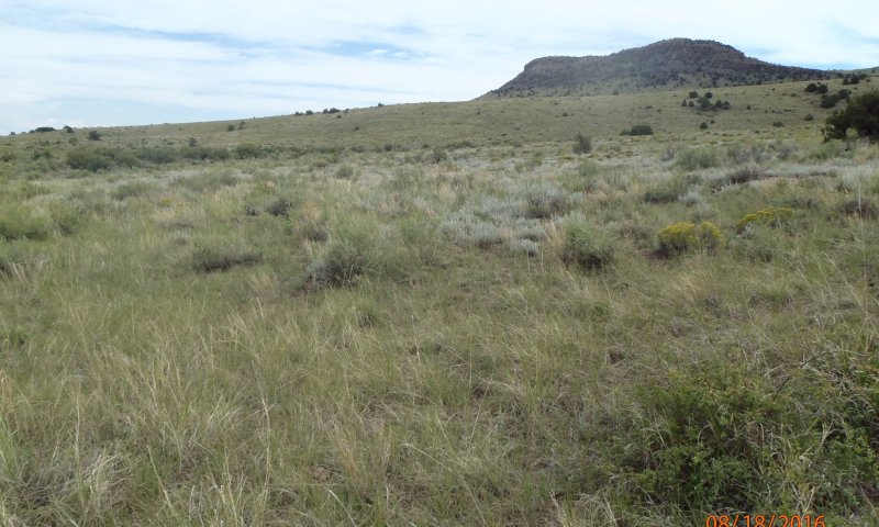
Figure 8. Cool and warm season grasses with shrubs and little bare ground.
The reference state contains a mix of cool and warm season grasses along with shrubs and forbs. Common shrubs include winterfat and fourwing saltbush. There may be scattered plants of Greene's rabbitbrush, fringed sage, snakeweed, rubber rabbitbrush, and yucca. Grasses are well distributed through the stand and make up nearly half the annual yield. Indian ricegrass, squirreltail, and blue grama are usually the main grasses. Western wheatgrass is common in places, and purple threeawn is usually present. Scarlet globemallow and other forbs are of minor importance.
Resilience management. The reference state holds the greatest opportunity for the site to resist disturbance. Bare ground is minimal, water capture, penetration, and infiltration is maximized. A diversity of plant and root systems interact with soil flora and fauna to maximize soil health. And a mix of cool and warm season plants maximize energy capture and carbohydrate synthesis.
Community 1.1 Cool and Warm Season Grass and Shrub Mix
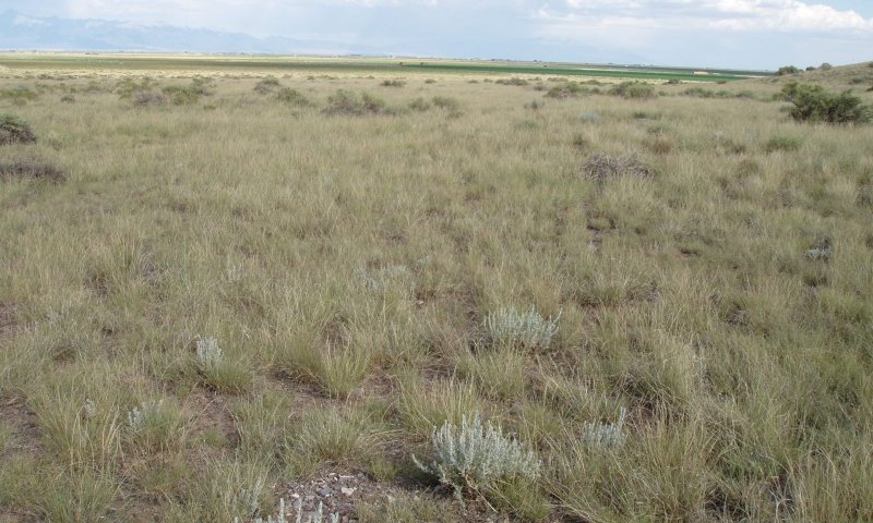
Figure 9. Cool and Warm Season Grass/Shrub Mix
This is the reference community and it is covered by both cool and warm-season grasses and shrubs. The dominant grasses include blue grama, Indian ricegrass, and western wheatgrass. Sub-dominant grasses include bottlebrush squirreltail, galleta (NM), sand dropseed, threeawn, and ring muhly. Significant forbs include scarlet globemallow, stoneseed, buckwheat, and groundsel species. Winterfat is the dominant shrub, making up 25-40% of the total vegetative production. Other shrubs include fourwing saltbush and occasionally, Greene's rabbitbrush.
Resilience management. This community phase provides the most ecosystem services and resilience to disturbance. Bare ground is minimal, plant cover captures precipitation and protects the soil surface. A diversity of cool and warm season plants maximizes energy capture, photosynthesis and above and below ground production.
Figure 10. Annual production by plant type (representative values) or group (midpoint values)
Table 5. Annual production by plant type
Plant type
Low (lb/acre)
Representative value (lb/acre)
High (lb/acre)
Shrub/Vine
186
305
400
Grass/Grasslike
146
265
360
Forb
18
30
40
Total
350
600
800
Community 1.2 Warm Season Dominant
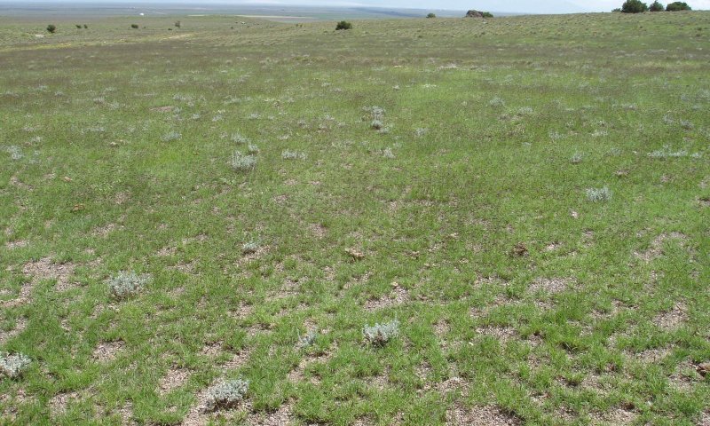
Figure 11. Cool season plants and overall production has decreased.
Overall above and below ground biomass and diversity is less than the reference community phase. Cool season plants such as Indian ricegrass, needle and thread, western wheatgrass, and winterfat have decreased in composition. Warm season grasses and shrubs dominate the site, especially blue grama. There may be small amounts of sand dropseed or threeawn.
Resilience management. This is an "at-risk" community phase with range and soil health trending downward from the reference community phase. This community phase is less resilient to drought as ecological processes such as fine root turnover, decomposition, and mineralization have decreased.
Pathway 1.1A Community 1.1 to 1.2
Cool and Warm Season Grass and Shrub Mix
Warm Season Dominant
Long term grazing for multiple years with repetitive defoliation and high utilization during the spring affects the recovery of cool season species. Preferred cool season grass species such as indian ricegrass, needle and thread, and western wheatgrass will be bitten repeatedly during the early growing season, A cool season shrub, such as winterfat will also be targeted for its protein value. Eventually warm season species, such as blue grama and threeawn, which are more adaptable to surviving under grazing grazing pressure due to defense mechanisms will be the more prominent species.
Pathway 1.2A Community 1.2 to 1.1
Warm Season Dominant
Cool and Warm Season Grass and Shrub Mix
A change in the grazing management to allow cool season species an opportunity to compete. This means either deferring or limiting grazing in the spring.
State 2 Degraded
Figure 12. Loss of cool-season species
Sand dropseed and blue grama are co-dominant. Squirreltail and Indian ricegrass have observed but are very sparse. Young winterfat plants have been observed with virtually no mature plants. Other common species include: galleta, Greene's rabbitbrush, and rubber rabbitbrush. Cool season grass and shrub species have been greatly reduced.
Resilience management. The site has become less resilient due to both a loss of the cool season component and an overall loss in above and below ground production. The cool season component is necessary to fully take advantage of cool temperatures and moisture in the spring and early fall. By removing the cool season component, the site suffers by reductions in soil organic matter, water capture, water retention, and cover against erosion.
Community 2.1 Warm Season Grass Dominant
Figure 13. Bare spaces are prevalent between plants.
Figure 14. Blue grama on an eroded pedestal.
This community phase is primarily blue grama dominant. Blue grama has natural grazing defenses such as the use of weak rhizomes and low apical meristems. Soil erosion is a factor as many blue grama plants sit on a pedestal. Luckily this site often has a heavy covering of gravel on the surface, helping to cover the soil.
Community 2.2 Warm Season Shrub Dominant
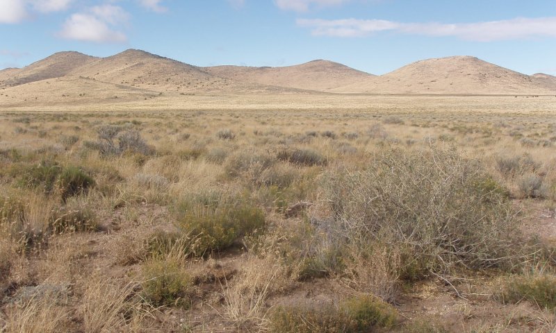
Figure 15. Warm season shrub dominant
Warm season shrubs such as Greene's rabbibrush, and rubber rabbitbrush are dominant. Fourwing saltbush and some warm season grasses such as sand dropseed and galleta will be present as well.
Pathway 2.1A Community 2.1 to 2.2
Warm Season Grass Dominant
Warm Season Shrub Dominant
Shrubs may have a competitive advantage during drought by utilizing deeper tap roots to obtain moisture and nutrients. The warm season shrubs on this site such as the rabbitbrush species are also not very palatable, therefore they do not receive grazing pressure. Unpalatable warm season grass species such as galleta and sand dropseed may also increase in composition.
Pathway 2.2A Community 2.2 to 2.1
Warm Season Shrub Dominant
Warm Season Grass Dominant
A disturbance knocks the shrubs back and low-stature blue grama persists.
State 3 Shrub Dominant
Figure 16. Winterfat with minor grasses
Winterfat dominates the plant community, while a few other remnant grass and shrub species are present. The soil, has formed a crust due to rain-drop erosion and the accumulation of carbonates at the surface. Species diversity is very low. Wildlife habitat is low. In some localized areas a desert pavement has formed. .
Community 3.1 Winterfat Dominant with Minor Shrubs
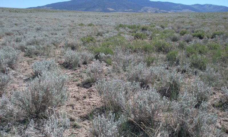
Figure 17. Greene's Rabitbrush expansion
Warm-season shrubs such as fourwing saltbush, Greene's rabbitbrush, and rubber rabbitbrush may find a niche to compete with winterfat. This may be due to some sort of physical soil disturbance.
Community 3.2 Winterfat Dominant with Minor Grasses
Figure 18. Winterfat dominant with blue grama
In places grasses will gain a foothold. Warm season grasses such as ring muhly and blue grama seem to be the most common grasses that can find a niche in this state. This community may be the beginning of a long road back toward restoration.
Pathway 3.1A Community 3.1 to 3.2
Winterfat Dominant with Minor Shrubs
Winterfat Dominant with Minor Grasses
A seed source and a safe spot for warm-season grasses to recolonize.
Pathway 3.2A Community 3.2 to 3.1
Winterfat Dominant with Minor Grasses
Winterfat Dominant with Minor Shrubs
Possibly a physical soil disturbance creates an area where rabbitbrush can colonize.
Transition T1A State 1 to 2
Reference
Degraded
The major long-term driver is annual grazing throughout the spring with repetitive defoliation and high utilization, slowly decreasing cool species vigor and decreasing site resistance to soil erosion. The eventual trigger event is often high utilization during drought.
Transition T1B State 1 to 3
Reference
Shrub Dominant
It could be possible that in decades past most of the plant community was grazed out. This was then followed by decades of non-use. Eventually, due to capillary action and rain-drop erosion, a high lime "soil cap" is formed. This soil surface condition retards grass establishment, and allows winterfat to have virtually no competition. .
Restoration pathway R2A State 2 to 1
Degraded
Reference
Ecological processes need to be restored which will take many years. Luckily the site is covered with frags, mostly gravel, therefore the soil surface is somewhat protected from erosion. Long-term low utilization and rest in the spring and fall will most likely be needed to allow colonization of cool season species. Maintaining adequate cover during the winter will also be important to provide warmth during low temperatures and capture for drifting snow.
Transition T2A State 2 to 3
Degraded
Shrub Dominant
In theory, long-term abandonment of a degraded state for many years will cause winterfat to re-establish and dominate to the exclusion of other species. It gains a competitive advantage as soils create a crust that greatly reduces the hydrologic function of the site and makes it difficult for other species to germinate. Carbonates also tend to accumulate near or on the surface which also restricts establishment by other species.
Restoration pathway R3A State 3 to 1
Shrub Dominant
Reference
Possibly a disturbance to knock the winterfat back plus interseeding of range species with a high tolerance for calcareous soil, may in theory start a restoration process.If a restoration process were to start and livestock grazing were re-instituted, an active monitoring component and adaptive management is needed for success.
Additional community tables
Table 6. Community 1.1 plant community composition
Location of Typical Example of the Site:
Rocky Creek Cemetery, about 7 miles southwest of Monte Vista in Rio Grande County; also along Highway 160 between Monte Vista and Del Norte in vicinity of Limekiln Creek.
Field Offices in Colorado where the site occurs:
Alamosa, Center, and San Luis
Chapman, S.S., G.E. Griffith, J.M. Omernik, A.B. Price, J. Freeouf, and D.L. Schrupp. 2006. Ecoregions of Colorado. (2-sided color posterwith map, descriptive text, summary tables, and photographs). U.S. Geological Survey, Reston, VA. Scale 1:1,200,000.
Cleland, D.T.; Freeouf, J.A.; Keys, J.E.; Nowacki, G.J.; Carpenter, C.A.; and McNab, W.H. 2007. Ecological Subregions: Sections andSubsections for the conterminous United States. Gen. Tech. Report WO-76D [Map on CD-ROM] (A.M. Sloan, cartographer). Washington,DC: U.S. Department of Agriculture, Forest Service, presentation scale 1:3,500,000; colored.
Soil Conservation Service (SCS). August 1975. Range Site Description for Limy Bench #276. : USDA, Denver Colorado.
United States Department of Agriculture, Natural Resources Conservation Service. 2006. Land Resource Regions and Major Land Resource Areas of the United States, the Caribbean, and the Pacific Basin. U.S. Department of Agriculture Handbook 296.
Contributors
Cindy Villa Scott Woodall
Approval
Kirt Walstad, 12/11/2024
Acknowledgments
Project Staff:
Suzanne Mayne-Kinney, Ecological Site Specialist, NRCS MLRA, Grand Junction SSO
Alan Stuebe, MLRA Soil Survey Leader, NRCS MLRA Alamosa SSO
Program Support:
Rachel Murph, NRCS CO State Rangeland Management Specialist, Denver
Eva Muller, Regional Director, Rocky Mountain Regional Soil Survey Office, Bozeman, MT
B.J. Shoup, CO State Soil Scientist, Denver
Eugene Backhaus, CO State Resource Conservationist, Denver
--Site Development and Testing Plan--:
Future work to validate and further refine the information in this Provisional Ecological Site Description is necessary. This will include field activities to collect low-, medium-, and high-intensity sampling, soil correlations, and analysis of that data.
Additional information and data are required to refine the Plant Production and Annual Production tables for this ecological site. The extent of MLRA 51 must be further investigated.
Field testing of the information contained in this Provisional ESD is required. As this ESD is moved to the Approved ESD level, reviews from the technical team, quality control, quality assurance, and peers will be conducted.
Rangeland health reference sheet
Interpreting Indicators of Rangeland Health is a qualitative assessment protocol used to
determine ecosystem condition based on benchmark characteristics described in the Reference Sheet. A suite of 17 (or
more) indicators are typically considered in an assessment. The ecological site(s) representative of an assessment
location must be known prior to applying the protocol and must be verified based on soils and climate. Current plant
community cannot be used to identify the ecological site.
Author(s)/participant(s)
S. Woodall, C. Villa, K. Diller, L. McBride
Contact for lead author
Date
12/14/2004
Approved by
Kirt Walstad
Approval date
Composition (Indicators 10 and 12) based on
Annual Production
Indicators
Number and extent of rills:
None to slight. If present, very short and discontinuous and apparent following intense rainfall events, on steeper slopes.
Presence of water flow patterns:
None, except following high intensity storms. Flow paths if present will be short (1-3 feet), with minimal evidence of past or current soil deposition.
Number and height of erosional pedestals or terracettes:
Very minor, if present, terracettes may occur in flow paths following intense storms, especially on steeper slopes.
Bare ground from Ecological Site Description or other studies (rock, litter, lichen, moss, plant canopy are
not bare ground):
10% or less bare ground, with bare patches generally less than 3-5 inches in diameter. Extended drought can cause bare ground to increase upwards to 10-15% with bare patches reaching upwards to 6-10 inches in diameter.
Number of gullies and erosion associated with gullies:
None
Extent of wind scoured, blowouts and/or depositional areas:
None
Amount of litter movement (describe size and distance expected to travel):
Litter movement is minimal and short.
Soil surface (top few mm) resistance to erosion (stability values are averages - most sites will show a range
of values):
Stability class rating anticipated to be 4-5 in interspaces at soil surface.
Soil surface structure and SOM content (include type of structure and A-horizon color and thickness):
Surface soils range from loam, gravelly loam to cobbly loam. The A-horizon is light brownish gray that can extend to 9 inches thick. The structure is typically weak ranging from fine granular to fine sub-angular blocky.
Effect of community phase composition (relative proportion of different functional groups) and spatial
distribution on infiltration and runoff:
Diverse grass, forb, shrub canopy and root structure reduces raindrop impact and slows overland flow providing increased time for infiltration to occur. Extended drought reduces grass and forb production causing decreased infiltration and increased runoff following intense storms.
Presence and thickness of compaction layer (usually none; describe soil profile features which may be
mistaken for compaction on this site):
None
Functional/Structural Groups (list in order of descending dominance by above-ground annual-production or live foliar
cover using symbols: >>, >, = to indicate much greater than, greater than, and equal to):
Dominant:
shrubs >
Sub-dominant:
cool season bunchgrass > warm season bunchgrass > cool season rhizomatous >
Other:
forbs
Additional:
Amount of plant mortality and decadence (include which functional groups are expected to show mortality or
decadence):
Minimum. Expect some natural mortality and decadence on bunchgrasses and shrubs.
Average percent litter cover (%) and depth ( in):
10-20% litter cover at 0.25 inch depth. Litter cover during and following extended drought ranges from 5-10%.
Expected annual annual-production (this is TOTAL above-ground annual-production, not just forage annual-production):
300 lbs./ac. low precip years; 600 lbs./ac. average precip years; 800 lbs./ac. above average precip years. After extended drought, production will be significantly reduced to 200 – 400 lbs./ac. or more.
Potential invasive (including noxious) species (native and non-native). List species which BOTH characterize
degraded states and have the potential to become a dominant or co-dominant species on the ecological site if
their future establishment and growth is not actively controlled by management interventions. Species that become
dominant for only one to several years (e.g., short-term response to drought or wildfire) are not invasive
plants. Note that unlike other indicators, we are describing what is NOT expected in the reference state for the
ecological site:
None
Perennial plant reproductive capability:
The only limitations are weather-related, natural disease, inter-species competition, wildlife, and insects that may temporarily reduce reproductive capability.
The Ecosystem Dynamics Interpretive Tool is an information system framework developed by the USDA-ARS Jornada Experimental Range, USDA Natural Resources Conservation Service, and New Mexico State University.
Click on box and path labels to scroll to the respective text.