Natural Resources
Conservation Service
Ecological site F054XY046ND
Upland Hardwood Forest
Last updated: 3/31/2025
Accessed: 04/15/2026
General information
Provisional. A provisional ecological site description has undergone quality control and quality assurance review. It contains a working state and transition model and enough information to identify the ecological site.
MLRA notes
Major Land Resource Area (MLRA): 054X–Rolling Soft Shale Plain
MLRA 54 covers 29,280 square miles and encompasses approximately 18.7 million acres. MLRA 54 spans three states with 64 percent of it in North Dakota, 33 percent in South Dakota, and 3 percent in Montana. Most of MLRA 54 is underlain by soft, calcareous shale, siltstone, and sandstone of the Tertiary Fort Union Group and the Cretaceous Fox Hills and Hell Creek Formations. Most of the soils in MLRA 54 developed from residuum weathered in place. Along the eastern and northern edges of the MLRA where MLRA 54 transitions into the glaciated Missouri plateau, remnants of glacial till parent materials remain on the high areas of the landscape. The MLRA 54 landscape is characterized by moderately dissected rolling plains with areas of local badlands, hills, and isolated buttes. Elevation is 1,650 feet (505 meters) on the eastern side of the MLRA with a gradual rise to 3,600 feet (1,100 meters) on the western side. The Missouri River runs along the north and east side of MLRA 54. Most of the Standing Rock Indian Reservation, the northwest third of the Cheyenne River Indian Reservation, and the Grand River National Grasslands are in the southern part of the MLRA.
Classification relationships
Level IV Ecoregions of the Conterminous United States: 43a – Missouri Plateau; 43c – River Breaks; 43j – Moreau Prairie.
Ecological site concept
The Upland Hardwood Forest ecological site occurs on moderately steep to very steep ridges on the Killdeer Mountains (limestone-capped buttes). The site typically has north or east aspect. Soils data suggests this site shifted temporally and spatially (via fire and drought) between sparsely wooded with herbaceous understory to closed canopy deciduous forest. Deciduous trees and shrubs are established in these areas, however periods of herbaceous plants increased on the site following fire. Soils on this site are well drained and deep or very deep. Typically, a thin O horizon (<3 inches thick) overlays the mineral soil. The A horizon, typically, has a loam texture. Immediately below the A horizon is a leached, grayish layer (E horizon); this horizon forms a ribbon 1 to 2 inches long. A layer of cay accumulation (Bt horizon) is below the E horizon; this horizon forms a ribbon >1.5 inches long. On the landscape, the Upland Hardwood Forest site is below the Shallow Loamy and Very Shallow ecological sites. Limy Residual and Loamy sites are on similar or lower landscape positions. Slopes range from 15 to 45 percent.
Due to steepness of slope, precipitation events, fires, hydrology, drought bedrock/parent material (e.g., limestone, mudstone or siltstone), soil conditions/development, and other factors, this ecological site is subject to rotational slides, also known as slumping (see Figure 2 below). Significant precipitation events saturating the soil profile, especially after a stand replacing fire, is a major contributing factor in a semi-arid climate on these steep slopes.
As the slide occurs, the sliding mass may stay intact and result in relatively small changes in site conditions. However, it may also break up into portions of different sizes and settle out in different orientations. Often, much of the vegetation present before the slide continues growing after being relocated by the slide. The result is a mosaic of various sized segments that can markedly differ in soil characteristics, aspect, areal extent, existing vegetation, and other factors. Over time different ecological sites may develop. As such, care should be given to identify any rotational slides, as well as whether the slide has resulted in a change in states, community phases, or perhaps ecological site(s).
To see a full copy of the ecological site description with all tables and the full version 5 rangeland health worksheet. Please use the following hyperlink:
https://efotg.sc.egov.usda.gov/references/public/ND/54_Upland_Harwood_Forest_Narrative_FINAL.pdf
Associated sites
| R054XY030ND |
Shallow Loamy This site is higher on the landscape than the Upland Hardwood Forest ecological site. The soils form a ribbon 1 to 2 inches long and have soft sedimentary bedrock at a depth of 10 to 20 inches. This ecological site has prairie vegetation. |
|---|---|
| R054XY031ND |
Loamy This site occurs on similar or lower landscape positions as the Upland Hardwood Forest site. The soils typically have a mollic epipedon and form a ribbon 1 to 2 inches long. They are deeper than 8 inches to carbonates. This ecological site has prairie vegetation. |
| R054XY035ND |
Very Shallow This site is higher on the landscape than the Upland Hardwood Forest ecological site. The soil is very gravelly or very cobbly (limestone fragments) within a depth of 20 inches. This ecological site has prairie vegetation. |
| R054XY046ND |
Limy Residual This site occurs on similar or lower landscape positions as the Upland Hardwood Forest site. The soil is >20 inches to soft sedimentary bedrock. The surface and subsoil layers form a ribbon 1 to 2 inches long; it is calcareous within a depth of 8 inches. |
Similar sites
| R054XY031ND |
Loamy This site occurs on similar or lower landscape positions as the Upland Hardwood Forest site. The soils typically have a mollic epipedon and form a ribbon 1 to 2 inches long. They are deeper than 8 inches to carbonates. This ecological site has prairie vegetation, but a wooded state similar to Upland Hardwood Forest maybe present. |
|---|
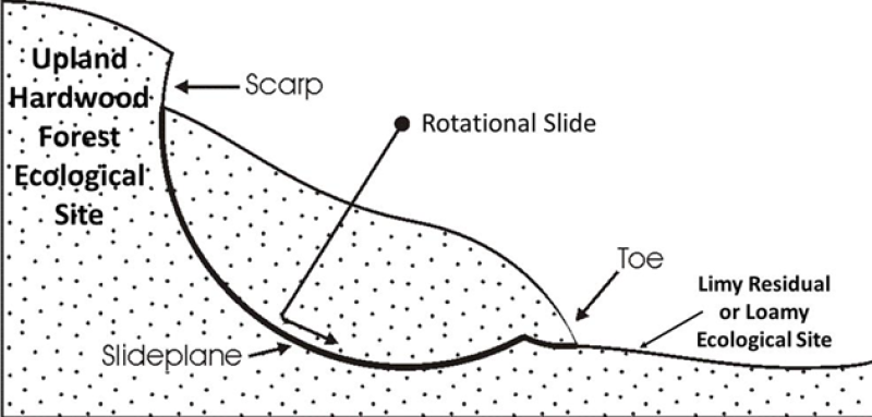
Figure 1. Figure 2. Rotational landslides are caused by the downward and outward movement of a mass on top of a concave upward failure surface (Abbott 2004).
Table 1. Dominant plant species
| Tree |
(1) Populus tremuloides |
|---|---|
| Shrub |
(1) Amelanchier alnifolia |
| Herbaceous |
(1) Aralia nudicaulis |
Physiographic features
This ecological site occurs on sideslopes of ridges (draws), as well as on slumps, hillslopes, and associated sedimentary uplands. Parent materials are colluvium from weathered, sedimentary bedrock (siltstone, mudstone, sandstone, and/or shale) or glacial till. The landscape position and aspect strongly influenced the development of this ecological site. Slope ranges from 15 to 45 percent.
Table 2. Representative physiographic features
| Landforms |
(1)
Ridge
|
|---|---|
| Runoff class | High |
| Flooding frequency | None |
| Ponding frequency | None |
| Elevation | 1,650 – 3,600 ft |
| Slope | 15 – 45% |
| Water table depth | 80 in |
| Aspect | N, NE, E |
Climatic features
MLRA 54 is considered to have a continental climate with cold winters and hot summers, low humidity, light rainfall, and much sunshine. Extremes in temperature are common and characteristic of the MLRA. The continental climate is the result of this MLRA’s location in the geographic center of North America. There are few natural barriers on the northern Great Plains, so air masses move unobstructed across the plains and account for rapid changes in temperature.
Annual precipitation ranges from 14 to 18 inches per year. The normal average annual temperature is about 42° F. January is the coldest month with average temperatures ranging from about 13° F (Beach, ND) to about 16° F (Bison, SD). July is the warmest month with temperatures averaging from about 69° F (Beach, ND) to about 72° F (Timber Lake, SD). The range of normal average monthly temperatures between the coldest and warmest months is about 57° F. This large temperature range attests to the continental nature of MLRA 54’s climate. Wind speeds average about 11 miles per hour, ranging from about 13 miles per hour during the spring to about 10 miles per hour during the summer. Daytime wind speeds are generally stronger than nighttime wind speeds, and occasional strong storms may bring brief periods of high winds with gusts to more than 50 miles per hour.
Growth of native cool-season plants begins in late March and continues through early to mid-July. Native warm-season plants begin growth in mid-May and continue to the end of August. Greening up of cool-season plants can occur again in September and October when adequate soil moisture is present.
Table 3. Representative climatic features
| Frost-free period (characteristic range) | 95-111 days |
|---|---|
| Freeze-free period (characteristic range) | 118-127 days |
| Precipitation total (characteristic range) | 15-18 in |
| Frost-free period (actual range) | 91-114 days |
| Freeze-free period (actual range) | 116-129 days |
| Precipitation total (actual range) | 15-18 in |
| Frost-free period (average) | 101 days |
| Freeze-free period (average) | 123 days |
| Precipitation total (average) | 16 in |
Figure 2. Monthly precipitation range
Figure 3. Monthly minimum temperature range
Figure 4. Monthly maximum temperature range
Figure 5. Monthly average minimum and maximum temperature
Figure 6. Annual precipitation pattern
Figure 7. Annual average temperature pattern
Climate stations used
-
(1) FT YATES 4 SW [USC00323207], Fort Yates, ND
-
(2) DUPREE [USC00392429], Dupree, SD
-
(3) HETTINGER [USC00324178], Hettinger, ND
-
(4) WATFORD CITY [USC00329233], Watford City, ND
-
(5) MANDAN EXP STN [USC00325479], Mandan, ND
-
(6) LUDLOW 3 SSE [USC00395048], Ludlow, SD
-
(7) HEBRON [USC00324102], Hebron, ND
Influencing water features
This ecological site is on a runoff landscape position; however, it does receive extra moisture by holding more snowfall than non-wooded sites. The seasonal ground water table is typically deeper than 6 feet throughout the growing season. Permeability is moderately slow to moderate. Water loss is through evapotranspiration and percolation below the root zone. The primary north and east aspects and tree canopy provide benefit by keeping the soil surface shaded and cooler than non-wooded sites, thus reducing the rate of evaporation.
Soil features
Most soils associated with the Upland Hardwood Forest ES are in the Alfisol order; however, soils in the Mollisol order may also occur. The Alfisols are classified further as Typic Hapludalfs. The Mollisols are classified further as Typic Argiustolls. The soils were developed under forested conditions. Most soils have obvious indicators of forest influence (alfic properties). They formed in residuum. Fragments of Iimestone are common in the soil profile. The soils on this site are very deep or deep and are well drained.
The soils commonly have a thin surface layer (<3 inches thick) of slightly decomposed organic material and leaf litter. Textures of the mineral A horizon are typically loam. Below the A horizon, most soils have an albic (E) horizon with an argillic (Bt) horizon below the E horizon. However, soils without E horizons are included in the site. The texture of the E horizon, typically, is loam. The texture of the Bt horizon, typically, is clay loam; the soil forms a ribbon >1.5 inches long. Some soils may have pieces of charcoal in the soil profile which indicates the influence of fire. Some soils have soft sedimentary bedrock as shallow as 4 feet.
Soil reaction in the mineral A and E horizons typically is strongly acid to neutral (pH 5.1 to 7.3). In the Bt horizon, soil reaction is moderately acid to slightly alkaline (pH 5.6 to 73); the substratum may have pH as high as 8.4 (moderately alkaline). Soil salinity is none to very slight (E.C. <2 dS/m); sodicity is typically none. Calcium carbonate content is none from the surface through the Bt horizon. In the substratum, calcium carbonate content may be as high as 10 percent. Soils on the Upland Hardwood Forest ecological site typically is not susceptible to erosion under reference conditions.
The major soil series which characterizes the Upland Hardwood Forest ecological site is Lakoa.
Access Web Soil Survey (https://websoilsurvey.sc.egov.usda.gov/App/WebSoilSurvey.aspx) for specific local soils information.
Parent Material Kind: colluvium from residuum
Parent Material Origin: limestone, siltstone
Table 4. Representative soil features
| Parent material |
(1)
Colluvium
–
limestone
(2) Colluvium – siltstone |
|---|---|
| Surface texture |
(1) Loam |
| Family particle size |
(1) Loamy |
| Drainage class | Well drained |
| Permeability class | Moderately slow to moderate |
| Depth to restrictive layer | 60 – 80 in |
| Soil depth | 60 – 80 in |
| Surface fragment cover <=3" | Not specified |
| Surface fragment cover >3" | Not specified |
| Available water capacity (Depth not specified) |
6 – 10 in |
| Calcium carbonate equivalent (Depth not specified) |
15% |
| Electrical conductivity (Depth not specified) |
2 mmhos/cm |
| Sodium adsorption ratio (Depth not specified) |
Not specified |
| Soil reaction (1:1 water) (Depth not specified) |
5.1 – 8.4 |
| Subsurface fragment volume <=3" (Depth not specified) |
14% |
| Subsurface fragment volume >3" (Depth not specified) |
14% |
Ecological dynamics
This ecological site description is based on nonequilibrium ecology and resilience theory and utilizes a State- and-Transition Model (STM) diagram to organize and communicate information about ecosystem change as a basis for management. The ecological dynamics characterized by the STM diagram reflect how changes in ecological drivers, feedback mechanisms, and controlling variables can maintain or induce changes in plant community composition (phases and/or states). The application of various management actions, combined with weather variables, impact the ecological processes which influence the competitive interactions, thereby maintaining or altering plant community structure.
Prior to European influence, the historical disturbance regime for MLRA 54 included frequent fires, both anthropogenic and natural in origin. Most fires, however, were anthropogenic fires set by Native Americans. Native Americans set fires in all months except perhaps January. These fires occurred in two peak periods, one from March-May with the peak in April and another from July-November with the peak occurring in October. Most of these fires were scattered and of small extent and duration. The grazing history would have involved grazing and browsing by large herbivores (such as American bison, elk, and whitetail deer). Herbivory by small mammals, insects, nematodes, and other invertebrates are also important factors influencing the production and composition of the communities. Grazing and fire interaction, particularly when coupled with drought events, influenced the dynamics discussed and displayed in the following state and transition diagram and descriptions.
Following European influence, this ecological site generally has had a history of grazing by domestic livestock, particularly cattle, which along with other related activities (e.g., fencing, water development, fire suppression) has changed the disturbance regime of the site. Changes will occur in the plant communities due to these and other factors.
Weather fluctuations, coupled with managerial factors, may lead to changes in the plant communities and may, under adverse impacts, result in a slow decline in vegetative vigor and composition. However, under favorable conditions the botanical composition may resemble that prior to European influence.
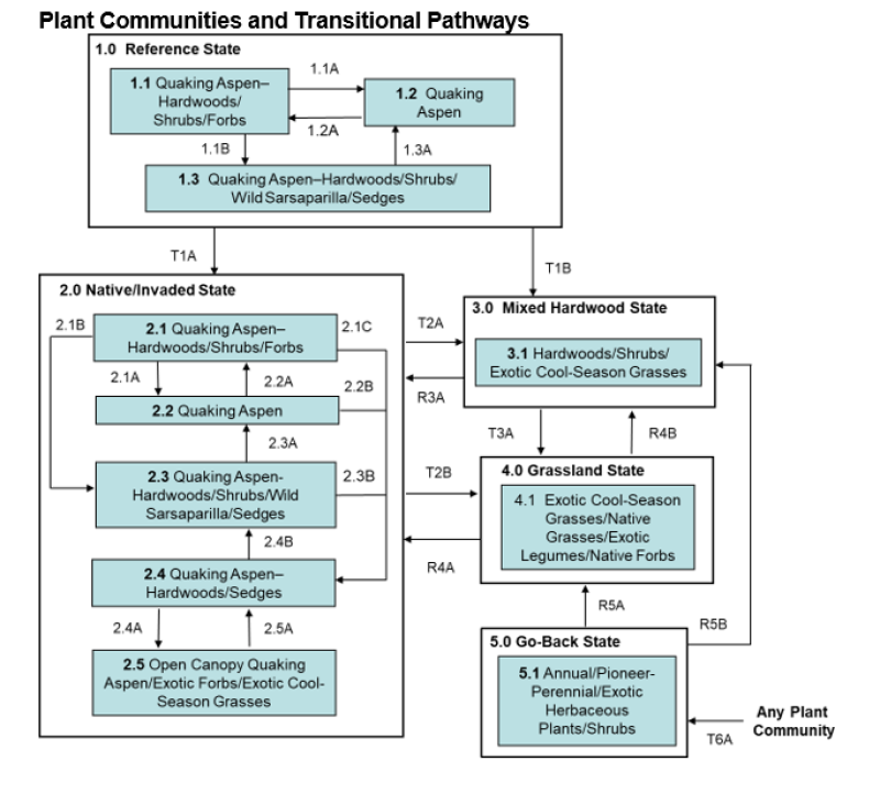
Five vegetative states have been identified for the site (Reference, Native/Invaded, Mixed Hardwood, Grassland, and Go-Back). Within each state, one or more community phases have been identified. These community phases are named based on the more dominant and visually conspicuous species and have been determined by study of historical documents, relict areas, scientific studies, and ecological aspects of plant species and plant communities. Transitional pathways and thresholds have been determined through similar methods.
State 1: Reference State represents the historical natural range of variability that dominated the dynamics of this ecological site prior to European influence. This state may be characterized as a quaking aspen dominated forest with a shrub understory. It is thought to have shifted temporally and spatially between three plant community phases. The major differences in the community phases are due to the age classes of quaking aspen.
Since European influence, fires have been significantly reduced while other disturbances such as timber harvesting and grazing by domestic livestock have increased. As a result, the historical disturbance regime no longer exists. Because of these and other changes including the widespread occurrence of exotic plants, the Reference State is considered to no longer exist. Thus, the presence of exotic plants on the site (e.g., Kentucky bluegrass, smooth brome, common buckthorn) precludes it from being placed in the Reference State. It must be placed in one of the other states, commonly State 2: Native/Invaded State (T1A). Extended periods of non-use and no fire will lead to State 3: Mixed Hardwood State (T1B).
State 2: Native/Invaded State. This state forms outside the historical disturbance regime, largely because of the long-term elimination of fire, timber harvesting, livestock grazing, and the introduction of exotic plants (e.g., exotic cool-season grasses). Community phases are similar to those of the Reference State but have been invaded by exotic plants. Extended periods of non-use and no fire will lead to a transition to State 3: Mixed Hardwood State (T2A). Clear-cutting followed by heavy continuous grazing will lead to State 4: Grassland State (T2B).
Kentucky bluegrass and/or smooth brome are the main exotic cool-season grasses. Presently the distribution of common buckthorn in MLRA 54 has been relatively limited, however, it is spreading. Due to its invasive nature and habit of displacing native understory species, it is a threat to biodiversity. As a result, periodic monitoring for the species is recommended and if the plant is encountered, control measures implemented.
State 3: Mixed Hardwood State. This state consists of one community phase and may develop under extended periods of non-use and no fire from State 2: Native/Invaded State (T2A). It may also develop from State 5: Go-Back State via a forestry planting (e.g., Tree-Shrub Establishment) or secondary succession (R5B). This state is dominated by green ash and/or bur oak, along with associates of American elm, boxelder, paper birch, and quaking aspen. Considerable variation may exist in the relative abundance of the dominant tree species due to variations in slope, precipitation, and other natural and anthropogenic factors.
Reestablishment of natural disturbance regimes (e.g., prescribed burning) will lead to State 2: Native/Invaded State (R3A) provided remaining quaking aspen are still viable to regenerate. Clear-cutting followed by continuous heavy grazing will lead to State 4: Grassland State (T3A).
State 4: Grassland State. This state consists of one community phase and may occur due to clear-cutting with continuous heavy grazing from State 2: Native/Invaded State (T2B) or State 3: Mixed Hardwood State (T3A). It may also result from State 5: Go-Back State through a range, pasture, or hayland planting (R5A). Extended periods of non-use and no fire will lead to State 2: Native/Invaded State (R4A). A forestry planting (e.g., Tree-Shrub Establishment) will lead to State 3: Mixed Hardwood State (R4B).
State 5: Go-Back State often results from cropland abandonment and consists of only one community phase. This weedy assemblage may include noxious weeds that need control. Initially, due to extensive bare ground and a preponderance of shallow rooted annual plants, the potential for soil erosion is high. Plant species richness may be high, but overall diversity (i.e., equitability) is typically low, with the site dominated by a relatively small assemblage of species. Due to the lack of native perennials and other factors, restoring the site with the associated ecological processes is difficult. A range, pasture, or hayland planting leads to State 4: Grassland State (R5A). A properly designed/successful forestry planting (e.g., Tree-Shrub Establishment) may result in a plant community resembling State 2: Native/Invaded State (R5B). Following planting, management techniques that maintain the planting will need to be carefully constructed, evaluated, and monitored with respect to that objective. This pathway may also occur with secondary succession.
Juniper Invasion - Juniper species may have been present as scattered trees or shrubs prior to European influence. Since that time, decreased fire frequency, increased fire suppression, and dispersal from shelterbelts have been particularly important in enabling junipers to increase and potentially dominate a wide range of rangeland and forest land ecological sites in MLRA 54. Extended periods of non-use or very light grazing may also be factors.
Where a conifer seed source is available, woody encroachment begins to expand, exploit, and eventually dominate the sites, threatening the ecological integrity of the sites. Without managerial intervention these sites may transition to a Conifer Invaded State. As depicted in the following diagram, confer seeds disperse into an intact grassland beginning the process of woody encroachment.
The following state and transition model diagram illustrates the common states, community phases, community pathways, and transition and restoration pathways that can occur on the site. These are the most common plant community phases and states based on current knowledge and experience; changes may be made as more data are collected. Pathway narratives describing the site’s ecological dynamics reference various management practices (e.g., prescribed burning, brush management, herbaceous weed treatment) which, if properly designed and implemented, will positively influence plant community competitive interactions. The design of these management practices will be site specific and should be developed by knowledgeable individuals; based upon management goals and a resource inventory; and supported by an ongoing monitoring protocol.
When the management goal is to maintain an existing plant community phase or restore to another phase within the same state, modification of existing management to ensure native species have the competitive advantage may be required. To restore a previous state, the application of two or more management practices in an ongoing manner will be required. Whether using prescribed burning, with or without additional practices (e.g., brush management), the timing and method of application needs to favor the native species over the exotic species. Adjustments to account for variations in annual growing conditions and implementing an ongoing monitoring protocol to track changes and adjust management inputs to ensure desired outcome will be necessary.
The plant community phase composition table(s) has been developed from the best available knowledge including research, historical records, clipping studies, and inventory records. As more data are collected, plant community species composition and production information may be revised.
State and transition model
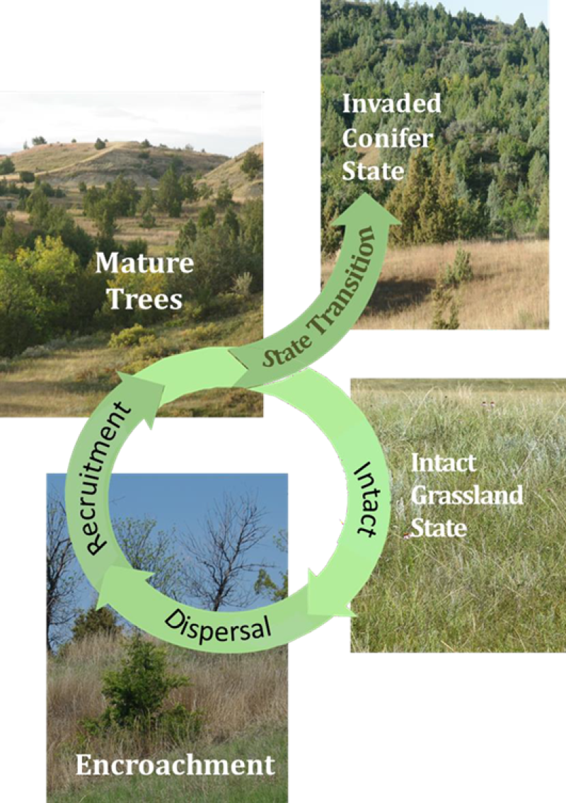
Figure 8. Figure 1. Stages of Woody Encroachment - Adapted from: Reducing Woody Encroachment in Grasslands – A Guide for Understanding Risk and Vulnerability; Oklahoma Cooperative Extension Service
More interactive model formats are also available.
View Interactive Models
More interactive model formats are also available.
View Interactive Models
Click on state and transition labels to scroll to the respective text
Ecosystem states
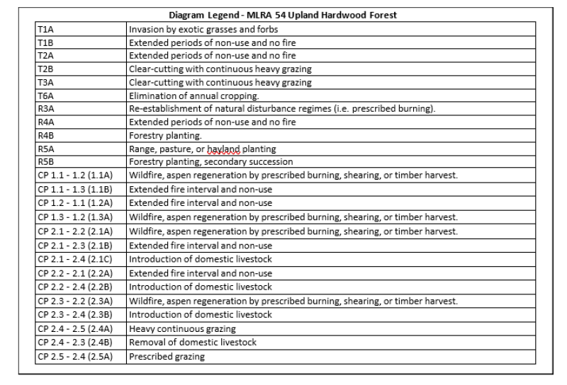
| T1A | - | Invasion by exotic grasses and forbs |
|---|---|---|
| T1B | - | Extended periods of non-use and no fire |
| T2A | - | Extended periods of non-use and no fire |
| T2B | - | Clear-cutting with continuous heavy grazing |
| R3A | - | Re-establishment of natural disturbance regimes (i.e. prescribed burning). |
| T3A | - | Clear-cutting with continuous heavy grazing |
| R4A | - | Extended periods of non-use and no fire |
| R4B | - | Forestry planting. |
| R5B | - | Forestry planting, secondary succession |
| R5A | - | Range, pasture, or hayland planting |
| T6A | - | Elimination of annual cropping. |
State 1 submodel, plant communities
| 1.1A | - | Wildfire, aspen regeneration by prescribed burning, shearing, or timber harvest. |
|---|---|---|
| 1.1B | - | Extended fire interval and non-use |
| 1.2A | - | Extended fire interval and non-use |
| 1.3A | - | Wildfire, aspen regeneration by prescribed burning, shearing, or timber harvest. |
State 2 submodel, plant communities
| 2.1A | - | Wildfire, aspen regeneration by prescribed burning, shearing, or timber harvest. |
|---|---|---|
| 2.1B | - | Extended fire interval and non-use |
| 2.1C | - | Introduction of domestic livestock |
| 2.2A | - | Extended fire interval and non-use |
| 2.2B | - | Introduction of domestic livestock |
| 2.3A | - | Wildfire, aspen regeneration by prescribed burning, shearing, or timber harvest. |
| 2.3B | - | Introduction of domestic livestock |
| 2.4B | - | Removal of domestic livestock |
| 2.4A | - | Heavy continuous grazing |
| 2.5A | - | Prescribed grazing |
State 3 submodel, plant communities
State 4 submodel, plant communities
State 5 submodel, plant communities
State 1
Reference State
This state may be characterized as a forest dominated by quaking aspen, often with an understory of shrubs. Plant community phases occurred as a mosaic across the site resulting from variations in the frequency and intensity of fires and other disturbances (e.g., blowdown, grazing/browsing by native ungulates). Differences in the community phases were largely due to the age classes of quaking aspen predominant on the site resulting from these disturbances. The Reference State represents the natural range of variability that dominated the dynamics of this ecological site prior to European influence. This site was dominated by quaking aspen, often with an understory of shrubs. Other associated trees included green ash, boxelder, American elm, bur oak, and paper birch. Chokecherry, Saskatoon serviceberry, hazel, and Woods’ rose were commonly associated shrubs. Graminoids common to this state were limited largely to sedges (e.g., Sprengel’s, Pennsylvania), rough ricegrass, and fringed brome. Common forbs included wild sarsaparilla, violets, bedstraws, zizia, wild bergamot, stary false lily of the valley (false Solomon seal), longstyle sweetroot, and blue giant hyssop. In older stands, canopy cover may be 90% or more, however, gaps in canopy cover such as that created by heart rot and windthrow result in increased light penetration and may lead to an increase in herbaceous diversity and production.
Characteristics and indicators. The reference state may still exist; however, due to changes in disturbances and other environmental factors (particularly the widespread occurrence of exotic species), it may be rare.
Resilience management. If intact, the reference state should probably be managed with current disturbance regimes which has permitted the site to remain in reference condition, as well as maintaining the quality and integrity of associated ecological sites. Maintenance of the reference state is contingent upon a monitoring protocol to guide management.
Community 1.1
Quaking Aspen-Hardwoods/Shrubs/Forbs
Community Phase 1.1 is considered the Reference Plant Community upon which most interpretations are based. This community evolved with occasional fires, blowdown, and grazing/browsing by native ungulates. The community was dominated by quaking aspen between 20-50 years old (approximately 4-16 inches DBH), with green ash and bur oak as the principal associates. Associated shrubs included beaked hazel, chokecherry, Saskatoon serviceberry, Woods’ rose, hazel, and poison ivy. Forbs’s characteristic of this community often included wild sarsaparilla, violets, bedstraws, stary false lily of the valley (false Solomon seal) zizia, Solomon seal, wild bergamot, blue giant hyssop, and longstyle sweetroot. The graminoid component was largely limited to sedges and rough ricegrass.
Community 1.2
Quaking Aspen
This plant community was the result of frequent fire events or other disturbances resulting in a forest community dominated by quaking aspen of age classes less than 20 years old (approximately less than 4 inches DBH). The community may be described as a virtually pure stand of young quaking aspen with a closed canopy that limits other trees, shrubs, and herbaceous species. Where the quaking aspen canopy was more open, a sparse shrub component may have been composed of hazel, chokecherry, Saskatoon serviceberry, poison ivy, and Woods’ rose with herbaceous species largely consisting of wild sarsaparilla and sedges.
Community 1.3
Quaking Aspen-Hardwoods/Shrubs/Wild Sarsaparilla/Sedges
This community formed when fires and other disturbances were so infrequent or minor as to enable quaking aspen that is 50 years old or more (approximately 16 or more inches DBH) to dominate the site. Major associates of the canopy and sub-canopy were green ash, bur oak, boxelder, American elm, poison ivy, and paper birch, with an understory shrub layer largely composed of chokecherry, Saskatoon serviceberry, and Woods’ rose. The age of the quaking aspen was approaching maturity and may have contained decadent trees as evidenced by increased heart rot, reduced canopy cover, and more frequent windthrow. Sedges and wild sarsaparilla accounted for much of the herbaceous component.
Pathway 1.1A
Community 1.1 to 1.2
Plant Community Phase Pathway 1.1 to 1.2 occurred with wildfire or other disturbances causing considerable mortality of older quaking aspen resulting in the stand being replaced with quaking aspen trees 20 years old or less. If Community Phase 1.1 is encountered, this pathway may occur with aspen regeneration by prescribed burning, shearing, or timber harvesting. An effective technique for regenerating quaking aspen is to shear trees at ground level with a bulldozer during the winter when ground is frozen. Assuming the quaking aspen is not decadent and can no longer sprout readily, a strong sprouting response generally occurs (e.g., 20,000- 40,000 stems per acre). Over time, the stand will self-thin. A few selected trees of quaking aspen and other species may be left standing and, generally, will not interfere with the quaking aspen regeneration.
Pathway 1.1B
Community 1.1 to 1.3
Plant Community Phase Pathway 1.1 to 1.3 occurred with extended fire intervals and non-use that were sufficient to allow the quaking aspen stands to age and become dominated by quaking aspen of at least 50- year-old trees.
Pathway 1.2A
Community 1.2 to 1.1
Plant Community Phase Pathway 1.2 to 1.1 occurred with extended fire intervals and non-use that were sufficient to enable 20–50-year-old quaking aspen trees to dominate the site. The shrub understory of Community Phase 1.1 was typically more developed and diverse than that of Community Phase 1.2. It was often composed of hazel with associates of chokecherry, Saskatoon serviceberry, and Woods’ rose along with young green ash and bur oak forming a mid-canopy. The herbaceous layer often included wild sarsaparilla, bedstraws, and violets. Sedges and rough ricegrass were the main graminoids.
Pathway 1.3A
Community 1.3 to 1.2
Plant Community Phase Pathway 1.3 to 1.2 occurred with wildfire or other disturbances causing considerable mortality of older quaking aspen resulting in the stand being replaced with quaking aspen trees 20 years old or less. If Community Phase 1.3 is encountered, this pathway may occur with aspen regeneration by prescribed burning, shearing, or timber harvesting. An effective technique for regenerating quaking aspen is to shear trees at ground level with a bulldozer during the winter when ground is frozen. Assuming the quaking aspen is not decadent and no longer can sprout readily, a strong sprouting response generally occurs (e.g., 20,000- 40,000 stems per acre). Over time the stand will self-thin. A few selected trees of quaking aspen and other species may be left standing and will generally not interfere with the quaking aspen regeneration.
State 2
Native/Invaded State
This state consists of similar community phases as is found in State 1: Reference State (i.e., Community Phases 1.1, 1.2, 1.3) but has been invaded by exotic plants. Also, the disturbances associated with the introduction of domestic livestock may markedly alter the native component and exacerbate the invasion by exotic plants (e.g., Community Phases 2.4). Initially, these changes are more structural than compositional. Domestic livestock establish travel corridors in the forest as well as use the forest for shade and rest which creates openings in the shrub component of the community. Over time, weaker stemmed shrubs (e.g. chokecherry, Saskatoon serviceberry) decrease in abundance due to the increased disturbance. As a result, hazel, which has stronger and more resistant stems, becomes even more dominant. Because the maximum height of grazing/browsing for cattle is about five feet, resprouts of quaking aspen and other woody vegetation within reach of the domestic livestock are subject to repeated herbivory, which will reduce recruitment. Continued season-long grazing by domestic livestock will lead to changes in the structure, composition, and production of the site. With a more open shrub component, increased light penetration to the forest floor leads to greater herbaceous production, particularly by sedges. The disturbance associated with continued season-long grazing exacerbates the invasion of the site by exotic plants. Presently, the distribution of common buckthorn in MLRA 54 has been relatively limited. However, it is spreading, and due to its invasive nature and habit of displacing native understory species it is a threat to biodiversity. As a result, periodic monitoring for the species is recommended, and if the plant is encountered, control measures implemented.
Characteristics and indicators. The presence of trace amounts of exotic cool-season grasses (e.g., Kentucky bluegrass and smooth brome) indicates a transition from State 1 to State 2. The presence of exotic biennial or perennial forbs (e.g., common dandelion, red clover, white clover, and black medic) may not, on their own, indicate a transition from State 1 to State 2 but may facilitate that transition.
Resilience management. The invasion of these exotic grasses is associated with stand clearing activities, such as shearing or intensive fire, which removes tree canopy cover. Canopy closure may reduce or eliminated exotics species. To maintain State 2.0 Native/Invaded State, forest management practices need to be completed. Livestock grazing is incompatible with maintaining a forest dominated state; it will likely result in a pathway to an open canopy (Plant Community Phases 2.4).
Community 2.1
Quaking Aspen-Hardwoods/Shrubs/Forbs
This community is similar to Community Phase 1.1 (dominated by quaking aspen 20-50 years old) but now supports populations of exotic plants. Common exotics may include Kentucky bluegrass, smooth brome, common dandelion, white clover, red clover, and black medic.
Community 2.2
Quaking Aspen
This community is similar to Community Phase 1.2 (dominated by quaking aspen 20 years old or less) but now supports populations of exotic plants. Shading by young and vigorous growth of quaking aspen may limit exotics, but as the stand matures the canopy opens-up. Common exotics often include Kentucky bluegrass, smooth brome, common dandelion, white clover, red clover, and black medic.
Community 2.3
Quaking Aspen-Hardwoods/Shrubs/Wild Sarsaparilla/Sedges
This community is similar to Community Phase 1.3 (dominated by quaking aspen 50 years old or older), but now supports populations of exotic plants (e.g., Kentucky bluegrass, smooth brome, red clover, white clover, and black medic).
Community 2.4
Quaking Aspen-Hardwoods/Sedges
This community phase is similar to Community Phase 2.3 but with major differences, principally in the shrub component, due to grazing/browsing by domestic livestock. Continued season-long grazing by domestic livestock begins to open the shrub component resulting in a decline of weaker stemmed shrubs (e.g., chokecherry, Saskatoon serviceberry, and Woods’ rose) with a corresponding increase in exotic herbaceous species. This community phase may be short lived with the risk of transitioning to State 3.0 Invaded State. Proper management would allow the recruitment of quaking aspen resprouts and other woody species.
Community 2.5
Open Canopy Quaking Aspen/Exotic Forbs/Exotic Cool-Season Grasses
This community phase may be characterized by a quaking aspen forest, generally of an older age class, where the disturbance of unregulated grazing by domestic livestock (e.g., soil compaction, trailing, bedding, and the like) has led to a decline in vigor and increased mortality of the forest canopy species. These affects in combination with the aging aspen canopy and aspen heart rot result in a more open and decadent stand of quaking aspen with little or no recruitment. Other canopy species such as bur oak and green ash also show signs of decline (e.g., barking, increase in dead branches). Beaked hazel may dominate the shrub component, but over time will decline with heavy season-long grazing. With the increased disturbance and more open canopy, exotic plants replace the native components. Herbaceous production and composition typically consist of exotic species such as Kentucky bluegrass, smooth brome, creeping bentgrass, common dandelion, blackseed plantain, black medic, white clover, and red clover.
Pathway 2.1A
Community 2.1 to 2.2
Community Phase Pathway 2.1 to 2.2 occurs when wildfire or aspen regeneration by prescribed burning, shearing, or timber harvesting results in a forest community dominated by quaking aspen of age classes less than 20 years old. An effective technique for regenerating quaking aspen is to shear trees at ground level with a bulldozer during the winter when ground is frozen. Assuming the quaking aspen is not decadent and can no longer sprout readily, a strong sprouting response generally occurs (e.g., 20,000-40,000 stems per acre). Over time, the stand will self-thin. A few selected trees of quaking aspen and other species may be left standing and, generally, will not interfere with the quaking aspen regeneration.
Pathway 2.1B
Community 2.1 to 2.3
Community Phase Pathway 2.1 to 2.3 occurs when an extended fire interval and non-use Is sufficient to allow the quaking aspen stands to age and become dominated by quaking aspen of at least 50-year-old trees.
Pathway 2.1C
Community 2.1 to 2.4
Community Phase Pathway 2.1 to 2.4 occurs with the introduction of domestic livestock resulting in a more open forest canopy and shrub component leading to an increase in exotic plants.
Pathway 2.2A
Community 2.2 to 2.1
Community Phase Pathway 2.2 to 2.1 occurs when extended fire intervals and non-use are sufficient to enable 20-50-year-old quaking aspen trees to dominate the site.
Pathway 2.2B
Community 2.2 to 2.4
Community Phase Pathway 2.2 to 2.4 occurs with the introduction of domestic livestock resulting in a more open forest canopy and shrub component leading to an increase in exotic plants.
Pathway 2.3A
Community 2.3 to 2.2
Community Phase Pathway 2.3 to 2.2 occurs when wildfire, aspen regeneration by prescribed burning, shearing, or timber harvesting or other disturbances causes considerable mortality of older quaking aspen causing the stand to be replaced with quaking aspen trees 20 years old or less.
Pathway 2.3B
Community 2.3 to 2.4
Community Phase Pathway 2.3 to 2.4 occurs with the introduction of domestic livestock resulting in a more open forest canopy and shrub component leading to an increase in exotic plants.
Pathway 2.4B
Community 2.4 to 2.3
Community Phase Pathway 2.4 to 2.3 occurs with the removal of domestic livestock which allows for the increase in shrub abundance and diversity (e.g., chokecherry, Saskatoon serviceberry).
Pathway 2.4A
Community 2.4 to 2.5
Community Phase Pathway 2.4 to 2.5 occurs with heavy continuous grazing which opens the tree canopy and leads to a marked increase of exotic forbs and cool-season grasses.
Pathway 2.5A
Community 2.5 to 2.4
Community Phase Pathway 2.5 to 2.4 may occur with the implementation of prescribed grazing.
State 3
Mixed Hardwood State
This state may develop under conditions of long-term lack of disturbance (>50 years), allowing the mature quaking aspen dominated forest to become decadent and be replaced by green ash and/or bur oak along with associates of boxelder and paper birch. Quaking aspen is a shade intolerant species, thus generally regarded as an early successional species that would give way to more shade tolerant species in later successional states. As such, in a traditional successional pathway on this site quaking aspen would be expected to be replaced by more shade tolerant species such as green ash, bur oak, and boxelder. However, in some instances quaking aspen may persist. It is unclear to what extent quaking aspen may remain in this community. Considerable variation may exist in the relative abundance of the dominant tree species in this state. Those variations appear to be a function of variations in slope, precipitation, and other natural and anthropogenic factors. For example, bur oak may dominate on a south-facing slope while paper birch may predominate on a north-facing slope. This state may also develop from a forestry planting (e.g., Tree-Shrub Establishment). If so, the composition of the community will be heavily influenced by the species planted.
Characteristics and indicators. The dominance of woody species (by cover and production) distinguishes this state from other herbaceously dominated states.
Resilience management. This state is resistant to change in the long-term absence of fire. Restoration efforts would require the use of prescribed fire and tree/shrub planting. Considerable time, effort and monetary resources will be required to restore to other States.
Community 3.1
Hardwoods/Shrubs/Exotic Cool-Season Grasses
This community phase may be characterized as a green ash and/or bur oak dominated forest with paper birch and boxelder as the principal associates with a rather sparse shrub understory of chokecherry, Saskatoon serviceberry, poison ivy, and hazel. Quaking aspen may or may not be retained in the community. Due to heavy shading, the production and diversity of graminoids and forbs are limited. The Mixed Hardwood State may also develop from a forestry planting (e.g., Tree-Shrub Establishment). If so, the composition of the community will be heavily influenced by the species planted.
State 4
Grassland State
This state may result from clear-cutting followed by continuous grazing from State 2: Native/Invaded State (T2B) or State 3: Mixed Hardwood State (T3A) as well as from range, pasture, or hayland planting from State 5: Go-Back State (R5A). Common exotic plants include Kentucky bluegrass, smooth brome, black medic, white clover, and red clove. However, the composition of the site can be highly variable due to a wide range of factors (e.g., previous vegetative composition, seed mix of planting).
Characteristics and indicators. This state is dominated by seeded, native or introduced perennial herbaceous species.
Resilience management. Successful grass seeding, via R5A, will be based on the grass and forb species seeded. Management to maintain this site will be needed to avoid encroachment of woody species, dependent upon managers’ goals.
Community 4.1
Exotic Cool-Season Grasses/Native Grasses/Exotic Legumes/Native Forbs
This plant community may result from clear-cutting followed by continuous grazing from State 2: Native/Invaded State (T2B) or State 3: Mixed Hardwood State (T3A) as well as from range, pasture, or hayland planting from State 5: Go-Back State. Common exotic plants include Kentucky bluegrass, smooth brome, black medic, white clover, and red clove. However, the composition of the site can be highly variable due to a wide range of factors (e.g., previous vegetative composition, seed mix of planting).
State 5
Go-Back State
This state often results from the abandonment of cropland or hayland. Vegetation is typically dominated by Kentucky bluegrass and smooth brome. Common associates include western snowberry, wild rose, northern bedstraw, common dandelion, Canada goldenrod, common yarrow, and Canada thistle. Sprouts from adjacent stands of aspen or hazel may encroach onto the site, as well as seedlings of adjacent green ash.
Characteristics and indicators. Tillage has destroyed the native plant community, altered soil structure and biology, reduced soil organic matter, and resulted in the formation of a tillage induced compacted layer which is restrictive to root growth. Removal of perennial grasses and forbs results in decreased infiltration and increased runoff.
Resilience management. Continued tillage will maintain the state. Control of noxious weeds will be required.
Community 5.1
Annual/Pioneer-Perennial/Exotic Herbaceous Plants/Shrubs
This community typically occurs when cropland or hayland is abandoned, allowing the site to “go back”. Various weedy species initially dominate the vegetation of the site. Weed control, particularly for noxious weeds (e.g., Canada thistle), may be necessary.
State 6
Any Plant Community
Transition T1A
State 1 to 2
This is the transition from State 1: Reference State to State 2: Native/Invaded State; it is initiated by the establishment of exotic plants. Kentucky bluegrass, smooth brome, common dandelion, red clover, white clover, and black medic are among the more common exotic plants.
Constraints to recovery. (i.e., variables or processes that preclude recovery of the former state). Current knowledge and technology will not facilitate a successful restoration to Reference State.
Transition T1B
State 1 to 3
This is the transition from State 1: Reference State to State 3: Mixed Hardwood State results from extended periods of non-use and no fire resulting in the change from a quaking aspen dominated forest to that of more shade tolerant species characterized by green ash and bur oak with associates of paper birch and boxelder.
Constraints to recovery. Current knowledge and technology will not facilitate a successful restoration to Reference State.
Transition T2A
State 2 to 3
This is the transition from State 2: Native/Invaded State to State 3: Mixed Hardwood State resulting from extended periods of non-use and no fire. Exotic cool season grasses and forbs may become minor components as the tree canopy increases and shading allows for species, such as sedges, to increase.
Constraints to recovery. Decadent quaking aspen (over 50 years old) or loss of aspen entirely may not recovery to State 2.0 Native/Invaded State.
Transition T2B
State 2 to 4
This is the transition from the State 2: Native/Invaded State to State 4: Grassland State by clear-cutting with heavy continuous grazing.
Constraints to recovery. Labor, time, and expense, along with long-term management needs (via R4B) may limit success.
Restoration pathway R3A
State 3 to 2
Reestablishment of natural or induced disturbance regimes (e.g., clear-cutting with heavy continuous grazing, prescribed burning or shearing) may enable State 3: Mixed Hardwood State to return to State 2: Native/Invaded State assuming remnant quaking aspen is present and capable of resprouting or comes into the site vegetatively from the periphery, by seed, or by planting.
Context dependence. Shearing needs to be completed at a time when the soils are frozen to minimize ground disturbance. Size of an area sheared is dependent on management needs.
Transition T3A
State 3 to 4
This transition from State 3: Mixed Hardwoods to State 4: Grassland State results from clear-cutting with continuous heavy grazing,
Constraints to recovery. Labor, time, and expense, along with long term management needs (via R4B) may limit success.
Restoration pathway R4A
State 4 to 2
This restoration pathway from State 4: Grassland State to State 2: Native/Invaded State may occur with extended periods of non-use and no fire.
Context dependence. Aspen encroachment will slowly occur from the edges of existing stands. Over time, annual and pioneer perennial plants, along with exotics, may be outcompeted by encroaching aspen and shrubs as canopy increases.
Restoration pathway R4B
State 4 to 3
This restoration pathway from State 4: Grassland State to State 3: Mixed Hardwood State may occur with a forestry planting (e.g., Tree-Shrub Establishment).
Context dependence. Labor, time, and expense of tree and shrub, planting along with long term management needs may limit success. Aspen and shrub encroachment may slowly occur from the nearby stands.
Restoration pathway R5B
State 5 to 3
This restoration from the State 5: Go-Back State to the State 3: Mixed Hardwood State may occur with a successful forestry planting (e.g., Tree-Shrub Establishment) or secondary succession.
Context dependence. Labor, time, and expense of tree and shrub planting, along with long-term management needs (via R4A), may limit success. Aspen encroachment may slowly occur from the edges of existing stands. Over time, annual and pioneer perennial plants (along with exotics) will be outcompeted by encroaching aspen and/or other hardwoods as canopy increases.
Restoration pathway R5A
State 5 to 4
This restoration pathway from State 5: Go-Back State to State 4: Grassland State can be accomplished with a range, pasture, or hayland planting. Prescribed grazing, burning, haying, brush management (mechanical and/or chemical) will generally be necessary to achieve the desired plant community phase.
Context dependence. A successful range planting will include proper seedbed preparation, weed control (both prior to and after the planting), selection of adapted native species representing functional/structural groups inherent to the State 1, and proper seeding technique. Management (e.g., prescribed grazing, prescribed burning) during and after establishment must be applied in a manner that maintains the competitive advantage for the seeded native species. Adding non-native species can impact the above and below ground biota. Some evidence suggests the addition of exotic legumes to the seeding mixture may favor exotic cool- season grass expansion/invasion. Maintaining State 4.0 Grassland State may also require a method of brush management that will be site specific; generally, the goal would be to apply the pesticide and mechanical control (either singularly or in combination) in a manner that shifts the competitive advantage from the targeted control species to the native grasses and forbs. The control method(s) should be as specific to the targeted control species as possible to minimize impacts to non-target species.
Restoration pathway T6A
State 6 to 5
This transition is from any plant community to State 5: Go-Back State. It is most commonly associated with the cessation of cropping without the benefit of range planting, resulting in a “go-back” situation. Soil conditions can be quite variable on the site, in part due to variations in the management/cropping history (e.g., development of a tillage induced compacted layer (plow pan), erosion, fertility, and/or herbicide/pesticide carryover). Thus, soil conditions should be assessed when considering restoration techniques.
Additional community tables
Interpretations
Animal community
Landscape
The MLRA 54 landscape is characterized by moderately dissected rolling plains with areas of local badlands, buttes, and isolated hills. MLRA 54 is considered to have a continental climate with cold winters and hot summers, low humidity, light rainfall, and much sunshine. Extremes in temperature are common and characteristic of the MLRA. This area supports natural mixed-grass prairie vegetation with prairie rose, leadplant, and patches of western snowberry interspersed throughout the area. Green ash, chokecherry, and buffaloberry occur in draws and narrow valleys creating woody riparian corridors. Complex intermingled ecological sites create diverse grass/shrub land habitats interspersed with varying densities linear, slope, depressional, and in-stream wetlands associated with headwater streams and tributaries to the Missouri River. These habitats provide critical life-cycle components for many wildlife species.
Historic Communities/Conditions within MLRA:
The northern mixed-grass prairie was a disturbance-driven ecosystem with fire, herbivory, and climate functioning as the primary ecological drivers (either singly or often in combination). Many species of grassland birds, small mammals, insects, reptiles, amphibians, and large herds of roaming American bison, elk, and pronghorn were historically among the inhabitants adapted to this semi-arid region. Roaming herbivores, as well as several small mammal and insect species, were the primary consumers linking the grassland resources to large predators (such as the wolf, mountain lion, and grizzly bear) and smaller carnivores (such as the coyote, bobcat, red fox, and raptors). The black-tailed prairie dog was once abundant and provided ecological services by manipulating the plant and soil community, thus providing habitat for the black-footed ferret, burrowing owl, ferruginous hawk, mountain plover, swift fox, small mammals, and amphibians and reptiles. Extirpated species include free-ranging American bison, grizzly bear, gray wolf, black- footed ferret, mountain plover, and peregrine falcon (breeding). Extinct from the region is the Rocky Mountain locust.
Present Communities/Conditions within MLRA:
Following European influence, domestic livestock grazing, elimination of fire, energy development, and other anthropogenic factors influenced plant community composition and abundance. Agriculture, transportation corridors, and energy development are the main factors contributing to habitat fragmentation, reducing habitat quality for area-sensitive species. These influences fragmented the landscape; reduced or eliminated ecological drivers (fire); and introduced exotic species including smooth brome, crested wheatgrass, Kentucky bluegrass, and leafy spurge. This further impacted plant and animal communities. The loss of the bison, black-tailed prairie dogs, and fire as primary ecological drivers greatly influenced the character of the remaining native plant communities and the associated wildlife, moving towards a less diverse and more homogeneous landscape.
Included in this MLRA are the isolated Killdeer Mountains (limestone capped residual butte) containing bur oak, quaking aspen, green ash, paper birch, and American elm. Except for floodplain forests within the MLRA, the Killdeer Mountains contain the largest deciduous forest in southwestern North Dakota.
Some wildlife species in this area are mule deer, white-tailed deer, elk, pronghorn, moose, coyote, red fox, bobcat, prairie rattlesnake, American badger, raccoon, North American porcupine, beaver, striped skunk, American mink, white-tailed jackrabbit, black-tailed prairie dog, Eastern and Merriam’s turkey, golden eagle, ferruginous hawks, sharp-tailed grouse, black-billed magpie, and numerous species of grassland-nesting birds and pollinating insects.
Presence of wildlife species is often determined by ecological site characteristics including grass and forb species, hydrology, aspect, and other associated ecological sites. The home ranges of a majority species are larger than one ecological site or are dependent on more than one ecological site for annual life requisites. Ecological sites offer different habitat elements as the annual life requisites change. Habitat improvement and creation must be conducted within the mobility limits of a known population for the species.
Insects play an important role providing ecological services for plant community development. Insects that are scavengers or aid in decomposition provide the food chain baseline sustaining the carnivorous insects feeding upon them. Many insects provide the ecological services necessary for pollination, keeping plant communities healthy and productive. Insects provide a protein food source for numerous species including grassland-nesting birds and their young.
Species unique to MLRA:
Bald eagle: Bald Eagles prefer large rivers, lakes, reservoirs, or wetlands that are bordered by mature stands of trees or a single large tree. Bald eagles use the Missouri River system, including Lakes Sakakawea and Oahe, and associated tributaries. Mature trees, including cottonwoods, provide nesting sites adjacent to aquatic and upland foraging sites.
Dakota skipper: The extreme northern portion of this MLRA provides limited Dakota skipper habitat. Dakota skipper habitat within MLRA 54 is considered Type B habitat. Type B habitat is described as rolling native-prairie terrain over gravelly glacial moraine deposits dominated by bluestems and needlegrasses with the likely presence of bluebell bellflower, wood lily, blacksamson echinacea, upright prairie coneflower, and blanketflower. The United States Fish and Wildlife Service lists two critical habitat units within the MLRA in McKenzie County, North Dakota.
Golden eagle: The Lake Sakakawea breaks, bluffs, and rock outcroppings within the northwest portion of the MLRA are key areas for golden eagle nesting. Grasslands, shrublands, and black-tailed prairie dog towns are used for foraging.
Black-footed ferret: Black-footed ferrets have been reintroduced as an experimental population in the southern portion of the MLRA located on the Cheyenne Sioux Indian Reservation. Since reintroduction between 1991 and 1996, black-footed ferrets have been documented on the Standing Rock Sioux Indian Reservation approximately 20 miles north of the reintroduction site. Black-footed ferrets rely exclusively on prairie dog towns for shelter, breeding, and food sources (prairie dogs and other species within the town).
Least tern (Interior): Least terns are found on the Missouri River system in MLRA 54. Sparsely vegetated sandbars within the free-flowing portions of the Missouri River or shorelines of Lake Oahe and Sakakawea are used for nesting and foraging.
Species of Concern within the MLRA:
The following is a list of species considered “species of conservation priority” in the North Dakota State Wildlife Action Plan (2015); “species of greatest conservation need” in the Montana State Wildlife Action Plan (2015) and the South Dakota State Wildlife Action Plan (2014); and “species listed as threatened, endangered, or petitioned” under the Endangered Species Act within MLRA 54 at the time this section was developed:
Invertebrates: Dakota skipper, little white tiger beetle, monarch butterfly, Ottoe skipper, regal fritillary, yellow-banded bumble bee, and western bumble bee.
Birds: American Kestrel, Baird’s sparrow, bald eagle, black-billed cuckoo, black tern, bobolink, Brewer’s sparrow, burrowing owl, chestnut-collared longspur, ferruginous hawk, golden eagle, grasshopper sparrow, greater sage-grouse, lark bunting, loggerhead shrike, least tern, long-billed curlew, marbled godwit, McCown’s longspur, mountain plover, northern goshawk, northern harrier, northern pintail, peregrine falcon (migration), piping plover, prairie falcon, red knot (migration), red- headed woodpecker, sharp-tailed grouse, short-eared owl, Sprague’s pipit, Swainson’s hawk, trumpeter swan, upland sandpiper, western meadowlark, willet, Wilson’s phalarope, and whooping crane (migration).
Mammals: Big and little brown bats, long-eared bat, long-legged bat, northern long-eared bat, Townsend’s big-eared bat, western small-footed bat, black-footed ferret, black-tailed prairie dog, dwarf shrew, gray wolf, hispid pocket mouse, Merriam’s shrew, northwestern moose, sagebrush vole, silver-haired bat, and swift fox.
Amphibians/Reptiles: Common snapping turtle, Great Plains toad, false map turtle, greater short- horned lizard, milk snake, northern leopard frog, plains hognose snake, plains spadefoot, smooth green snake, and smooth softshell and spiny softshell turtle.
Fish and Mussels: Blue sucker, burbot, flathead chub, fragile papershell, northern redbelly dace, paddlefish, pallid sturgeon, pearl dace, pink papershell, shortnose gar, sickle-fin chub, sturgeon chub, and sauger.
Upland Hardwood Forest Wildlife Habitat Interpretation:
Upland Hardwood Forest ecological sites are mainly located on the Killdeer Mountains within MLRA 54. No significant water table or surface run-on influences vegetation production on this site. Associated ecological sites include Shallow Loamy, Loamy, Very Shallow, and Limy Residual.
Upland Hardwood Forest habitat features and components support woodland edge and interior birds and other wildlife species dependent upon trees and shrubs to meet their life requisites. These forested sites provide quality loafing, escape, and winter cover for small and large herbivores and quality year-round habitat for elk, moose, and white-tailed deer and many bat species found in MLRA 54. These sites provide for many migratory passerines and year-round habitat for wild turkey, ring- necked pheasant and quality winter cover for eastern screech owl, great horned owl, and non-migrating passerine birds (such as black-capped chickadee and white-breasted nuthatch). Grassland-nesting birds avoid these ecological sites unless converted to herbaceous vegetation. Grassland-nesting birds that commonly avoid woody vegetation will not have their habitat needs met and may avoid adjacent ecological sites dominated by grassland vegetation. A reduction in nesting success by grassland nesting birds on adjacent herbaceous sites is likely due to increases in avian predation and nest parasitism.
Upland Hardwood Forest ecological sites may be found in five plant community states (1.0 Reference State, 2.0 Native/Invaded State, 3.0 Mixed Hardwood State, 4.0 Grassland State, 5.0 Go Back State and within a local landscape. Multiple plant community phases exist within State 1.0 and 2.0. Today, these states occur primarily in response to precipitation (extended periods of above normal precipitation and drought), fire, grazing, non-use, and other anthropogenic disturbances.
Because there is no known restoration pathway from State 2.0 to State 1.0, it is important to intensively manage using tools in State 1.0 Community Phase Pathways to prevent further plant community degradation along the T1A Transitional Pathway to State 2.0 or T1B Transitional Pathway to State 3.0.
1.0 Reference State
Community Phase 1.1 Quaking Aspen-Hardwoods/Shrubs/Forbs: Dominated by quaking aspen between 20-50 years old, this plant community offers quality woody vegetative cover for wildlife, especially ruffed grouse; every effort should be made, when found, to maintain this ecological site within this community phase. Ecological services, historically provided by fire and large native ungulates, are simulated by mechanical shearing of the quaking aspen forest on a long-term rotational basis. Historically, infrequent stand-replacing fires kept this community within State 1.0. Managers should consider management within the State 1.0 Community Phase Pathways to avoid transitioning to other states, especially if ruffed grouse habitat is the goal.
Invertebrates: Dense overstory of quaking aspen and hardwoods provide shade with little sunlight reaching flowering plants, such as forbs and shrubs. Pollen and nectar sources are limited; in addition, day-long shade limits use by pollinating insects. However, insects do play a role in maintaining the limited forb community and provide a forage base for woodland birds, reptiles, and rodents. Plant materials and dung in contact with mineral soil are used by lower trophic level consumers (such as invertebrate decomposers, scavengers, shredders, predators, herbivores, dung beetles, and fungal feeders).
Upland Hardwood Forest ecological sites provide habitat for a variety of butterflies. Forest openings created by shearing, roads, trails, wetland edges, etc. are important areas for sunlight to reach the soil surface for forbs to produce pollen and nectar.
This site does not provide life requisites for any insect listed as “species of conservation priority” in the North Dakota State Wildlife Action Plan (2015) or “species listed as threatened, endangered, or petitioned” under the Endangered Species Act.
Birds: This plant community provides quality woodland edge and interior nesting, foraging, and escape habitats. Once maintained by fire, mechanical treatment is needed to maintain a healthy, early successional forest for bird species such as ruffed grouse. This site provides good hunting opportunities for woodland raptors and owls. Dying or dead trees provide insects for woodpeckers and cavities for cavity-nesting bird species.
Bird species that use and benefit from woodland edge and interior habitat include American crow, American goldfinch, American kestrel, American redstart, black-billed cuckoos, black-capped chickadee, white-breasted nuthatch, blue jay, brown-headed cowbird, brown thrasher, eastern bluebird, eastern and western kingbird, eastern screech-owl, gray catbird, great horned owl, house wren, black-billed magpie, mourning dove, northern flicker, oven bird, red-eyed vireo, red-headed woodpecker red-tailed hawk, scarlet tanager, sharp-shinned hawk, wild turkey, yellow warbler and other species benefiting from interior woodland habitat.
Mammals: This early successional habitat provides high nutrition levels and thermal, protective, and escape cover for small and large herbivores including voles, mice, snowshoe hare, moose, white- tailed deer, and elk.
Amphibians and Reptiles: This ecological site provides foraging opportunities for the northern leopard frog and Canadian toad and the wood frog and boreal chorus frog (since this site is frequently found in proximity to Wet Meadow and Shallow Marsh ecological sites).
Fish and Mussels: This site is on a run-off landscape position. It typically does not receive run-on hydrology from adjacent ecological sites but provides hydrology to Wet Meadow and Shallow Marsh ecological sites. Management on Upland Hardwood Forest sites, in conjunction with neighboring run- off sites, will have a direct effect on aquatic species in streams and/or tributaries receiving water from Upland Hardwood Forest and adjacent sites. Optimum hydrological function and nutrient cycling limit potential for sediment yield and nutrient loading to the adjacent aquatic ecosystems from Community Phase 1.1.
Community Phase 1.2 Quaking Aspen: This plant community phase occurs after a stand- replacing fire or mechanical treatment that removes mature quaking aspen allowing for regeneration of the quaking aspen forest. Green ash has typically been removed from the forest; quaking aspen saplings less than 20 years old dominate that site.
Invertebrates: Provides similar life requisites as Community Phase 1.1. However, forest management (fire, shearing) opens the forest canopy which decreases shade and provides increased forbs during the regeneration period.
Birds: Provides similar life requisites as Community Phase 1.1. However, the loss of green ash and old quaking aspen reduces nesting site availability for cavity nesting birds.
Mammals: Provides similar life requisites as Community Phase 1.1.
Amphibians and Reptiles: Provides similar life requisites as Community Phase 1.1.
Fish and Mussels: Provides similar life requisites as Community Phase 1.1.
Community Phase 1.3 Quaking Aspen-Hardwoods/Shrubs/Wild Sarsaparilla/Sedges: Prolonged periods of no stand-replacing fire or mechanical treatment allows this plant community phase to be dominated by quaking aspen greater than 50 years old with green ash, bur oak, boxelder, and paper birch becoming a major tree component. Shrubs (such as chokecherry, Saskatchewan serviceberry, and highbush cranberry) dominate the understory as canopy cover decreases which allows more sunlight to reach the forest floor.
Invertebrates: Provides similar life requisites as Community Phase 1.1. However, a decrease in shade allows an increase in flowering shrubs providing pollen and nectar sources for pollinating insects.
Birds: Older trees provide cavity nesting sites for forest birds; increases in mast producing trees provide food for wild turkey, blue jays, and woodpeckers; berry producing shrubs provide food from late summer to early winter; increases in flowering shrubs provide insect populations for birds and their young. Ruffed grouse use diminishes with the need for quaking aspen management regeneration.
Mammals: Provides similar life requisites as Community Phase 1.1. However, hollow tree cavities provide denning and resting sites for American martens. Dead and mature trees provide cavities and loose bark for big brown bat, northern long-eared bat, and Townsend’s big-eared bat.
Amphibians and Reptiles: Provides similar life requisites as Community Phase 1.1.
Fish and Mussels: Provides similar life requisites as Community Phase 1.1.
2.0 Native/Invaded State
Community Phase 2.1 Quaking Aspen-Hardwoods/Shrubs/Forbs: Except for the invasion of cool- season exotic grasses and forbs, this plant community phase has a very similar appearance and function to Plant Community 1.1 for invertebrates, birds, mammals, amphibians and reptiles, and fish and mussels. There is no known Community Phase Pathway back to State 1.0 from State 2.0.
Community Phase 2.2 Quaking Aspen: Except for the invasion of cool-season exotic grasses and forbs, this plant community phase has a very similar appearance and function to Plant Community 1.2 for invertebrates, birds, mammals, amphibians and reptiles, and fish and mussels.
Community Phase 2.3 Quaking Aspen-Green Ash-Hardwoods/Shrubs/Wild Sarsaparilla/Sedges: Except for the invasion of cool-season exotic grasses and forbs, this plant community phase has a very similar appearance and function to Plant Community 1.3 for invertebrates, birds, mammals, amphibians and reptiles, and fish and mussels.
Community Phase 2.4 Open Canopy Quaking Aspen/Exotic Forbs/Exotic Cool-Season Grasses: Continuous, season long or heavy grazing by domestic livestock grazing leads to the decline in vigor and increased mortality of forest canopy species. Decadent stands of quaking aspen prevail with hazel, invasive forbs, and cool-season exotic grasses dominating the understory. Significant livestock trailing, bedding, and soil compaction occurs within this community phase.
Invertebrates: Pollen and nectar producing species are limited to exotic forbs and hazel with limited pollen produced from quaking aspen. Butterfly numbers and species diversity are dramatically reduced while fly populations associated with livestock production increase. Increased livestock dung increases fly and beetle production.
Birds: This site mainly will be used by woodland edge bird species (such as American robin, house sparrow, brown-headed cowbird, etc.). Extensive livestock grazing will reduce forest canopy, limiting use by forest interior nesting birds but will not open-up the canopy for use by grassland nesting birds. Use by ruffed grouse is limited with the need for quaking aspen management regeneration and livestock grazing management.
Mammals: This site provides limited cover for both small and large mammals. Extensive grazing limits tree regeneration, opening-up the forest canopy for invasion of cool-season exotic grass and exotic forbs. Dependent upon the degree of grazing, limited small mammal habitat may be available. Winter thermal cover is limited for large ungulates.
Amphibians and Reptiles: Provides similar life requisites as Community Phase 1.1.
Fish and Mussels: Soil compaction and trailing increases bare soil and weakens tree roots leading to increased runoff and erosion. Nutrient and sediment loading increase to adjacent waterbodies.
3.0 Mixed Hardwood State
Community Phase 3.1 Hardwoods/Shrubs/Exotic Cool-Season Grasses: The mixed hardwood state is caused by the removal of natural disturbances (e.g.,100+ years), such as fire (via Transitional Pathway T1B). If clear-cutting quaking aspen does not replace natural fire events, the site becomes dominated by shade-tolerant tree species (such as green ash and bur oak along with paper birch, and boxelder). This plant community phase has a sparse understory of chokecherry, pin cherry, Saskatoon serviceberry, highbush cranberry, and hazel. Heavy shade depresses grasses and forbs.
Invertebrates: Dense forest canopy creates a sparse understory of flowering shrubs and forbs. Pollinator plant diversity and vigor is low, limiting season-long nectar and pollen production.
Birds: Provides similar life requisites as Community Phase 1.3.
Mammals: This plant community phase provides high nutrition levels and thermal, protective, and escape cover for small and large herbivores including voles, mice, snowshoe hare, moose, white- tailed deer, and elk. Shrubs will provide increased year-round cover for large mammals, such as white-tailed deer. Mammals, such as porcupines, preferring woody habitat will use this site. Hollow tree cavities provide denning and resting sites for American martens. Dead and mature trees provide cavities and loose bark for big brown bat, northern long-eared bat, and Townsend’s big-eared bat.
Amphibians and Reptiles: Provides similar life requisites as Community Phase 1.1.
Fish and Mussels: Provides similar life requisites as Community Phase 1.1.
4.0 Grassland State
Community Phase 4.1 Exotic Cool-Season Grasses/Native Grasses/Exotic Legumes/Native Forbs: Successful restoration of native or tame grassland species, along Restoration Pathway R4C, results in a herbaceous grass and forb community in State 5.0. Dependent on distance to existing forested areas, tree and shrub seedlings may be abundant. The response by wildlife species will be dependent upon the success of the planted grasses and forbs, vegetative stature, patch size, and management activities (such as prescribed burning, inter-seeding, haying, grazing, and/or noxious weed control).
5.0 Go Back State
Community Phase 5.1 Annual/Pioneer-Perennial/Exotic Herbaceous Plants/Shrubs: Usually occurring from abandoned cropland, hayland, or other disturbance, this plant community phase can have a variety of herbaceous and shrub species. Following cessation of disturbances, the resulting plant community is dominated by early pioneer annual and perennial plant species. Plant species composition and production are highly variable. Dependent on distance to existing forested areas, tree and shrub seedlings may be abundant. Weedy plants can provide pollinator habitat along with spring and summer cover for many mammals and birds, and their young. Dense weed cover can keep soils moist, increasing insect presence. Tall vegetative stature provided by weeds, such as marsh elder and ragweed, offer thermal cover and seeds throughout winter.
Successful restoration along Restoration Pathway R4B results in a native tree and shrub community in State 3.0. The response by wildlife species will be dependent upon the success of the planted native tree and shrub plant community, vegetative stature, patch size, and management activities (such as prescribed burning, inter-planting of trees and shrubs, or noxious weed control). Removal of any disturbance along Restoration Pathway R4A will result in Native/Invaded state 2.0; species composition will be dependent upon proximity and species composition of the adjacent plant community.
Animal Community – Grazing Interpretations
Due to site conditions (e.g., steep slopes, limited forage production, etc.), grazing on this site is limited. Therefore, grazing management efforts should be concentrated on adjacent sites and should be applied that enhances the competitive advantage of native grass and forb species. This may include: (1) grazing when exotic cool-season grasses are actively growing and native cool-season grasses are dormant; (2) applying proper deferment periods allowing native grasses to recover and maintain or improve vigor; (3) adjusting overall grazing intensity to reduce excessive plant litter (above that needed for rangeland health indicator #14 – see Rangeland Health Reference Worksheet); (4) incorporating early heavy spring utilization which focuses grazing pressure on exotic cool-season grasses and reduces plant litter provided that livestock are moved when grazing selection shifts from exotic cool-season grasses to native grasses.
Grazing levels are noted within the plant community narratives and pathways in reference to grazing management on adjacent sites. “Degree of utilization” is defined as the proportion of the current years forage production that is consumed and/or destroyed by grazing animals (may refer to a single plant species or a portion or all the vegetation). “Grazing utilization” is classified as slight, moderate, full, close, and severe (see the following table for description of each grazing use category). The following utilization levels are also described in the Ranchers Guide to Grassland Management IV. Utilization levels are determined by using the landscape appearance method as outlined in the Interagency Technical Reference “Utilization Studies and Residual Measurements” 1734-3.
Utilization Level
% Use Description
Slight (Light) 0-20 Appears practically undisturbed when viewed obliquely. Only choice areas and forage utilized.
Moderate 20-40 Almost all of accessible range shows grazing. Little or no use of poor forage. Little evidence of trailing to grazing.
Full 40-60 All fully accessible areas are grazed. The major sites have key forage species properly utilized (about half taken, half left). Points of concentration with overuse limited to 5 to 10 percent of accessible area.
Close (Heavy) 60-80 All accessible range plainly shows use and major sections closely cropped. Livestock forced to use less desirable forage, considering seasonal preference.
Severe > 80 Key forage species completely used. Low-value forages are dominant.
Hydrological functions
Water is the principal factor limiting herbage production on this site. The site is dominated by soils in hydrologic group B. Infiltration is moderate or moderately slow; runoff potential is high. In many cases, areas with greater than 75% ground cover have the greatest potential for high infiltration and lower runoff. An exception would be where short grasses form a dense sod and dominate the site. Areas where ground cover is less than 50% have the greatest potential to have reduced infiltration and higher runoff (refer to Section 4, NRCS National Engineering Handbook for runoff quantities and hydrologic curves).
Recreational uses
The largest acreage of public land available for recreation in the MLRA is owned and managed by the United States Forest Service (USFS) within the Little Missouri, Grand River, and Cedar River National Grasslands in South Dakota and the Little Missouri National Grasslands in North Dakota (687,398 acres). These areas are available for hunting, fishing, hiking, camping, horse and bike riding, nature viewing, etc. In addition, the Bureau of Land Management (BLM) manages (40,264 acres) in North and South Dakota with the same recreational opportunities as the USFS lands.
The United States Army Corps of Engineers (USAE) owns 496,162 acres of land and water located on and adjacent to Lake Sakakawea and Lake Oahe. The North Dakota and South Dakota Game and Fish Departments manage the fisheries resources. These two Missouri River reservoirs provide excellent fishing and water recreation opportunities. In addition, the United States Fish and Wildlife Service (USFWS) manages a national fish hatchery below Garrison Dam.
The USFWS manages 36,858 acres in the National Wildlife Refuge system while the North Dakota and South Dakota wildlife management agencies manage 72,218 acres as wildlife or game management areas. The North Dakota, South Dakota, and Montana Department of Trust Lands manage 486,482 acres. These areas provide hunting, bird watching, hiking, and other outdoor recreation opportunities. North Dakota Wildlife Management Areas along the shoreline of Lake Sakakawea and the Missouri River account for 60,000 acres of the approximately 72,218 acres of land managed by the states for wildlife habitat in MLRA 54. Located in the northern portion of the MLRA, the Killdeer Mountain WMA is the largest tract of state-owned land managed for wildlife habitat at approximately 7,000 acres.
The largest refuge managed by the United States Fish and Wildlife service is Lake Ilo National Wildlife Refuge totaling approximately 4,000 acres. United States Bureau of Reclamation manages approximately 11,000 acres at Lake Tschida and 8,460 acres at Bowman-Haley Lake for fish and wildlife habitat. The National Park Service manages the Knife River Indian Village National Historic Site; the North Dakota Historical Society manages the Double Ditch Indian Village site.
Bird watching: Public and private grasslands within MLRA 54 provide essential habitat for prairie-dependent bird species such as Sprague's pipits, western meadowlark, and Baird's sparrow along with some of the larger, showy members of the upland prairie include marbled godwits, upland sandpipers, willets, and sharp-tailed grouse. Publicly owned lands provide excellent birding opportunities. MLRA 54 is in the Central Flyway.
Hunting/Fishing: MLRA 54 is a fall destination for thousands of pheasant and upland game bird hunters. This MLRA also provides excellent deer (white-tailed and mule), pronghorn, and coyote hunting opportunities. Lake Sakakawea, Lake Oahe, Lake Tschida, and the Missouri River provide excellent year-round fishing opportunities. The North Dakota Game and Fish Department and South Dakota Game, Fish and Parks manage approximately 40 fishing lakes within the MLRA. Available species include yellow perch, walleye, northern pike, muskellunge, crappie, bluegill, rainbow trout, and smallmouth bass. Chinook salmon are stocked in Lake Sakakawea.
Camping: Numerous state operated campgrounds are located along the shores of Lake Sakakawea, Lake Oahe, Missouri River, and Shadehill Reservoir. Primitive camping is allowed on Grand River and Cedar River National Grasslands in South Dakota and the Little Missouri National Grasslands in North Dakota. Other numerous camping (primitive and improved) sites are available in numerous city and county parks.
Hiking/Biking/Horseback Riding: Hiking is permitted on most state and federally owned lands. Developed hiking and biking trails can be found on Harmon Lake (13.1 miles), Roughrider Trail (Morton County, 16.5 miles), Missouri River State Natural Area (5 miles), Ft. Abraham Lincoln State Park (8 miles), Cross Ranch State Park (14 miles), Grand River National Grasslands (7 miles), Lake Sakakawea State Park (5 miles), and Lewis & Clark State Park (5 miles). In addition, extensive biking and walking trails are found in local county and city parks. Ft. Abraham Lincoln State Park has 6 miles of horseback trails.
Wood products
This site can provide various wood products, however, wood production or markets have not been developed in the area.
Other products
Seed harvest of native plant species can provide additional income on this site.
Other information
Site Development and Testing Plan
Future work (for approved ESD) includes field visits to verify ecological site concepts with field staff. Field staff include but are not limited to project office leader, area soil scientist, state soil scientist, ecological site specialist, state rangeland conservationist, area rangeland management specialist, and local field personnel.
This site should include collaboration between North Dakota and Montana. Field visits are to be determined by spatial extent of the site as well as personal knowledge of the site. Activity during field visits will include but not limited to identifying the soil, landform, plant community, and verifying existing site concepts. Data collection will be determined by the MLRA 54 technical team.
• Upland Hardwood Forest ESD needs additional production and cover data to more accurately depict the plant communities listed above in collaboration with the USFS.
• Lakota series was established for the interbedded sandstone and shale of the Black Hills footslopes. The landscape and soil parent material of the Killdeer Mountains (limestone-capped residual buttes) is outside the central concept of the series. A review of the soils in this site in MLRA 54 is recommended.
Supporting information
Inventory data references
Information presented here has been derived from NRCS and other federal/state agency clipping and inventory data. Also, field knowledge of range-trained personnel was used. All descriptions were peer reviewed and/or field-tested by various private, state and federal agency specialists.
Other references
Bakker, K.K. 2003. The effect of woody vegetation on grassland nesting birds: an annotated bibliography. The Proceedings of the South Dakota Academy of Science 82:119-141.
Barker, W.T. and W. C. Whitman. 1988. Vegetation of the Northern Great Plains. Rangelands 10: 266-272.
Barnhart, Paul. 2017. Documentation of overwintering bat species presence and hibernacula use in the badlands of North Dakota, Northwestern Naturalist 98(1), 48-56, (1 March 2017). https://doi.org/10.1898/NWN15-34.1.
Bjustad, A. J. 1965. Vegetation measurements in relation to range condition classification on the principal range sites of southwestern North Dakota. Ph.D. Thesis. North Dakota State University.
Bluemle. J.P. 2016. North Dakota’s geologic legacy. North Dakota State University Press. 382 pages.
Brand, M. D. and H. Goetz. 1986. Vegetation of exclosures in southwestern North Dakota. Journal of Range Management 39:434-437.
Briske, D.D. (editor). 2017. Rangeland systems – processes, management, and challenges. Springer Series on Environmental Management. 661 pages.
DeKeyser, S., G. Clambey, K. Krabbenhoft and J. Ostendorf. 2009. Are changes in species composition on central North Dakota rangelands due to non-use management? Rangelands 31:16-19.
Dodd, J.L. 1970. Distribution and community site relations of bluebunch wheatgrass in North Dakota. Ph.D. Thesis. North Dakota State University.
Dyke, S. R., S. K. Johnson, and P.T. Isakson. 2015. North Dakota state wildlife action plan – North Dakota Game and Fish Department.
Ehrenfeld, J.G. 2002. Effects of exotic plant invasions on soil nutrient cycling processes. Ecosystems 6:503- 523.
Ereth, C., J. Hendrickson, D. Kirby, E. DeKeyser, K. Sedevic, and M. West. Controlling Kentucky bluegrass with herbicide and burning is influenced by invasion level. Invasive Plant Science and Management 10:80-89.
Flesland, J.R. 1964. Composition and structure of the salt-desert shrub type in the badlands of western North Dakota. M.S. Thesis. North Dakota State University.
Gilgert, W. and S. Zack. 2010. Integrating multiple ecosystem services into ecological site descriptions. Rangelands 32:49-54.
Gillam, Erin. 2012. Distribution and habitat use of the bats of North Dakota, Final Report, T2-5-R Bat Survey Final Report 2012_0.pdf (nd.gov).
Grant, T.A. and R.K. Murphy. 2005. Changes on woodland cover on prairie refuges in North Dakota, USA. Natural Areas Journal 25:359-368.
Hanson, H.C and W. Whitman. 1938. Characteristics of major grassland types in western North Dakota. Ecological Monographs 8:57-114.
Hendrickson, J.R., P. S. Johnson, M. A. Liebig, K. K. Sedivec, and G. A. Halvorson. 2016. Use of ecological sites in managing wildlife and livestock: an example with prairie dogs. Rangelands 38:23-28.
Higgins, K.F. 1984. Lightning fires in North Dakota grasslands and in pine-savanna lands of South Dakota and Montana. Journal of Range Management 37:100-103.
Higgins, K.F. 1986. Interpretation and compendium of historical fire accounts in the Northern Great Plains. United States Department of Interior, Fish and Wildlife Service. Resource Publication 161. 39 pages.
Higgins, K. F., A. D. Kruse, and J. L. Piehl. 1987. Effects of fire in the Northern Great Plains. South Dakota State University Extension Circular Paper 429.
Hirsch, K.L. 1985. Habitat type classification of grasslands and shrublands of southwestern North Dakota. Ph.D. Thesis. North Dakota State University.
Mader, E., M. Shepherd, M. Vaughan, and S.H. Black. 2011. Attracting native pollinators: protecting North America's bees and butterflies. Accessed at https://xerces.org, May 1, 2017.
Heitschmidt, R. K., K. D. Klement, and M. R. Haferkamp. 2005. Interactive effects of drought and grazing on Northern Great Plains rangelands. Rangeland Ecology and Management 58:11-19.
High Plains Regional Climate Center, University of Nebraska, 830728 Chase Hall, Lincoln, NE 68583-0728. (http://hprcc.unl.edu)
Johnson, S. 2015. Reptiles and amphibians of North Dakota. North Dakota Game and Fish Department. 64 pages.
Jordan, N. R., D.L. Larson, and S.C. Huerd. 2008. Soil modification by invasive plants: effects on native and invasive species of mixed-grass prairies. Biological Invasions 10:177-190.
Montana Fish, Wildlife and Parks. 2015. Montana state wildlife action plan. Viewed at https://xerces.org/ on May 1, 2017.
North Dakota Division of Tourism, Accessed on February 25, 2019. Available at https://www.ndtourism.com/sports-recreation
North Dakota Parks and Recreation Department, Accessed on February 25, 2019. Available at http://www.parkrec.nd.gov/recreationareas/recreationareas.html
Palit, R., G. and E.S. DeKeyser. 2022. Impacts and drivers of smooth brome (Bromus inermis Leyes.) invasion in native ecosystems. Plants: 10,3390. http://https://www.mdpi.com/2223-7747/11/10/1340
Palit, R., G. Gramig, and E.S. DeKeyser. 2021. Kentucky bluegrass invasion in the Northern Great Plains and prospective management approaches to mitigate its spread. Plants: 10,817. https://doi.org/10.3390/plants10040817
Printz, J.L. and J.R. Hendrickson. 2015. Impacts of Kentucky bluegrass Invasion (Poa pratensis) on ecological processes in the Northern Great Plains. Rangelands 37:226-232.
Redmann, R.E. 1975. Production ecology of grassland plant communities in western North Dakota. Ecological Monographs 45:83-106.
Reeves, J.L., J.D. Derner, M.A. Sanderson, J.R. Hendrickson, S.L. Kronberg, M.K. Petersen, and L.T. Vermeire. 2014. Seasonal weather influences on yearling beef steer production in C3-dominated Northern Great Plains rangeland. Agriculture, Ecosystems and Environment 183:110-117.
Robinson, A.C. 2014. Management plan and conservation strategies for greater sage grouse in North Dakota. North Dakota Game and Fish Department.
Rohde-Fulton, M.C. 1985. Vascular flora of west central North Dakota. Ph.D. Thesis, North Dakota State University.
Royer, R. A. 2003. Butterflies of North Dakota: an atlas and guide. Minot State University.
Sanford, R.C. 1970. Skunk bush in the North Dakota badlands: ecology, phytosociology, browse production, and utilization. Ph.D. Thesis. North Dakota State University.
Seabloom, R. 2020. Mammals of North Dakota. North Dakota State University Press.
Sedivec, K.K., and J.L. Printz. 2014. Ranchers guide to grassland management IV. North Dakota State University Extension Service publication R1707.
South Dakota Dept. of Game, Fish and Parks. 2014. South Dakota wildlife action plan. Wildlife Division Report 2014-03.
Spaeth, K.E., Hayek, M.A., Toledo, D., and Hendrickson, J. 2019. Cool season grass impacts on native mixed grass prairie species in the Northern Great Plains. America’s Grassland Conference: Working Across Boundaries. The Fifth Biennial Conference on the Conservation of America’s Grasslands. Bismarck, ND. 20- 22 August.
Tidwell, D., D.T. Fogarty, and J.R. Weir. 2021. Woody encroachment in grasslands, a guide for understanding risk and vulnerability. Oklahoma State University, Oklahoma Cooperative Extension Service publication E- 1054. 32 pages.
Toledo, D., M. Sanderson, K. Spaeth, J. Hendrickson, and J. Printz. 2014. Extent of Kentucky bluegrass and its effect on native plant species diversity and ecosystem services in the Northern Great Plains of the United State. Invasive Plant Science and Management 7:543-552.
High Plains Regional Climate Center, University of Nebraska. http://hprcc.unl.edu, Accessed on May 1, 2017.
United States Department of Agriculture, Natural Resources Conservation Service. 2006. Land resource regions and major land resource areas of the United States, the Caribbean, and the Pacific Basin. U.S. Department of Agriculture Handbook 296.
USDA, NRCS. National Water and Climate Center. (http://www.wcc.nrcs.usda.gov)
USDA, NRCS. 1997. National range and pasture handbook.
USDA, NRCS. National Soil Information System, Information Technology Center. Accessed on May 1, 2017 at http://nasis.nrcs.usda.gov.
USDA, NRCS. 2001. The PLANTS database, Version 3.1. http://plants.usda.gov. Accessed May 2, 2017. USDA, NRCS, Various published soil surveys.
USDI BLM. 1999. Utilization studies and residual measurements. Interagency Technical Reference 1734-3.
U.S. Fish and Wildlife Service. 2015. Endangered and threatened wildlife and plants; designation of critical habitat for the Dakota skipper and Poweshiek skipperling; Vol. 79 No. Final Rule October 1, 2015, 50 CFR Part 17.
Vinton, M.A. and E.M. Goergen. 2006. Plant-soil feedbacks contribute to the persistence of Bromus inermis in tallgrass prairie. Ecosystems 9:967-976.
Whitman, W., H. Hanson, and R. Peterson. 1943. Relation of drought and grazing to North Dakota range lands. North Dakota Agricultural Experimentation Bulletin 320.
Zaczkowski, N. K. 1972. Vascular flora of Billings, Bowman, Golden Valley, and Slope counties, North Dakota. Ph.D. Thesis, North Dakota State University.
Zimmerman, G. M. 1981. Effects of fire upon selected plant communities in the little Missouri badlands. M.S. Thesis, North Dakota State University.
Contributors
ND NRCS: David Dewald, Alan Gulsvig, Mark Hayek, Jeanne Heilig, John Kempenich, Chuck Lura, Jeff Printz, and Steve Sieler.
Approval
Suzanne Mayne-Kinney, 3/31/2025
Rangeland health reference sheet
Interpreting Indicators of Rangeland Health is a qualitative assessment protocol used to determine ecosystem condition based on benchmark characteristics described in the Reference Sheet. A suite of 17 (or more) indicators are typically considered in an assessment. The ecological site(s) representative of an assessment location must be known prior to applying the protocol and must be verified based on soils and climate. Current plant community cannot be used to identify the ecological site.
| Author(s)/participant(s) | |
|---|---|
| Contact for lead author | |
| Date | 03/31/2025 |
| Approved by | Suzanne Mayne-Kinney |
| Approval date | |
| Composition (Indicators 10 and 12) based on | Annual Production |
Indicators
-
Number and extent of rills:
-
Presence of water flow patterns:
-
Number and height of erosional pedestals or terracettes:
-
Bare ground from Ecological Site Description or other studies (rock, litter, lichen, moss, plant canopy are not bare ground):
-
Number of gullies and erosion associated with gullies:
-
Extent of wind scoured, blowouts and/or depositional areas:
-
Amount of litter movement (describe size and distance expected to travel):
-
Soil surface (top few mm) resistance to erosion (stability values are averages - most sites will show a range of values):
-
Soil surface structure and SOM content (include type of structure and A-horizon color and thickness):
-
Effect of community phase composition (relative proportion of different functional groups) and spatial distribution on infiltration and runoff:
-
Presence and thickness of compaction layer (usually none; describe soil profile features which may be mistaken for compaction on this site):
-
Functional/Structural Groups (list in order of descending dominance by above-ground annual-production or live foliar cover using symbols: >>, >, = to indicate much greater than, greater than, and equal to):
Dominant:
Sub-dominant:
Other:
Additional:
-
Amount of plant mortality and decadence (include which functional groups are expected to show mortality or decadence):
-
Average percent litter cover (%) and depth ( in):
-
Expected annual annual-production (this is TOTAL above-ground annual-production, not just forage annual-production):
-
Potential invasive (including noxious) species (native and non-native). List species which BOTH characterize degraded states and have the potential to become a dominant or co-dominant species on the ecological site if their future establishment and growth is not actively controlled by management interventions. Species that become dominant for only one to several years (e.g., short-term response to drought or wildfire) are not invasive plants. Note that unlike other indicators, we are describing what is NOT expected in the reference state for the ecological site:
-
Perennial plant reproductive capability:
Print Options
Sections
Font
Other
The Ecosystem Dynamics Interpretive Tool is an information system framework developed by the USDA-ARS Jornada Experimental Range, USDA Natural Resources Conservation Service, and New Mexico State University.
Click on box and path labels to scroll to the respective text.
Ecosystem states
| T1A | - | Invasion by exotic grasses and forbs |
|---|---|---|
| T1B | - | Extended periods of non-use and no fire |
| T2A | - | Extended periods of non-use and no fire |
| T2B | - | Clear-cutting with continuous heavy grazing |
| R3A | - | Re-establishment of natural disturbance regimes (i.e. prescribed burning). |
| T3A | - | Clear-cutting with continuous heavy grazing |
| R4A | - | Extended periods of non-use and no fire |
| R4B | - | Forestry planting. |
| R5B | - | Forestry planting, secondary succession |
| R5A | - | Range, pasture, or hayland planting |
| T6A | - | Elimination of annual cropping. |
State 1 submodel, plant communities
| 1.1A | - | Wildfire, aspen regeneration by prescribed burning, shearing, or timber harvest. |
|---|---|---|
| 1.1B | - | Extended fire interval and non-use |
| 1.2A | - | Extended fire interval and non-use |
| 1.3A | - | Wildfire, aspen regeneration by prescribed burning, shearing, or timber harvest. |
State 2 submodel, plant communities
| 2.1A | - | Wildfire, aspen regeneration by prescribed burning, shearing, or timber harvest. |
|---|---|---|
| 2.1B | - | Extended fire interval and non-use |
| 2.1C | - | Introduction of domestic livestock |
| 2.2A | - | Extended fire interval and non-use |
| 2.2B | - | Introduction of domestic livestock |
| 2.3A | - | Wildfire, aspen regeneration by prescribed burning, shearing, or timber harvest. |
| 2.3B | - | Introduction of domestic livestock |
| 2.4B | - | Removal of domestic livestock |
| 2.4A | - | Heavy continuous grazing |
| 2.5A | - | Prescribed grazing |