Major Land Resource Area 054X
Rolling Soft Shale Plain
Accessed: 04/10/2026
Next steps
-
1
Select an ecological site
Select an ecological site using the list, keys, photos, briefcase, or quick search option located on this page. -
2
Explore the ecological site description
Next, learn more about the selected ecological site and its characteristic dynamics by browsing the ecological site description and exploring alternative state and transition model formats.
Ecological site list
-
i
Key Characteristics
- All other sites
- All other sites
- Occurs on limestone capped buttes (Killdeer Mountains). The soil has forest vegetation.
-
i
Key Characteristics
- Clay content is >35% in soil surface texture
- Silty clay to clay soil surface texture and no root restrictive layer
-
i
Key Characteristics
- Clay content is >35% in soil surface texture
- Soil has dense, root-restrictive, claypan layer at 6-14” from the surface and a clay loam to clay soil surface texture
-
i
Key Characteristics
- The site has a water table <6 feet from the soil surface and is located in depressions on uplands or floodplains and drainageways.
- Site located in depressions with a silty clay to clay textured subsoil
-
i
Key Characteristics
- All other sites
- Site is located in a floodplain or swale with a fine sandy loam or loam soil surface texture
-
i
Key Characteristics
- The site has a water table <6 feet from the soil surface and is located in depressions on uplands or floodplains and drainageways.
- Site is located on lowland positions with EC>8 and/or visible salts in the soil profile and/or salt tolerant vegetation present
-
i
Key Characteristics
- Sand content is >45% in the surface texture
- Loamy fine sand to fine sand soil surface textures. Soil will not form a ribbon
-
i
Key Characteristics
- Sand content is >45% in the surface texture
- Fine sandy loam and sandy loam soil surface textures. Soil will form a ribbon <1 inch long
-
i
Key Characteristics
- Sand content is >45% in the surface texture
- Site has a sodic, dense claypan layer at >6 inches with salts >18 inches of soil surface and a fine sandy loam or silt loam soil surface texture
-
i
Key Characteristics
- Bedrock and/or >15% of gravel is < 20 inches from soil surface
- Soil depth is 9-20 inches to bedrock
- Weathered bedrock, shale, or strongly cemented silcrete and subsoil has silty clay loam or clay texture
-
i
Key Characteristics
- Bedrock and/or >15% of gravel is < 20 inches from soil surface
- Soil depth is 9-20 inches to bedrock
- Weathered bedrock, shale, or strongly cemented silicrete and silt loam to clay loam surface texture
-
i
Key Characteristics
- All other sites
- All other sites
- All other sites.
-
i
Key Characteristics
- Clay content is >35% in soil surface texture
- Soil has a dense, root-restrictive, claypan layer <6” from the surface
-
i
Key Characteristics
- Bedrock and/or >15% of gravel is < 20 inches from soil surface
- Soil with >15% coarse sand or gravel at depths <14 inches
-
i
Key Characteristics
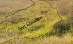
- The site has a water table <6 feet from the soil surface and is located in depressions on uplands or floodplains and drainageways.
- All other wet sites located in deep depressions and river valleys
-
i
Key Characteristics
- The site has a water table <6 feet from the soil surface and is located in depressions on uplands or floodplains and drainageways.
- Site has early growing season ponding, is typically located in depressions and floodplains, and is poorly drained
-
i
Key Characteristics
- All other sites
- Site is located on shoulder slopes, convex rises, and summits with strong to violent effervescence immediately below the surface layer
-
i
Key Characteristics
- All other sites
- Site located adjacent to a stream or river, occasional flooding
-
i
Key Characteristics
- Sand content is >45% in the surface texture
- Site is located on drainageways and stream terraces, and has rare to occasional flooding
-
i
Key Characteristics
- Bedrock and/or >15% of gravel is < 20 inches from soil surface
- Soil depth is 9-20 inches to bedrock
- Weathered sandstone bedrock
-
i
Key Characteristics
- Sand content is >45% in the surface texture
- Site is located on hills and ridges and are generally calcareous throughout soil profile
-
i
Key Characteristics
- All other sites
- All other sites
- Calcium carbonates occurring within 8 inches of soil surface
-


Ecological site map
Basemap
Find me
Find point
Full screen
Zoom in to display soil survey map units for an area of interest, and zoom out to display MLRAs. Select a map unit polygon to view ecological sites correlated to that map unit. View a brief description of an ecological site by clicking on its name in the map popup. Soil survey correlations may not be accurate, and ecological site classification of a location should always be verified in the field. Each selection may require the transfer of several hundred KB of data.
Ecological site keys
Ecological site photos
Print Options
Sections
Font
Other
Briefcase
Add ecological sites and Major Land Resource Areas to your briefcase by clicking on the briefcase (![]() ) icon wherever it occurs. Drag and drop items to reorder. Cookies are used to store briefcase items between browsing sessions. Because of this, the number of items that can be added to your briefcase is limited, and briefcase items added on one device and browser cannot be accessed from another device or browser. Users who do not wish to place cookies on their devices should not use the briefcase tool. Briefcase cookies serve no other purpose than described here and are deleted whenever browsing history is cleared.
) icon wherever it occurs. Drag and drop items to reorder. Cookies are used to store briefcase items between browsing sessions. Because of this, the number of items that can be added to your briefcase is limited, and briefcase items added on one device and browser cannot be accessed from another device or browser. Users who do not wish to place cookies on their devices should not use the briefcase tool. Briefcase cookies serve no other purpose than described here and are deleted whenever browsing history is cleared.
Ecological sites
Major Land Resource Areas
The Ecosystem Dynamics Interpretive Tool is an information system framework developed by the USDA-ARS Jornada Experimental Range, USDA Natural Resources Conservation Service, and New Mexico State University.