Natural Resources
Conservation Service
Ecological site R054XY030ND
Shallow Loamy
Accessed: 11/23/2024
General information
Provisional. A provisional ecological site description has undergone quality control and quality assurance review. It contains a working state and transition model and enough information to identify the ecological site.

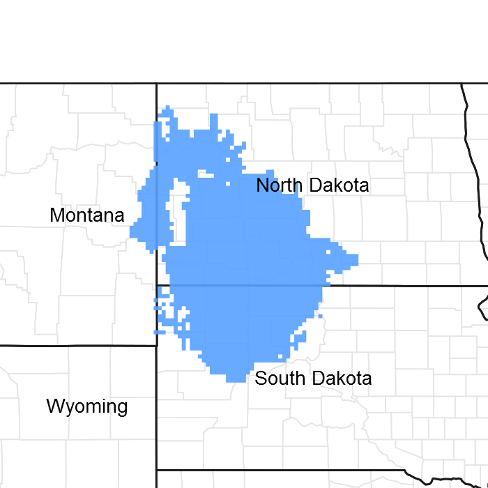
Figure 1. Mapped extent
Areas shown in blue indicate the maximum mapped extent of this ecological site. Other ecological sites likely occur within the highlighted areas. It is also possible for this ecological site to occur outside of highlighted areas if detailed soil survey has not been completed or recently updated.
Classification relationships
Level IV Ecoregions of the Conterminous United States: 43a – Missouri Plateau.
Associated sites
| R054XY031ND |
Loamy |
|---|---|
| R054XY035ND |
Very Shallow |
| R054XY038ND |
Thin Loamy |
Similar sites
| R054XY045ND |
Limy Sands [Moderately deep entisol, usually calcareous within 4 inches to the surface, found on knobs and/or sideslopes of hills and buttes; will not form a ribbon; up slope of sands or sandy and down slope from shallow sandy ecological sites. Indicator species: Little bluestem, sand bluestem, and prairie sandreed, along with penstemon, silverleaf scurfpea, purple coneflower, yucca, creeping juniper, and leadplant. This site has less western wheatgrass, plains muhly, green needlegrass and sideoats grama, more little bluestem, sedges, prairie sandreed and sand bluestem, more production, deeper soils, no restrictive layer above twenty inches.] |
|---|---|
| R054XY028ND |
Shallow Clayey [Some what excessively well drained soils more than 10 less than 20 inches to unweathered shales that restricts root penetration. Upslope of clayey site, surface layer will ribbon greater than 2 inches, upslope of clayey ecological site. Indicator species: western wheatgrass dominates with little bluestem, plains muhly and sideoats grama, gayfeather. This site has similar species but less little bluestem and sideoats, more plains muhly, green needlegrass, western wheatgrass, restrictive layer above twenty inches is shale, slightly less production.] |
| R054XY038ND |
Thin Loamy [Deep and moderately deep entisols, usually calcareous within 4 inches to the surface, found on knobs and/or sideslopes of hills and buttes. Will form a ribbon greater than 1 inches but not more than 2 inches. Up slope of loamy and down slope of thin loamy or shallow loamy ecological sites. Indicator species: western wheatgrass, little bluestem, plains muhly, porcupinegrass and sideoats grama, with Missouri goldenrod, dotted gayfeather, pasqueflower, purple coneflower and purple prairie clover, and shrubs like winterfat and prairie rose. This site has similar species but more western wheatgrass, porcupine-grass and/or green needlegrass, less little bluestem, plains muhly, blue grama and sideoats grama, more production, deeper soils, no restrictive layer above twenty inches.] |
| R054XY043ND |
Shallow Sandy [Some what excessively well drained soils more than 10 less than 20 inches to sedimentary sandstone bedrock and/or gravels that restricts root penetration. Surface layer will ribbon less than 1 inch unless above gravels than more than 1 but less than 2 inches. Upslope from thin loamy, limy sands, sands or sandy sites and some times down slope form very shallow ecological sites. Indicator species: little bluestem, prairie sandreed, sand bluestem, and needle grasses, with dotted gayfeather, pasqueflower, purple coneflower and purple prairie clover, and shrubs like prairie rose and yucca. This site has similar species but more little bluestem, sand bluestem, prairie sandreed and sedges, less plains muhly, green needlegrass, western wheatgrass, restrictive layer above twenty inches is sandstone or gravels, slightly more production.] |
| R054XY035ND |
Very Shallow [Excessively well drained soils less than 10 inches to scoria, gravels, shales, siltstone or sandstone bedrock that restricts root penetration, upslope of shallow clayey, shallow loamy or shallow sandy ecological sites. Indicator species are little bluestem, sideoats grama, blue grama, purple coneflower, pasqueflower and creeping juniper. This site has similar species but more needleandthread, blue grama and little bluestem, less plains muhly, green needlegrass, western wheatgrass, restrictive layer above 10 inches is scoria or gravels, less production.] |
| R054XY031ND |
Loamy [Does not receive additional moisture. Found on dry uplands upslope from loamy terraces or loamy overflow sites, down slope from thin loamy or shallow loam sites; similar landscape position as sandy, sands, clayey sites. Will ribbon greater than 1 inch and up to 2 inches. Indicator species are western wheatgrass some green needlegrass and blue grama, with fringed sagewort and western snowberry being the dominant shrubs. This site has more production, different landscape position, no restrictive layers above twenty inches, no little bluestem, plains muhly, and sideoats grama, more western wheatgrass and green needlegrass.] |
Table 1. Dominant plant species
| Tree |
Not specified |
|---|---|
| Shrub |
Not specified |
| Herbaceous |
(1) Schizachyrium scoparium |
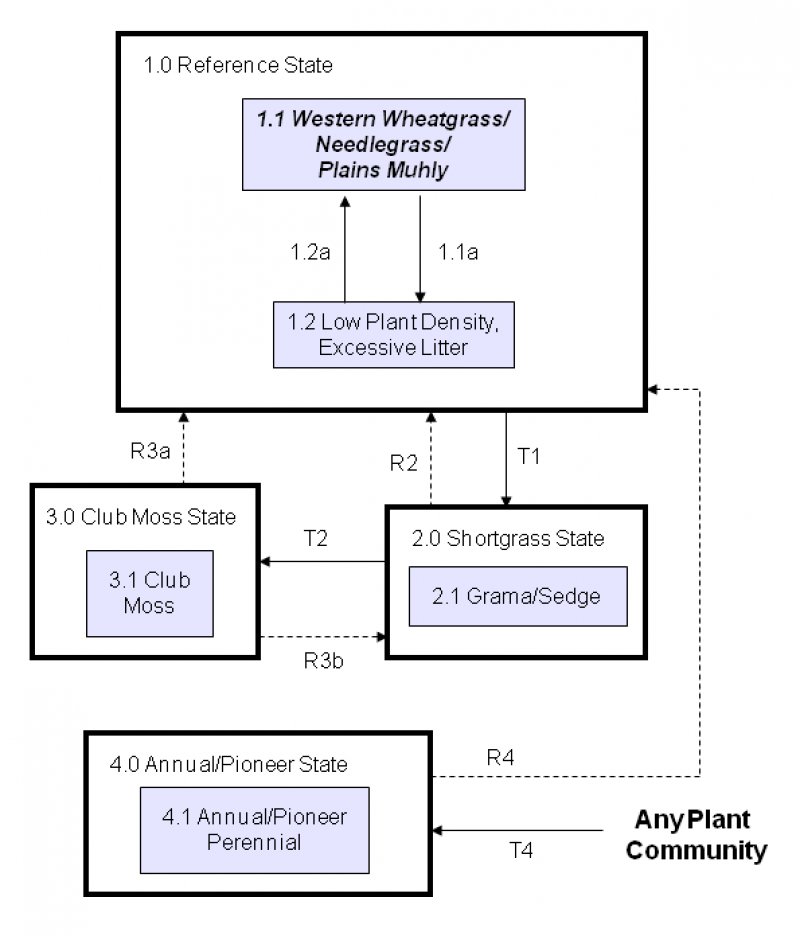
Click on box and path labels to scroll to the respective text.
