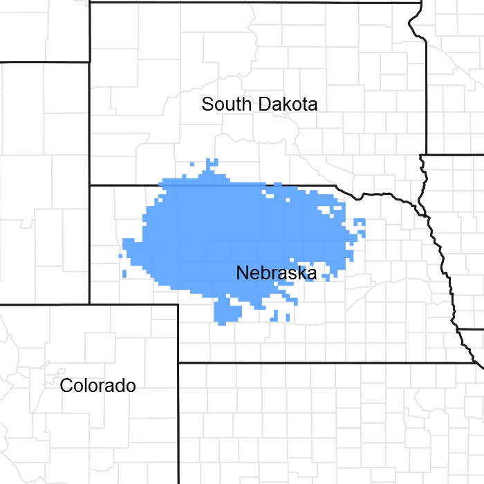
Ecological dynamics
Sandy Lowland ecological sites developed under Northern Great Plains climatic conditions, light to severe grazing by bison and other large herbivores, sporadic natural or man-caused fire, and other biotic and abiotic factors that typically influence soil and site development. This continues to be a disturbance-driven site with herbivory, fire, and variable climate being the primary disturbances. Changes occur in the plant communities due to short-term weather variations, impacts of native and exotic plant and animal species, and management actions. The Sandy Lowland ecological site is often a transitional area between Sandy and Subirrigated ecological sites, although abrupt transitions to a Sands ecological site can occur. The Sandy Lowland ecological site includes depressional areas, which allow deep-rooted native warm-season grasses to utilize subsurface moisture. This ability to utilize subsurface moisture, along with the plant diversity on the site, allows for high resistance to drought. The site is extremely resilient, and well adapted to Northern Great Plains climatic conditions.
The introduction of domestic livestock by European settlers along with season-long, continuous grazing and annual late summer haying had a profound impact on the vegetation of the Sandy Lowland ecological site. Season-long, continuous grazing causes a repeated removal of the growing point and excessive defoliation of the leaf area of the more palatable warm-season tallgrasses, reducing the ability of the plants to harvest sunlight thereby depleting root reserves and subsequently decreasing root mass. The ability of the plants to compete for nutrients is impaired, resulting in decreased vigor and eventual mortality. Species that evade negative grazing impacts through mechanisms such as a growing season adaptation (i.e., cool-season), growing points located near the soil surface, a shorter structure, or reduced palatability will increase. As this site deteriorates, species such as prairie sandreed, sand dropseed and blue grama initially increase while sand bluestem and switchgrass decrease in frequency and production. As the management continues, prairie sandreed will decrease and warm-season shortgrasses, cool season grasses, forbs will significantly increase. The Sandy Lowland site can become dominated by native cool-season grasses and the site is susceptible to invasion by non-native cool-season grasses. In the absence of fire and woody species management this site is also susceptible to encroachment by woody species, especially eastern red cedar.
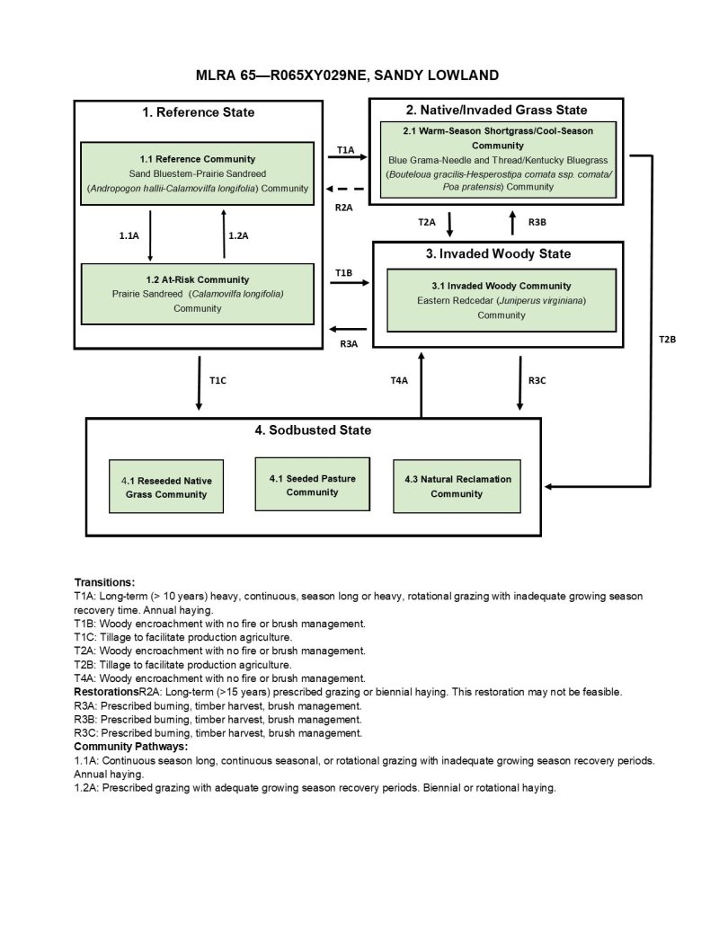
The State and Transition Model (STM is depicted below and includes a Reference State (1), a Native/Invaded Grass State (2), an Invaded Woody State (3), and a Sodbusted State (4). Each state represents the crossing of a major ecological threshold due to the alteration of the functional dynamic properties of the ecosystem. The primary properties observed to determine this change are soil stability, vegetative communities, and the hydrologic function. Each state may have one or more plant communities that fluctuate in species composition and abundance within the normal parameters of the state. Within each state, communities may degrade or recover in response to natural and man caused disturbances such as variation in the degree and timing of herbivory, presence or absence of fire, and local climatic fluctuations especially in the precipitation regime. The processes that cause the movement between the states and communities are discussed in more detail in the state and community descriptions following the model diagram.
Interpretations are primarily based on the Reference Community (1.1), which has been determined by study of rangeland relic areas, areas protected from excessive disturbance, and areas under long-term rotational grazing regimes. Trends in plant community dynamics ranging from heavily grazed to lightly grazed areas, seasonal use pastures, and historical accounts have been used as well. Plant communities, states, transitional pathways, and thresholds have been determined through similar studies and experience.
State 1
Reference State
The Reference State (1) describes the range of vegetative communities that occur on the Sands Lowland ecological site where the range of natural variability under historic conditions and disturbance regimes is mostly intact. The Reference State developed under the combined influences of climatic conditions, periodic fire activity, grazing by large herbivores, and impacts from small mammals and insects. High perennial grass cover and production allows for increased soil moisture retention, vegetative production and overall soil quality.
The Reference State includes two community phases which are the Reference Community (1.1) and the At-Risk Community. The Reference Community serves as a description of the native plant community that occurs on the site when the natural disturbance regimes are intact or closely mimicked by management practices. The At-Risk Community results from management actions that are unfavorable for a healthy Reference Community. In the absence of fire and brush management, this state is susceptible to encroachment by eastern redcedar.
Community 1.1
Reference Community
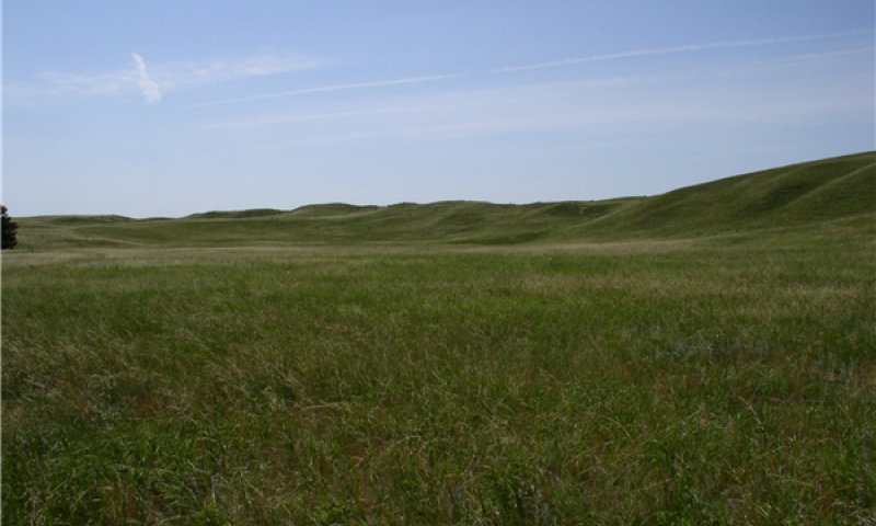
Figure 9. Reference Community (1.1), Sandy Lowland ecological site, MLRA 65.
Interpretations are primarily based on the Reference or Sand Bluestem-Prairie Sandreed (Andropogon hallii-Calamovilfa longifolia) Community (1.1). This plant community serves as a description of the native plant community that occurs on the site when the historic disturbance regimes are intact or are closely mimicked by management practices. This phase is dynamic, with fluid relative abundance and spatial boundaries between the dominant structural vegetative groups. These fluctuations are primarily driven by different responses of the species to changes in precipitation timing and abundance, and to fire and grazing events. This site developed with grazing by large herbivores and is well suited for grazing by domestic livestock.
This plant community consists chiefly of warm-season, tall- and midgrasses. Principle dominants are sand bluestem, prairie sandreed, switchgrass, and little bluestem. Grasses of secondary importance include Indiangrass, needle and thread, porcupinegrass, blue grama, and hairy grama. Sedges occur in the understory. The forb population is diverse. Leadplant, western sandcherry, and rose are common shrubs. The potential vegetative composition is 80 to 90 percent grasses and grass-likes, 5 to 10 percent forbs, and 1 to 10 percent shrubs by weight.
Natural fire played a significant role in the succession of this site by limiting the extent of shrubs. Wildfires have been actively controlled in recent times, facilitating tree and shrub encroachment. This plant community can be found on areas that are managed with prescribed grazing, prescribed burning, and may be found on areas receiving occasional periods of short-term rest.
This resilient community is well adapted to the Northern Great Plains climatic conditions. Plant diversity promotes strong tolerance to drought, site and soil stability, a functional hydrologic cycle, and a high degree of biotic integrity. These factors create a suitable environment for a healthy and sustainable plant community.
Table 5. Annual production by plant type
| Plant type |
Low
(lb/acre) |
Representative value
(lb/acre) |
High
(lb/acre) |
| Grass/Grasslike |
2260 |
2610 |
2925 |
| Forb |
140 |
220 |
325 |
| Shrub/Vine |
0 |
70 |
150 |
| Total |
2400 |
2900 |
3400 |
| Jan |
Feb |
Mar |
Apr |
May |
Jun |
Jul |
Aug |
Sep |
Oct |
Nov |
Dec |
| J |
F |
M |
A |
M |
J |
J |
A |
S |
O |
N |
D |
Community 1.2
At-Risk Community
The At-Risk or Prairie Sandreed (Calamovilfa longifolia) Community (1.2) develops with continuous season-long grazing, seasonal grazing, or rotational grazing with inadequate growing season recovery time. Most of the palatable plants of the Reference Community (1.1) are present and warm-season tallgrasses remain as a dominant component in the plant community but production from these grasses is reduced. Sand bluestem, little bluestem, and switchgrass are reduced while Indiangrass is significantly reduced or a absent from the plant community. As compared to the Reference Community, the At-Risk Community has a higher proportion of cool-season grasses and forbs. The reduction in desirable warm-season tallgrasses results in decreased production and reduces the community’s ability to improve production during favorable years.
Prairie sandreed is the dominant grass. Grasses of secondary importance include blue grama, hairy grama, needle and thread, sand dropseed, and western wheatgrass. The forb component is dominated by Cuman ragweed, white sagebrush, goldenrods, verbenas, and white heath aster. The potential vegetative composition is 75 to 85 percent grasses or grass-like plants, 5 to 15 percent forbs, and 5 to 10 percent shrubs.
The soil surface remains intact and erosion is low as evidenced by the lack of rills, waterflow patterns, or pedestalled plants. Infiltration and runoff have not increased due to the nature of the soil. This plant community is considered stable but is at risk if increased disturbance such as drought or overgrazing occurs; this risk increases significantly when drought and overgrazing are combined. The resiliency of this plant community is moderate depending on the intensity and duration of disturbance.
Grazing management that includes adequate growing season recovery time will move the plant community to the Reference Community while increased disturbance, such as drought or heavy grazing, will cause further loss of warm-season tall- and midgrasses and cause a transition to the Native/Invaded Grass State (2). The close proximity of Sand Lowland ecological sites to the Subirrigated ecological sites often leads to implementation of the same management scenarios for both sites. The lack of subsoil moisture on Sandy Lowland sites reduces the ability of the grasses to recover from annual haying resulting in lower plant health and vigor. Biennial haying on the Sandy Lowland sites combined with annual fall grazing in conjunction with annual haying on Subirrigated sites is a management alternative that will maintain the plant community in the Reference State. Fencing along ecological site boundaries provides additional management options for both Subirrigated and Sandy Lowland sites and should be considered if adequate water facilities are present.
| Jan |
Feb |
Mar |
Apr |
May |
Jun |
Jul |
Aug |
Sep |
Oct |
Nov |
Dec |
| J |
F |
M |
A |
M |
J |
J |
A |
S |
O |
N |
D |
Pathway 1.1A
Community 1.1 to 1.2
Continuous season-long grazing, continuous seasonal grazing in the summer, or rotational grazing with inadequate recover periods will convert the Reference Community (1.1) to the At-Risk Community (1.2). Continuous heavy grazing tends to accelerate this movement. Annual haying will also cause this shift.
Pathway 1.2A
Community 1.2 to 1.1
Prescribed grazing with adequate recovery periods will return the At-Risk Community to the Reference Community. When the land is managed as native hayland, biennial or rotational haying will move the community to the Reference Community.
State 2
Native/Invaded Grass State
The Native/Invaded Grass State (2) transitioned from the Reference State (1) and much of the native warm-season tall- and midgrass components have been replaced by warm-season shortgrasses and cool-season grasses. The Native/Invaded Grass State develops with long term grazing management that did not provide adequate recovery time for warm-season tall- and midgrasses. Non-native cool-season grasses are often present in the plant community and may become subdominant. The management that results in the Native/Invaded Grass State is typically heavy continuous season long grazing but heavy rotational grazing with inadequate growing season recovery periods can also cause this transition. Repeated annual haying during the rapid growth period of warm-season tallgrasses with inadequate growing recovery periods will also cause this transition over time.
The loss of warm-season tall- and midgrasses negatively impacts energy flow and nutrient cycling and alters hydrologic function. Plant litter is decreased. Infiltration is lower than in the Reference State. Return to the Reference State will take a significant amount of time and if adequate amounts of warm-season tall- and midgrasses are not present, restoration to the Reference State will not be feasible. The Native/Invaded Grass State is very resistant to change; however, eastern redcedar encroachment can quickly convert this state to the Invaded Woody State (3). The Native/Invaded Grass State includes the Warm-Season Shortgrass/Cool-Season Grass Community (2.1).
Community 2.1
Warm-Season Shortgrass/Cool-Season Grass Community
The Warm-Season Shortgrass/Cool-Season Grass or Blue Grama-Needle and Thread (Bouteloua gracilis-Hesperostipa comata) Community develops with heavy livestock grazing, usually season-long, or with annual haying followed by fall grazing. Deep rooted plants are replaced by shallow rooted, sod-forming grasses which tend to form root mats. This sod-bound condition reduces water infiltration. Forage production and plant species diversity has declined. Initially, the plant community will be a mosaic, with shortgrass and mixed grass communities intermingled but as the management continues the plant community becomes dominated by warm-season shortgrasses and cool-season grasses. Non-native grasses such as Kentucky bluegrass encroach into the community and may become subdominant. Small, isolated plants may exist in a prostrate form to avoid defoliation.
Blue grama, hairy grama, needle and thread, and sand dropseed are the dominant grasses. Other grasses or grass-likes include annual brome, Kentucky bluegrass, prairie junegrass, Scribner panicum, western wheatgrass, and sedges. Dominant forbs include Cuman ragweed, verbena, white sagebrush, thistle, and white heath aster. Sand sagebrush increases significantly in the western portion of the MLRA, while cactus and rose increase in the central and eastern portions of the MLRA. Annual haying delays the increase of sand sagebrush and rose but increases the cactus component in this community. The potential vegetative composition is 75 to 85 percent grasses and grass-likes, 5 to 10 percent forbs and 10 to 15 percent shrubs.
This plant community is fairly resistant to change, but the low species diversity makes the community vulnerable to heavy disturbance events like drought or hailstorms. Soil erosion is low. The hydrologic cycle is negatively impacted due to the lack of surface litter, increased runoff, and the reduced water infiltration. However, due to the soil texture, the impact to runoff and infiltration is moderate.
| Jan |
Feb |
Mar |
Apr |
May |
Jun |
Jul |
Aug |
Sep |
Oct |
Nov |
Dec |
| J |
F |
M |
A |
M |
J |
J |
A |
S |
O |
N |
D |
State 3
Invaded Woody State
The Invaded Woody State (3) is the result of woody encroachment. Once the tree canopy cover reaches 15 percent with an average tree height exceeding five feet, the threshold to the Invaded Woody State has been crossed. Woody species are increasing due to the lack of prescribed fire, brush management, or other woody tree removal. Typical ecological impacts are a loss of native grasses, reduce diversity of functional and structural groups, reduced forage production, and reduced soil quality. Prescribed burning, wildfire, timber harvest and brush management will move the Invaded Woody State toward a grass dominated state. If the Invaded Woody State transitioned from Native/Invaded Grass State (2) or the Sodbusted State (3), the land cannot return to the Reference State (1) as the native plant community, soils, and hydrologic function had been too severely impacted prior to the woody encroachment to allow the return to the Reference State through woody species removal alone. The Invaded Woody State includes one community, the Invaded Woody Community (3.1).
Community 3.1
Invaded Woody Community
The Invaded Woody Community or Eastern Redcedar (Juniperus virginiana) Community (3.1) has at least 15 percent canopy cover consisting of trees generally 5 feet or taller. Encroaching trees are primarily eastern redcedar. Additional woody cover from deciduous trees and shrubs may be present. In the absence of fire and brush management, this ecological site is very susceptible to eastern redcedar seedling invasion, especially when adjacent to a seed source. Eastern redcedar can eventually dominate the site resulting in a closed canopy monoculture which drastically reduces forage production, and which has limited value for either livestock grazing or wildlife habitat. With long-term fire suppression, this plant community will develop extensive ladder fuels which can lead to a removal of most tree species with a wildfire. With properly managed intensive grazing, encroachment of deciduous trees will typically be minimal; however, this will not impact encroachment of coniferous species. The herbaceous component decreases proportionately in relation to the percent canopy cover, with the reduction being greater under a
coniferous overstory.
Eastern redcedar control can usually be accomplished with prescribed burning while the trees are six feet tall or less and fine fuel production is greater than 1,500 pounds per acres. Larger red cedars can also be controlled with prescribed burning, but successful application requires the use of specifically designed ignition and holding techniques (https://www.loesscanyonsburning group.com). Resprouting brush must be chemically treated immediately after mechanical removal to achieve effective treatment. The forb component will initially increase following tree removal. To prevent return to a woody dominated community, ongoing brush management such as hand cutting, chemical spot treatments, or periodic prescribed burning is required.
This plant community is resistant to change and resilient given normal disturbances. In higher canopy cover situations, the soil erosion will increase in relation the plant community from which this plant community originated. The hydrologic function is also significantly altered under higher canopy cover. Infiltration is reduced and runoff is typically increased due to the lack of herbaceous cover and the rooting structure provided by the herbaceous species. Total annual production during an average year varies significantly, depending on the production level prior to encroachment and the percentage of canopy cover.
State 4
Sodbusted State
The threshold to the Sodbusted State (4) is crossed as a result of mechanical disturbance to facilitate production agriculture. If farming operations are suspended, the site can be seeded to native grasses and forms resulting in the Reseeded Native Grass Community (4.1), be seeded to a tame pasture forage mixture resulting in the Seeded Pasture Community (4.2) or be abandoned with no seeding which will result in the Natural Reclamation Community (4.3). Permanent alterations of the soil, plant community, and hydrologic cycle make restoration to the Reference State (1) extremely difficult, if not impossible.
Community 4.1
Reseeded Native Grass Community
The Reseeded Native Grass Community (4.1) does not contain native remnants, and varies considerably depending upon the seed mixture, the degree of soil erosion, the age of the stand, fertility management, and past grazing management.
Native rangeland and grasslands seeded to native species are ecologically different and should be managed separately. Factors such as functional group, species, stand density, and improved varieties all impact the production level and palatability of the seedings. Species diversity is often limited, and when grazed in conjunction with native rangelands, uneven forage utilization may occur.
Total annual production during an average year varies significantly depending upon precipitation, management, and grass species seeded. Prescribed grazing including appropriate utilization levels, adequate growing-season recovery periods, and timing of grazing that favor the productivity, health, and vigor of the seeded species is required to maintain this community. Periodic prescribed burning and brush management may also be needed.
Community 4.2
Seeded Pasture Community
The Seeded Pasture Community (4.2) does not contain native remnants and varies considerably depending upon the extent of soil erosion, the species seeded, the quality of the stand that was established, the age of the stand, and management of the stand since establishment.
There are several factors that make seeded tame pasture a different grazing resource than native rangeland and land seeded to a native grass mixture. Factors such as species selected, stand density, improved varieties, and harvest efficiency all impact production levels and palatability. Species diversity on seeded tame pasture is often limited to a few species. When seeded pasture and native rangelands or seeded pasture and seeded rangeland are in the same grazing unit, uneven forage utilization will occur. Improve forage utilization and stand longevity by managing this community separately from native rangelands or land seeded to native grass species.
Total annual production during an average year varies significantly depending on the level of management and species seeded. Improved varieties of warm-season or cool-season grasses are recommended for optimum forage production. Fertilization, weed management, and prescribed grazing including appropriate utilization levels, adequate growing-season recovery periods, and timing of grazing that favor the productivity, health, and vigor of the seeded species are required to maintain this community. Periodic prescribed burning and brush management may also be needed.
Community 4.3
Natural Reclamation Community
The Natural Reclamation Community (6.3) consists of annual and perennial early successional species. Perennial threeawns, sand dropseed, and annual grasses are common species. These sites have been farmed and abandoned without being reseeded. Soil organic matter and carbon reserves are reduced, soil structure is changed, and a plowpan or compacted layer can form, which decreases water infiltration. Residual synthetic chemicals may remain from farming operations. In early successional stages, this community is not stable. The hazard of erosion is a resource concern. Total annual production during an average year varies significantly depending on the succession stage of the plant community and any management applied to the system.
Transition T1A
State 1 to 2
The Reference State (1) transitions to the Native/Invaded Grass State (2) in response to long-term (greater than ten years), heavy, repeated defoliation of the key forage species by grazing or haying. This change typically occurs with long-term heavy, continuous season long grazing but heavy rotational grazing without adequate recovery periods may also cause this transition. Annual haying at the same time each year will also facilitate this change. Once the Reference State loses a significant proportion of warm-season, tall- and midgrasses it crosses a threshold to the Native/Invaded Grass State.
Transition T1B
State 1 to 3
Long-term (more than ten years) disruption of the natural fire regime and the encroachment of invasive exotic and native woody species with no woody species management can cause the Reference State (1) to transition to the Invaded Woody State (3).
Transition T1C
State 1 to 4
The Reference State (1) has been significantly altered by tillage to facilitate production agriculture. When the land is no longer cropped, the resulting state is the Sodbusted State (4). The disruption to the plant community, the soil, and the hydrology of the system prevent restoration to the Reference State.
Restoration pathway R2A
State 2 to 1
Long-term (more than 15 years) prescribed grazing with adequate growing season recovery periods will move the Native/Invaded Grass State (2) toward the Reference State (1). When the land is used for hay production, biennial haying may facilitate this restoration. The amount of time required for restoration, and feasibility of this restoration depends upon the abundance of warm-season tall- and midgrasses remaining in the plant community. This restoration may not be feasible.
Transition T2A
State 2 to 3
Long-term (more than ten years) disruption of the natural fire regime and the encroachment of invasive exotic and native woody species with no woody species management can cause the Native/Invaded Grass State (2) to transition to the Invaded Woody State (3).
Transition T2B
State 2 to 4
The Native/Invaded Grass State (2) has been significantly altered by tillage to facilitate production agriculture. When the land is no longer cropped, the resulting state is the Sodbusted State (4). The disruption to the plant community, the soil, and the hydrology of the system prevent restoration to the Native/Invaded Grass State.
Restoration pathway R3A
State 3 to 1
The Invaded Woody State (4) can be restored to the Reference State (1) through prescribed burning, wildfire, timber harvest, or brush management. The forb component may initially increase following tree removal. Ongoing brush management such as hand cutting, chemical spot treatments, or periodic prescribed burning is required to prevent a return to the Invaded Woody State. The heavier the existing canopy cover, the greater the energy input required to return to the Reference State by management practices. The amount of time required for this restoration to occur depends on the severity and duration of the encroachment. To maintain the site as grassland, maintenance burns will need to be conducted periodically to mimic the historical fire frequency of Sandhills grasslands.
Land that transitioned to the Invaded Woody State from the Native/Invaded Grass State (2) or the Sodbusted State (4) cannot be restored to the Reference State through the removal of woody species as the native plant community, soils, and hydrologic function have been too severely impacted for that restoration to occur with woody species removal alone.
Restoration pathway R3B
State 3 to 2
The Invaded Woody State (4) can be restored to the Native/Invaded Grass State (2) through prescribed burning, wildfire, timber harvest, or brush management. The forb component may initially increase following tree removal. Ongoing brush management such as hand cutting, chemical spot treatments, or periodic prescribed burning is required to prevent a return to the Invaded Woody State. The heavier the existing canopy cover, the greater the energy input required to return to the Native/Invaded Grass State. To maintain the site as grassland, maintenance burns will need to be conducted periodically to mimic the historical fire frequency of Sandhills grasslands.
Land that transitioned to the Invaded Woody State from the Native/Invaded Grass State or the Sodbusted State (4) cannot be restored to the Reference State (1) through the removal of woody species as the native plant community, soils, and hydrologic function have been too severely impacted for that restoration to occur with woody species removal alone.
Restoration pathway R3C
State 3 to 4
The Invaded Woody State (4) can be restored to the Sodbusted State (4) through prescribed burning, wildfire, timber harvest, or brush management. The forb component may initially increase following tree removal. Ongoing brush management such as hand cutting, chemical spot treatments, or periodic prescribed burning is required to prevent a return to the Invaded Woody State. The heavier the existing canopy cover, the greater the energy input required to return to the Sodbusted State by management practices. To maintain the site as grassland, maintenance burns will need to be conducted periodically to mimic the historical fire frequency of Sandhills grasslands.
Land that transitioned to the Invaded Woody State from the Native/Invaded Grass State (2) or the Sodbusted State cannot be restored to the Reference State (1) through the removal of woody species as the native plant community, soils, and hydrologic function have been too severely impacted for that restoration to occur with woody species removal alone.
Transition T4A
State 4 to 3
Long-term (more than ten years) disruption of the natural fire regime and the encroachment of invasive exotic and native woody species with no woody species management can cause the Sodbusted State (4) to transition to the Invaded Woody State (3).