Ecological dynamics
The information presented in this ecological site description (ESD) and state-and-transition model (STM) were developed using archaeological and historical information, published and unpublished scientific reports, professional experience, consultation with technical experts, and NRCS inventories and studies. The information presented represents a complex set of plant community dynamic and environmental variables. Not all scenarios or plants are represented and included. Key indicator plants, animals, and ecological processes are described to help guide land management decisions and actions. This concept contains broad concepts of marshes and prairies due to this area being unmapped, and will be subject to change as NOTCOM mapping is completed.
The vegetation consists of herbaceous or successional shrubby palustrine wetland communities found within drainageways and depressions, and trees if present, are very sparse and often stunted due to extended hydroperiods. Small outcrops of weathered limestone may be present in this community contributing to the karst topography of South Florida. This site consists of two separate vegetative states, Prairies and Bogs, and Freshwater Marshes. In the Big Cypress region, it is more typical for prairies to be dominant due to higher elevations (10 to 20 foot elevation changes) compared to the Everglades region where Marshes are dominant. Longer hydroperiods (>6 months) creates an anaerobic soil environment in which the breakdown of organic material is impeded, and sediments from dead vegetation continually accumulate, forming the characteristic peat soil.
Periphyton, or cyanobacteria, is found in both prairies and marshes. Not only are they primary producers, using photosynthesis to grow and create oxygen, but are important to the food web, being consumed by snails, frogs, aquatic insects, and fish. When periphyton conducts photosynthesis, it consumes acids in the water column. Since there is less acid, the pH of the water increases. This increase in pH causes dissolved calcium in the water to solidify on the surface of periphyton, other plants, or rocks. It is calcium that gives periphyton its gray or yellow-brown color. During the dry season, the organic material in the periphyton is eaten, but the calcium remains behind. Over time, this calcium builds up on the ground and creates a soil that is called marl (also called calcitic mud) (NPS, 2020). These organisms serve as natural and historic indicators of this ecosystem’s health. They are easily affected by changes in the environment, and if nutrient levels such as phosphorus become too high, they are outcompeted by cattails (Typha spp.), as well as remaining in the soil profile which can show historical water and nutrient conditions.
Prairies and Bog are characterized by a shorter hydroperiod (3 to 6 months) and is typically dominated by hydrophytic grasses and sedges along vast open expanses. These are continuously wet but not inundated soils on slightly higher elevations than marshes and have somewhat flat or gentle slopes. The main drivers in this community consist of extended hydroperiods and frequent fire regimes, relying on short fire return intervals of 1 to 3 years to maintain its grass and shrub community. Increases in long term hydroperiods can transition a prairie into a freshwater marsh by shifting species composition to more hydrophytic species and accumulating organic matter.
Freshwater Marshes are characterized by a longer hydroperiod (>6 months) and is dominated by grasses, sedges, broadleaf emergent, floating aquatics, or shrubs. Marshes occur at the lowest point in the landscape and are bordered by wet communities such as prairies, pine flatwoods, and forested wetlands. These are all freshwater communities that are maintained as herbaceous communities against woody invasion by hydrologic fluctuations or by fire or both. Species composition usually is heterogeneous and forms along different zones related to length of hydroperiod and depth of flooding. Marshes frequently grades into wet prairies and in further regions south where marl is present, into marl prairies. Physical disturbances such as hog rooting, livestock, and off road vehicles pose a threat to these communities, destroying native species and churning the soil allowing invasive species to take hold. Hydrological increases can increase nutrient load allowing Typha species to become dominant, whereas drying of the marshes can allow transitions back to prairies, or if drawn down enough for pasture grasses to be grown, converting to pastureland.
State 1
Prairies and Bogs
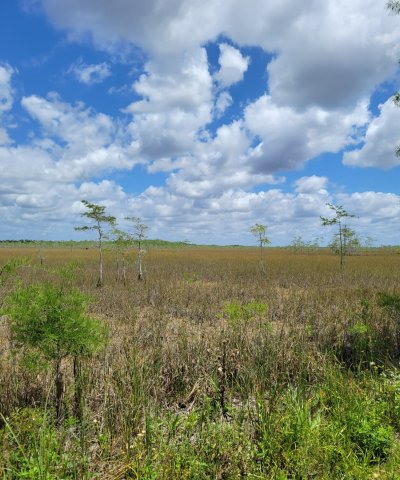
Figure 11. Prairie system within Big Cypress National Preserve. Stunted trees like these cypress may be present in this state.
This state is characterized by a short hydroperiod (3 to 6 months) and is typically dominated by hydrophytic grasses and sedges along vast open expanses. These are continuously wet but not constantly inundated soils on slightly higher elevations than marshes. These areas will hold shallow water during the wet season. The main drivers in this community consist of hydrology and fire regimes, relying on short fire return intervals of 1 to 3 years to maintain its grass and shrub community.
Characteristics and indicators. This site is characterized by dominant herbaceous and grass cover on continuously wet but not continuously inundated soils. They occupy vast open expanses and have a high diversity of species. In areas where it has been hydrologically altered stunted trees may be present.
Resilience management. This community is maintained by natural stressors from hydrology and fire regimes. Continuous saturation of the soil allows for the emergence of hydrophytic grasses and herbs while preventing woody mesic species from growing. With short fire return intervals of every 1 to 3 years this community also is able to prevent the emergence and dominance of woody species.
Dominant resource concerns
Community 1.1
Wet Prairie

Figure 12. Wet Prairie in the Big Cypress National Preserve. Photo taken in April with no standing water yet, soil was saturated.
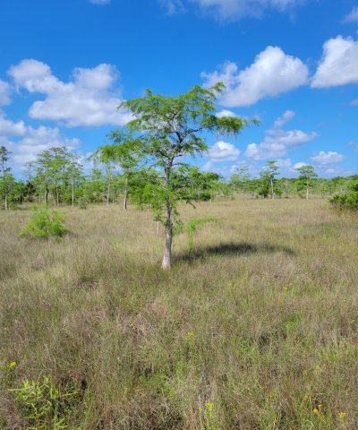
Figure 13. Stunted Cypress in Wet Prairie in Big Cypress National Preserve. These trees may be scattered throughout the prairies and often less than 20 feet in height.
Wet prairies are herbaceous communities found on continuously wet but not inundated soils on somewhat flat or gentle slopes between lower lying wet areas (i.e. marshes and swamps) and slightly higher drier areas (i.e. flatwoods and dry prairies). These prairies typically have a short hydroperiod and short fire return interval which help maintain community structure. These are very diverse understory communities that can become inundated to a very shallow depth during the wet season and occasionally have stunted trees. Within the Big Cypress National Preserve this includes wet prairies and cypress prairies.
Resilience management. This community is maintained by regular fire return intervals of every 2 to 3 years as well as continuously wet but rarely inundated soils. These stressors help maintain community structure and prevent the invasion of woody or undesirable species.
Dominant plant species
-
Florida slash pine (Pinus elliottii var. densa), tree
-
bald cypress (Taxodium), tree
-
cabbage palmetto (Sabal palmetto), tree
-
threeawn (Aristida), grass
-
beaksedge (Rhynchospora), grass
-
nutrush (Scleria), grass
-
yelloweyed grass (Xyris), grass
-
toothache grass (Ctenium aromaticum), grass
-
foxtail clubmoss (Lycopodiella alopecuroides), other herbaceous
-
yellow butterwort (Pinguicula lutea), other herbaceous
-
savannah meadowbeauty (Rhexia alifanus), other herbaceous
-
sundew (Drosera), other herbaceous
-
butterwort (Pinguicula), other herbaceous
-
bladderwort (Utricularia), other herbaceous
-
rayless goldenrod (Bigelowia), other herbaceous
-
pipewort (Eriocaulon), other herbaceous
-
water cowbane (Oxypolis filiformis), other herbaceous
Community 1.2
Marl Prairie
Marl Prairies are sparsely vegetated (20 to 40% cover) graminoid dominated communities found on marl substrates. Marl is often formed via periphyton, and is found both within the soil profile and as rocks scattered throughout the landscape. Like wet prairies, these are very diverse communities, but are often dominated in cover by one or two major species. Stunted scattered trees may be present within this community as well.
Resilience management. Marl prairies are maintained similar to wet prairies, by extended hydroperiods and frequent fire regimes. Marl prairies are able to hold water for several months out of the year while being shallowly inundated. Once they dry out during the winter they are subject to fires (every 2 to 3 years) which helps maintain community structure and prevent woody species from encroaching. Many of the diverse species require fire to stimulate flowering, and rapidly recover from fire effects.
Dominant plant species
-
bald cypress (Taxodium), tree
-
Florida slash pine (Pinus elliottii var. densa), tree
-
gulfhairawn muhly (Muhlenbergia filipes), grass
-
beaksedge (Rhynchospora), grass
-
little bluestem (Schizachyrium), grass
-
bogrush (Schoenus), grass
-
lovegrass (Eragrostis), grass
-
sand cordgrass (Spartina bakeri), grass
-
Jamaica swamp sawgrass (Cladium mariscus ssp. jamaicense), grass
-
panicgrass (Panicum), grass
-
gulfdune paspalum (Paspalum monostachyum), grass
-
arrowfeather threeawn (Aristida purpurascens), grass
-
rosy camphorweed (Pluchea rosea), other herbaceous
-
spiderlily (Hymenocallis), other herbaceous
-
yellowtops (Flaveria), other herbaceous
-
bladderwort (Utricularia), other herbaceous
-
pipewort (Eriocaulon), other herbaceous
Community 1.3
Shrub Bog
Shrub bogs consists of dense stands of broadleaf evergreen shrubs, vines, and short trees, with height dependent on time since fire, with or without an overstory of scattered pine or bay trees, growing in mucky soil where water is usually less than a foot deep. These communities become formed when fire is excluded from the reference communities for a long period of time (estimated 12 to 15 years), which allow for the establishment of woody species. Fires tend to extinguish themselves from this community, and are often found adjacent to freshwater marshes or other wetlands. The larger the shrub species are the longer without fire this community has gone.
Resilience management. This community is maintained by the absence of fire within a community which allows for the establishment of organic matter accumulation and shrub growth. Excluding fire from this community maintains this structure. When fires do occur in this community, it is during periods of extreme drought (estimated every 10 to 20 years), in which the shrubs are able to re-sprout rapidly.
Dominant plant species
-
Florida slash pine (Pinus elliottii var. densa), tree
-
pond cypress (Taxodium ascendens), tree
-
red maple (Acer rubrum), tree
-
fetterbush lyonia (Lyonia lucida), shrub
-
large gallberry (Ilex coriacea), shrub
-
inkberry (Ilex glabra), shrub
-
wax myrtle (Morella cerifera), shrub
-
Virginia sweetspire (Itea virginica), shrub
-
myrtle dahoon (Ilex myrtifolia), shrub
-
sweetbay (Magnolia virginiana), shrub
-
swamp bay (Persea palustris), shrub
-
greenbrier (Smilax), other herbaceous
-
pipewort (Eriocaulon), other herbaceous
-
leatherfern (Acrostichum), other herbaceous
-
airplant (Tillandsia), other herbaceous
-
sphagnum (Sphagnum), other herbaceous
Pathway 1.1A
Community 1.1 to 1.3
In prairies that are surrounded by pyrogenic uplands, the absence of fire from the wet prairie and may allow for the introduction and establishment of woody species tolerant of extended hydroperiods. Alterations of the seasonal high-water table may allow for the introduction and establishment of woody species as well. Time since fire will be variable in individual prairies as they occur in landscapes occupied by fire-maintained matrix communities and will be dependent on the fire frequency of the surrounding matrix community. Decreases in the long-term hydroperiod will be less of a stressor for shrubby species and may accelerate the process. Decreases in the long-term hydroperiod may be caused directly through processes such as ditching and canal development, or indirectly through drawdown of the water table for surrounding land use conversion.
Pathway 1.2A
Community 1.2 to 1.3
In prairies that are surrounded by pyrogenic uplands, the absence of fire from the wet prairie and may allow for the introduction and establishment of woody species tolerant of extended hydroperiods. Alterations of the seasonal high-water table may allow for the introduction and establishment of woody species as well. Time since fire will be variable in individual prairies as they occur in landscapes occupied by fire-maintained matrix communities and will be dependent on the fire frequency of the surrounding matrix community. Decreases in the long-term hydroperiod will be less of a stressor for shrubby species and may accelerate the process. Decreases in the long-term hydroperiod may be caused directly through processes such as ditching and canal development, or indirectly through drawdown of the water table for surrounding land use conversion.
Pathway 1.3A
Community 1.3 to 1.1
This transition is driven by the removal of undesirable species and reestablishment of natural management strategies. Removal of undesirable hardwood species may be necessary to increase light availability to herbaceous groundcover and should be removed carefully to prevent disturbance to the surrounding community. Restoration and reestablishment of natural management strategies should include restoring the seasonal high-water table and ponding depths of the targeted reference community, which will assist in preventing further establishment of hardwood species that are less tolerant to extended hydroperiods. Return of the natural fire intervals are necessary to prevent reestablishment of hardwood species.
Pathway 1.3B
Community 1.3 to 1.2
This transition is driven by the removal of undesirable species and reestablishment of natural management strategies. Removal of undesirable hardwood species may be necessary to increase light availability to herbaceous groundcover and should be removed carefully to prevent disturbance to the surrounding community. Restoration and reestablishment of natural management strategies should include restoring the seasonal high-water table and ponding depths of the targeted reference community, which will assist in preventing further establishment of hardwood species that are less tolerant to extended hydroperiods. Return of the natural fire intervals are necessary to prevent reestablishment of hardwood species.
State 2
Freshwater Marshes

Figure 14. Freshwater Marsh System in the Big Cypress National Preserve.
Freshwater marshes occur at the lowest point in the landscape and are dominated by grasses, sedges, broadleaf emergents, floating aquatics, and shrubs throughout a vast open expanse. They are typically bordered by wet communities such as wet prairies, wet flatwoods, and cypress swamps; and can be found as isolated pockets within these other communities.
Characteristics and indicators. Freshwater marshes are characterized by long hydroperiods and open expanses of hydrophytic grasses, sedges, and herbaceous species. Species composition is usually heterogeneous and forms along different zones related to lengths of hydroperiod and depth of flooding or ponding.
Resilience management. This state can be maintained through proper hydrologic management and fire return intervals. Both frequent fire and extended hydroperiods play important parts in maintaining this state by keeping woody species excluded.
Dominant resource concerns
Community 2.1
Depression Marsh
This community often occurs as a shallow, usually rounded depression (concave - concave) in sand substrate with herbaceous vegetation or subshrubs, which forms in concentric bands due to slight changes in hydroperiods. This is considered the reference community for the freshwater marshes state because depression marshes can form as a part of a larger marsh community (i.e. glades marsh) or as an isolated marsh within an upland community. These marshes form when overlying sand slumps into depressions dissolved in underlying limestone bedrock. Peat usually accumulates towards the center, deepest portion, and have standing water for most of the year, while the outskirts are sandy substrates. Vegetation is formed in concentric bands, with the outer driest zones occupied by sparse herbaceous vegetation, moving towards the center of dense hydrophytic vegetation.
Resilience management. These marshes are often maintained through a high-water table and standing water in the wet season, and periodic fires in the dry season. The frequency of fire in depression marshes is a function of the fire frequency in the surrounding matrix community, as well as the fire-carrying characteristics of the marsh vegetation. Fire should be allowed to enter the community and extinguish itself naturally. Fire breaks separating a depression marsh from the surrounding community may allow for the invasion of shrubby species at the expanse of herbaceous species. A decrease in the fire frequency or long term hydroperiod or both may alter these communities to allow a transition to a shrub - scrub wetland.
Physical disturbances such as hog rooting and off-road vehicles can destroy native species and churn the soil, replacing native species with weedy invasive species. In depression marshes found surrounded by pastures, drawdown of the water table and soil compaction can allow pasture grasses to invade the marsh at the expanse of native species.
Forest understory. Depression marshes will form concentric bands of vegetation based off slight changes in the ponding hydroperiod and water depth. Depending on depth and configuration, depression marshes can have varying combinations of these zones and species within each zone.
The outer, or driest, zone is often occupied by sparse herbaceous vegetation consisting of longleaf threeawn (Aristida palustris), beaksedges (Rhynchospora microcarpa, R. cephalantha, R. tracyi, R. filifolia, etc.), Elliott’s yellow-eyed grass (Xyris elliottii), the subshrub, myrtleleaf St. John’s wort (Hypericum myrtifolium), and patches of blue maidencane (Amphicarpum muhlenbergianum) or sand cordgrass (Spartina bakeri).
This sparse zone may be followed downslope by a sparse to dense zone of peelbark St. John’s wort (Hypericum fasciculatum), water toothleaf (Stillingia aquatica) and scattered herbs, such as fringed yellow-eyed grass (Xyris fimbriata), pipeworts (Eriocaulon compressum and E. decangulare), narrowfruit horned beaksedge (Rhynchospora inundata), and Baldwin’s spikerush (Eleocharis baldwinii).
The innermost, deepest zone is occupied by maidencane (Panicum hemitomon), pickerelweed (Pontederia cordata), bulltongue arrowhead (Sagittaria lancifolia), or sawgrass (Cladium jamaicense). Floating-leaved plants, such as white waterlily (Nymphaea odorata), may be found in open water portions of the marsh, espically during the wet season when excessive surface water is present.
Dominant plant species
-
St. Johnswort (Hypericum), shrub
-
longleaf threeawn (Aristida palustris), grass
-
beaksedge (Rhynchospora), grass
-
yelloweyed grass (Xyris), grass
-
blue maidencane (Amphicarpum purshii), grass
-
sand cordgrass (Spartina bakeri), grass
-
Jamaica swamp sawgrass (Cladium mariscus ssp. jamaicense), grass
-
spikerush (Eleocharis), grass
-
pipewort (Eriocaulon), other herbaceous
-
maidencane (Panicum hemitomon), other herbaceous
-
pickerelweed (Pontederia cordata), other herbaceous
-
bulltongue arrowhead (Sagittaria lancifolia), other herbaceous
-
bent alligator-flag (Thalia geniculata), other herbaceous
-
waterlily (Nymphaea), other herbaceous
Community 2.2
Glades Marsh
Glades marsh are marshes in broad shallow channels or low-broad flats (concave- linear) over a substrate of peat or marl directly laying over limestone. They form due to near constant hydroperiods from up watershed sources and will support an open expanse of dominantly sawgrass (Cladium jamaisence), often growing 6 to 10 feet tall. This is a very flat open area, and is the dominant freshwater marsh type of the Everglades ecoregion. While most dominant in the Everglades, it is present within the Big Cypress ecoregion along the border of the Everglades ecoregion as well as further west inland.
Resilience management. Soils need to be saturated for 6 to 9 months or more during the year. Controlled fire during the wet season is needed to maintain community structure and composition.
Community 2.3
Sloughs
Sloughs are the deepest drainageways within swamps and marsh systems; and consist of broad channels inundated with slow moving or nearly stagnant water except during extreme droughts. They are formed by flowing water during floods and periods of heavy rainfall, and are considered shifting communities. Catastrophic peat fires create new sloughs while older, unburned sloughs fill in with peat over time, transitioning to freshwater marshes. This community is characterized by open water and emergent vegetation during the wet season and sparse grasses and herbaceous species during the dry season. Sloughs will often form as an interspersed matrix within the glades marsh system, as the low broad channels between the expansive sawgrass flats.
Resilience management. This community is a shifting community and while can be maintained via extended hydroperiods, will eventually change over time. Older sloughs can fill in with peat, decreasing their hydrologic flow and transitioning the slough to a glades marsh, whereas new sloughs are formed when peat fires create new open channels for water to flow in.
Dominant plant species
-
bald cypress (Taxodium), tree
-
common buttonbush (Cephalanthus occidentalis), shrub
-
Jamaica swamp sawgrass (Cladium mariscus ssp. jamaicense), grass
-
giant cutgrass (Zizaniopsis miliacea), grass
-
bent alligator-flag (Thalia geniculata), other herbaceous
-
bandanna of the Everglades (Canna flaccida), other herbaceous
-
pickerelweed (Pontederia cordata), other herbaceous
-
bulltongue arrowhead (Sagittaria lancifolia), other herbaceous
-
lizard's tail (Saururus cernuus), other herbaceous
-
waterlily (Nymphaea), other herbaceous
-
big floatingheart (Nymphoides aquatica), other herbaceous
-
yellow pond-lily (Nuphar lutea), other herbaceous
-
duckweed (Lemna), other herbaceous
-
bladderwort (Utricularia), other herbaceous
-
star orchid (Epidendrum), other herbaceous
-
butterfly orchid (Encyclia), other herbaceous
Pathway 2.2A
Community 2.2 to 2.3
Sloughs can be created within other marsh systems when peat fires occur. These can lower the landscape which allows water to pool and create a new slough habitat.
Context dependence. This happens typically during the dry season or during a drought, when there is no standing water and the peat layer is sufficiently dried enough to burn. Peat fires can low for a long time and smolder, continuously burning an area.
Pathway 2.3A
Community 2.3 to 2.2
As sloughs become very old, they can fill in with organic matter, causing a shift towards a freshwater marsh community. The marsh will most likely represent the surrounding community. As the slough becomes more shallower due to organic matter accumulation, it can support more vegetation adapted to longer hydroperiods such as sawgrass.
Context dependence. This is a very long process, and can take multiple centuries to achieve.
State 3
Invasive Non-Native Community
This state consists of Florida Department of Agriculture and Consumer Services (FDACS) Non-Native Category 1 Species list . More information on these species list can be found:
https://www.fdacs.gov/content/download/63140/file/Florida%E2%80%99s_Pest_Plants.pdf
or by contacting the UF / IFAS Center for Aquatic and Invasive Plants (http://plants.ifas.ufl.edu/),
the UF / IFAS Assessment of Non-native Plants in Florida's Natural Areas (https://assessment.ifas.ufl.edu/),
or the FWC Invasive Plant Management Section (http://myfwc.com/wildlifehabitats/invasive-plants/).
This community will not represent every possibility of invasive species but rather the most common in these areas.
Characteristics and indicators. Non-Native species include species that exist outside of Florida's natural range and introduced to the state by people, weather, or any other means.
Resilience management. This state can be found as a part of any other state and can completely destroy the native habitat if not properly managed. Restoration to natural communities after exotic invasion include practices such as mechanical and chemical removal.
Dominant resource concerns
-
Subsidence
-
Concentration of salts or other chemicals
-
Nutrients transported to surface water
-
Plant productivity and health
-
Plant structure and composition
State 4
Managed Resource Areas

Figure 15. Cattle and Donkey grazing in pasture converted from a freshwater non-forested wetland.
The following communities comprise the major land uses in the United States and the land uses receiving the majority of the conservation treatment that address soil, water, air, plant, and animal resources within the USDA.
Characteristics and indicators. These land uses consist of areas that are not completely naturalized (i.e. native habitat) but are not completely altered by anthropogenic means. Through alteration of the natural hydroperiod of an area and modification of the area they are able to support areas that produce valuable commodity products such as agriculture, improved pasture, etc.
Dominant resource concerns
-
Sheet and rill erosion
-
Wind erosion
-
Subsidence
-
Organic matter depletion
-
Concentration of salts or other chemicals
-
Seasonal high water table
-
Nutrients transported to surface water
-
Inadequate livestock shelter
Community 4.1
Rangeland
Rangelands are described as lands on which the indigenous vegetation (predominately grasses, grass-like plants, forbs, and possibly shrubs or dispersed trees) are managed for livestock grazing. Primary export from Florida ranges are cattle and have been present in the state since their first introduction by Spanish explorers in 1521. This is the reference community for this state because it requires very little alterations to the landscape for grazing species.
Rangelands provide a diversity of ecosystems and also provide a diverse and significant production of economic benefits and ecosystem goods and services. Livestock production along with sustainable wildlife populations provide for the major direct economic benefits, but also tourism, recreational uses, minerals/energy production, renewable energy, and other natural resource uses can be very significant. Vital ecosystem contributions include clean water, clean air, fish/wildlife habitat, as well as intangible considerations such as historical, cultural, aesthetic and spiritual values.
Resilience management. Grazing, by both domestic livestock and wildlife, is the most common ecological management process, with fire and weather extremes also being significant ecological factors. For information regarding specific cattle grazing techniques please contact your local NRCS office.
Community 4.2
Open Transitional Managed Communities
This is an area that is managed to maintain open land before shifting to another community. These communities are often used as transitional periods from one practice to another and could lead to an abandoned / fallow field.
Community 4.3
Improved Pasture
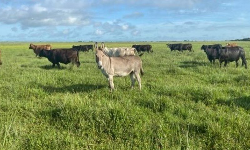
Figure 16. Cattle and Donkey grazing a pasture converted from a non-forested wetland in the Big Cypress ecoregion.
Pasture is a land use type having vegetation cover comprised primarily of introduced or enhanced native forage species that is used for livestock grazing. Pasture vegetation can consist of grasses, legumes, other forbs, shrubs or a mixture. The majority of these forages are introduced, having originally come from areas in other states or continents. Most are now naturalized and are vital components of pasture based grazing systems.
Pasture lands provide many benefits other than forage for livestock. Wildlife use pasture as shelter and for food sources. Well managed pasture captures rainwater that is slowly infiltrated into the soil which helps recharge groundwater. Many small pasture livestock operations are near urban areas providing vistas for everyone to enjoy.
Resilience management. Pastures receive periodic renovation and cultural treatments such as tillage, fertilization, mowing, weed control, and may be irrigated. For more information regarding specific pasture management please contact your local NRCS office.
Community 4.4
Agriculture
The agriculture industry includes cultivated crops, aquaculture, and apiculture. Cultivated cropland includes areas used for the production of adapted crops for harvest. These areas comprises land in row crops or close-grown crops that are in a rotation with row or close-grown crops. Primary export from Florida consists of fruits, greenhouse and nursery products, sugar cane, and the signature export of citrus. Aquaculture includes the cultivation and maintenance of aquatic plants, aquatic reptiles, crustaceans, food/ ornamental fish, shellfish, and other miscellaneous species for harvesting. Apiculture includes the maintenance of honeybees and hives to provide beeswax, honey/ other edible bee products, crop pollination services, and sales of bees to other beekeepers. These areas have been modified resulting in land clearing practices and hydrologic management to fit the growers needs.
Resilience management. Major natural resource concerns facing cropland include: (1) erosion by wind and water, (2) maintaining and enhancing soil quality, (3) water quality from nutrient and pesticides runoff and leaching, and (4) managing the quantity of water available for irrigation. For more specific information regarding cropland please contact your local NRCS office.
Community 4.5
Silviculture
Silviculture is land used in controlling the establishment, growth, composition, health, and quality of forests and woodlands to meet the diverse needs and values of landowners and society such as wildlife habitat, timber, water resources, restoration, and recreation on a sustainable basis. These are forestry practices that include thinning, harvesting, planting, pruning, prescribed burning and site preparation, for managed goals such as wildlife habitat creation or harvesting. Many managed silvicultural lands in Florida include tree plantations for growth of tropical ornamental species such as palms; and lumber, pulp, and paper species such as slash pine, longleaf pine, cypress, and eucalyptus.
This community also include management practices of agroforestry, the intentional mixing
of trees and shrubs into crop and/or animal production systems to create environmental, economic and social benefits. This is included in this community and not any other state because the primary management is for tree species. This may include practices such as riparian forest buffers, windbreaks, forest farming, silvopasture, and alley cropping.
Resilience management. Management of silvicultural lands require specific prescriptions based on the management goals for the stand, and may include thinning, harvesting, planting, pruning, prescribed burning and site preparation. For more information regarding specific management for silviculture practices please contact your local NRCS office.
Pathway 4.1A
Community 4.1 to 4.2
This pathway is driven by land clearing practices that consists of removing the existing vegetation from the habitat and altering the habitat to prepare for modified land use.
Pathway 4.2A
Community 4.2 to 4.1
This pathway is driven by the restoration of the native habitat for the use of rangeland. This includes restoration of both the hydrology and landscape in advance of replanting native species. This is a time-consuming process and often results in second-hand community structure. Once restored to a natural capacity the introduction of grazing species to the system creates a managed rangeland.
Pathway 4.2B
Community 4.2 to 4.3
This pathway is driven by preparing the land for pasteurization. This includes the planting of vegetation consisting of grasses, legumes, other forbs, shrubs or a mixture that will provide preferred forage for managed grazing species.
Pathway 4.2C
Community 4.2 to 4.4
This pathway is driven by the preparation of land for agricultural uses. This change is dependent on the type of agricultural community is being created, but often depends on the growing, maintenance, and cultivation of an agricultural product for consumers. This community may require modification to the land to fit the hydrologic requirement of the growing crop.
Pathway 4.2D
Community 4.2 to 4.5
This pathway is driven by the preparation of the land for silvicultural purposes. This change is dependent on the type of silvicultural product being cultivated, as many different practices require different growth requirements.
Pathway 4.3A
Community 4.3 to 4.2
This pathway is driven by land clearing practices that consists of removing the existing vegetation from the habitat and altering the habitat to prepare for modified land use.
Pathway 4.3B
Community 4.3 to 4.4
This pathway is driven by the preparation of land for agricultural uses. This change is dependent on the type of agricultural community is being created, but often depends on the growing, maintenance, and cultivation of an agricultural product for consumers. This community may require modification to the land to fit the hydrologic requirement of the growing crop.
Pathway 4.3C
Community 4.3 to 4.5
This pathway is driven by the preparation of the land for silvicultural purposes. This change is dependent on the type of silvicultural product being cultivated, as many different practices require different growth requirements.
Pathway 4.4A
Community 4.4 to 4.2
This pathway is driven by land clearing practices that consists of removing the existing vegetation from the habitat and altering the habitat to prepare for modified land use.
Pathway 4.4B
Community 4.4 to 4.5
This pathway is driven by the preparation of the land for silvicultural purposes. This change is dependent on the type of silvicultural product being cultivated, as many different practices require different growth requirements.
Pathway 4.5A
Community 4.5 to 4.2
This pathway is driven by land clearing practices that consists of removing the existing vegetation from the habitat and altering the habitat to prepare for modified land use.
State 5
Human Altered and Human Transported Areas
These areas include soils that were intentionally and substantially modified by humans for an intended purpose, commonly for terraced agriculture, building support, mining, transportation, and commerce. The alteration is of sufficient magnitude to result in the introduction of a new parent material (human-transported material) or a profound change in the previously existing parent material (human-altered material). They do not include soils modified through standard agricultural practices or formed soils with unintended wind and water erosion. When a soil is on or above an anthropogenic landform or microfeature, it can be definitely associated with human activity and is assigned to a unique taxa, usually found as an "Urban land complex" within that communities' natural soil properties (e.g., Immokalee sand-Urban land complex, 0 to 2 percent slopes).
Characteristics and indicators. Evidence of these areas include soils with manufactured items (e.g. artifacts) present in the profile, human altered-materials (e.g., deeply excavated or deeply plowed soil) or human-transported material (e.g., fill), and position on or above anthropogenic landforms (e.g., flood-control levees) and microfeatures (e.g., drainage ditches). Detailed criteria regarding the identification of anthropogenic (artificial) landforms, human-altered materials, and human-transported material are in the "Keys to Soil Taxonomy" (Soil Survey Staff, 2014).
Dominant resource concerns
-
Compaction
-
Ponding and flooding
-
Seasonal high water table
-
Emissions of greenhouse gases (GHGs)
-
Plant productivity and health
-
Plant structure and composition
Community 5.1
Reclaimed Areas
Reclaimed areas are areas that have been modified through anthropogenic means that are restored to a natural or second-hand natural community. Areas that can be reclaimed are any intensity urban areas, and may be required to be reclaimed after urban use (e.g., active mines must be reclaimed). These practices include the identification, removal, and stockpiling soil materials before altering the land, and revegetation and replacement of soil materials after altering the land. This also applies to nearby urban areas that have been adversely affected by the anthropogenic activities.
Community 5.2
Urban
This urban community consists of development for human use. Urban areas include a variety of land uses, e.g., inner city or urban core, industrial and residential areas, cemeteries, parks, and other open spaces; the overall function which may benefit the quality of human life. These often form an urban soil mosaic, where the natural landscape has been fragmented into parcels with distinctive disturbance and management regimes and, as a result, distinctive characteristic soil properties.
Resilience management. Within this community there are three different levels of urbanization, based off population dynamics, residential density, and intensity of development. These are labeled as low-intensity, medium-intensity, and high-intensity urban areas, which can eventually be split apart into its own separate state. Low-intensity urban areas may consist of single dwelling homes with little impact on the surrounding community which still somewhat represents the natural community (e.g., represents natural landscape, hydrology, and vegetation) , other examples of this are urban parks, cemeteries, or campgrounds with little urban development. Medium-intensity urban areas consist of larger urban dwellings with some natural features, but have been modified to meet urban needs (e.g., towns). High-intensity urban areas are areas of heavily modified areas with complete alterations of the natural landscape, hydrology, and vegetation to support a very large population, which once constructed is permanently altered (e.g., metropolis areas/ active mines).
Community 5.3
Non-Reclaimed Areas
Non-reclaimed areas are areas that have been modified through anthropogenic means that are unable to be restored to a natural or second-hand natural community. Areas that cannot be reclaimed are areas under active mining status or mined areas before the Phosphate Land Reclamation Act in 1975, which leaves shut down operations alone. These areas also include fallow mines that have been flooded and are now permanent bodies of water.
Community 5.4
Landfills
This is an anthropogenic site for the disposal of waste material. It includes manufactured layers (artificial, root limiting layer below the soil surface) that are representative of human altered and human transported sites. These layers are often alternative between natural fill material and geotextile liners, asphalt, concrete, rubber or plastic that are built up and can rise above the surrounding landscape by 30 meters or more often impeding water, gas, or roots from moving through the profile.
Pathway 5.1A
Community 5.1 to 5.2
Driven by clearing and developing the land for the desired community.
Pathway 5.1B
Community 5.1 to 5.4
Driven by the deposition of manufactured layers along with anthropogenic waste which is consistently built upon.
Pathway 5.2A
Community 5.2 to 5.1
Driven by the revegetation, reestablished hydrology, and replacement of displaced soil materials after altering the land.
Pathway 5.2B
Community 5.2 to 5.3
Driven from heavy industrial or urban development which causes the land to become non-reclaimable. This transition is rare due to the many environmental laws and regulations that must be followed when developing land.
Pathway 5.2C
Community 5.2 to 5.4
Driven by the deposition of manufactured layers along with anthropogenic waste which is consistently built upon.
Pathway 5.3A
Community 5.3 to 5.1
Driven by the revegetation, reestablished hydrology, and replacement of displaced soil material after altering the land.
Transition T1A
State 1 to 2
This transition is driven by the increase in long term hydroperiods which may cause longer standing water in the system, allowing for marsh type vegetation to emerge. Increases in hydroperiods can be anthropogenic due to impacts on surrounding communities or from natural increases in hydrologic inputs such as localized rainfall over a yearly span.
Transition T1B
State 1 to 3
The invasion of non-native or exotic species can be driven by a multitude of different environmental factors such as changes in natural hydroperiods or in fire regimes. Typically once a change in one of the two factors mentioned above occurs, non-native or exotic invasive species become established and begin to compete with native species for habitat and nutrients.
Constraints to recovery. Recovery from non-native or exotic invasive species may be difficult due to many adaptations which allow them to survive and outcompete in intolerable conditions. Localized knowledge for each species must be known for best removal of it without harming the native environment, and often different treatments must be applied over one given area.
Context dependence. Growth of non-native and exotic invasive species can be rapid following a change in a natural stressor such as fire frequency or natural hydroperiods which might have once kept the invasive species at bay.
Transition T1C
State 1 to 4
This transition is driven by the decrease in localized long term hydroperiods and modifying the land for the desired land use. This may include the establishment of grazing species or the modification of land for the cultivation of crops of other desired products.
Transition T1D
State 1 to 5
This transition is driven by the decrease in localized long term hydroperiod and the alteration and/ or transportation of soils materials via anthropogenic means.
Transition T2A
State 2 to 1
This can transition back to prairies and bogs due to a lowered hydroperiod which can be caused naturally or anthropogenically. This allows for the reestablishment of grass and shrub species to grow.
Constraints to recovery. Increased hydrologic flow is needed to return this to the state of freshwater marshes, as they have slightly longer hydroperiods than prairies. This can be from restoration efforts or from natural effects such as increased rainfall.
Context dependence. This can be done naturally or anthropogenically. Naturally this can be from drought, or from anthropogenic effects such as drawdown of the water table or ditching.
Transition T2B
State 2 to 3
The invasion of non-native or exotic species can be driven by a multitude of different environmental factors such as changes in natural hydroperiods or in fire regimes. Typically once a change in one of the two factors mentioned above occurs, non-native or exotic invasive species become established and begin to compete with native species for habitat and nutrients.
Constraints to recovery. Recovery from non-native or exotic invasive species may be difficult due to many adaptations which allow them to survive and outcompete in intolerable conditions. Localized knowledge for each species must be known for best removal of it without harming the native environment, and often different treatments must be applied over one given area.
Context dependence. Growth of non-native and exotic invasive species can be rapid following a change in a natural stressor such as fire frequency or natural hydroperiods which might have once kept the invasive species at bay.
Transition T2C
State 2 to 4
This transition is driven by the decrease in localized long term hydroperiods and modifying the land for the desired land use. This may include the establishment of grazing species or the modification of land for the cultivation of crops of other desired products.
Transition T2D
State 2 to 5
This transition is driven by the decrease in localized long term hydroperiod and the alteration and/ or transportation of soils materials via anthropogenic means.
Restoration pathway R3A
State 3 to 1
Mechanical, biological, and chemical removal strategies include removing the non-native and exotic invasive species through various mechanisms. Localized knowledge for individual non-native or exotic invasive species is needed for specific management. Sometimes introduction of fire regimes may prevent or stop the growth of non-native or exotic invasive species, but many species are fire tolerant. Mechanical removal might include roller chopping, harvesting, or cutting and removal of invasive species. Chemical removal might include aerial dispersal from planes, or basal bark injection treatments.
Context dependence. Mechanical, biological, and chemical removal of non-native and exotic invasive species is a time dependent process, with both removal types taking long times to be considered effective.
Restoration pathway R3B
State 3 to 2
Mechanical, biological, and chemical removal strategies include removing the non-native and exotic invasive species through various mechanisms. Localized knowledge for individual non-native or exotic invasive species is needed for specific management. Sometimes introduction of fire regimes may prevent or stop the growth of non-native or exotic invasive species, but many species are fire tolerant. Mechanical removal might include roller chopping, harvesting, or cutting and removal of invasive species. Chemical removal might include aerial dispersal from planes, or basal bark injection treatments.
Context dependence. Mechanical, biological, and chemical removal of non-native and exotic invasive species is a time dependent process, with both removal types taking long times to be considered effective.
Restoration pathway R3C
State 3 to 4
Mechanical, biological, and chemical removal strategies include removing the non-native and exotic invasive species through various mechanisms. Localized knowledge for individual non-native or exotic invasive species is needed for specific management. Sometimes introduction of fire regimes may prevent or stop the growth of non-native or exotic invasive species, but many species are fire tolerant. Mechanical removal might include roller chopping, harvesting, or cutting and removal of invasive species. Chemical removal might include aerial dispersal from planes, or basal bark injection treatments.
Context dependence. Mechanical, biological, and chemical removal of non-native and exotic invasive species is a time dependent process, with both removal types taking long times to be considered effective.
Transition T3A
State 3 to 5
This transition is driven by the decrease in localized long term hydroperiod and the alteration and/ or transportation of soils materials via anthropogenic means.
Restoration pathway R4A
State 4 to 1
These practices include the restoration of both the natural hydroperiod and landscape in advance of revegetating the area (if needed).
Restoration pathway R4B
State 4 to 2
These practices include the restoration of both the natural hydroperiod and landscape in advance of revegetating the area (if needed).
Transition T4A
State 4 to 3
The invasion of non-native or exotic species can be driven by a multitude of different environmental factors such as changes in natural hydroperiods or in fire regimes. Typically once a change in one of the two factors mentioned above occurs, non-native or exotic invasive species become established and begin to compete with native species for habitat and nutrients.
Context dependence. Recovery from non-native or exotic invasive species may be difficult due to many adaptations which allow them to survive and outcompete in intolerable conditions. Localized knowledge for each species must be known for best removal of it without harming the native environment, and often different treatments must be applied over one given area.
Growth of non-native and exotic invasive species can be rapid following a change in a natural stressor such as fire frequency or natural hydroperiods which might have once kept the invasive species at bay.
Transition T4B
State 4 to 5
This transition is driven by the decrease in localized long term hydroperiod and the alteration and/ or transportation of soils materials via anthropogenic means.