Natural Resources
Conservation Service
Ecological site R023XY016NV
SOUTH SLOPE 12-16 P.Z.
Last updated: 4/10/2025
Accessed: 03/17/2026
General information
Provisional. A provisional ecological site description has undergone quality control and quality assurance review. It contains a working state and transition model and enough information to identify the ecological site.
Ecological site concept
Currently there is only a draft of the initial concept for this ecological site. The initial concept for this site places it within the Loamy 10-20 PZ Mountain Big Sagebrush and Bluebunch Wheatgrass Ecological Site Group. To view the General STM and other information available for this ESG please go to https://edit.jornada.nmsu.edu/catalogs/esg/023X/R023XY905NV
The South Slope 12-16” (023XY016NV) ecological site is the modal site for this group as it has the most acres mapped. This site occurs on moderately steep to steep mountain slopes having a southerly exposure. Slopes range from 15 to 75 percent, but slope gradients of 30 to 50 percent are most typical. Elevations are 6500 to 8000 feet. The soils in this site are normally deep to bedrock and well drained. Surface soils are medium to moderately coarse textured, have dark colored surface layers, and are typically more than 12 inches thick. The soils are usually gravelly throughout the profile. Water intake rates are high, but the capacity to store moisture for plant growth is reduced by the volume of gravels and cobbles within the soil profile. Because of the steep southerly exposures of this site, soils receive more sunlight and warm sooner. Thus, plant growth is initiated earlier than on adjacent landscapes, and high evapotranspiration potentials result in depletion of the available soil moisture supply sooner than on surrounding areas. The plant community is dominated by bluebunch wheatgrass and mountain big sagebrush. Annual production for a normal year is 1,200 lbs/acre.
Associated sites
| R023XY006NV |
LOAMY 8-10 P.Z. |
|---|---|
| R023XY017NV |
CLAYPAN 14-16 P.Z. |
| R023XY018NV |
STONY SOUTH SLOPE 12-16 P.Z. |
| R023XY031NV |
CLAYPAN 10-14 P.Z. |
| R023XY039NV |
LOAMY SLOPE 10-14 P.Z. |
| R023XY041NV |
LOAMY 12-14 P.Z. |
| R023XY094NV |
ASHY SLOPE 12-14 P.Z. |
Similar sites
| R023XY064NV |
SOUTH SLOPE 16+ P.Z. BRMA4-PSSPS codominant; more productive site |
|---|---|
| R023XY042NV |
GRANITIC SOUTH SLOPE 12-14 P.Z. different soil parent material; less productive site |
| R023XY015NV |
STONY LOAM 12-14 P.Z. more surface stones; PUTR2 dominant shrub; less than 30% slopes |
| R023XY018NV |
STONY SOUTH SLOPE 12-16 P.Z. more surface stones; LECI4 codominant grass; less productive site |
| R023XY039NV |
LOAMY SLOPE 10-14 P.Z. lower elevations; less productive site |
Table 1. Dominant plant species
| Tree |
Not specified |
|---|---|
| Shrub |
(1) Artemisia tridentata ssp. vaseyana |
| Herbaceous |
(1) Pseudoroegneria spicata ssp. spicata |
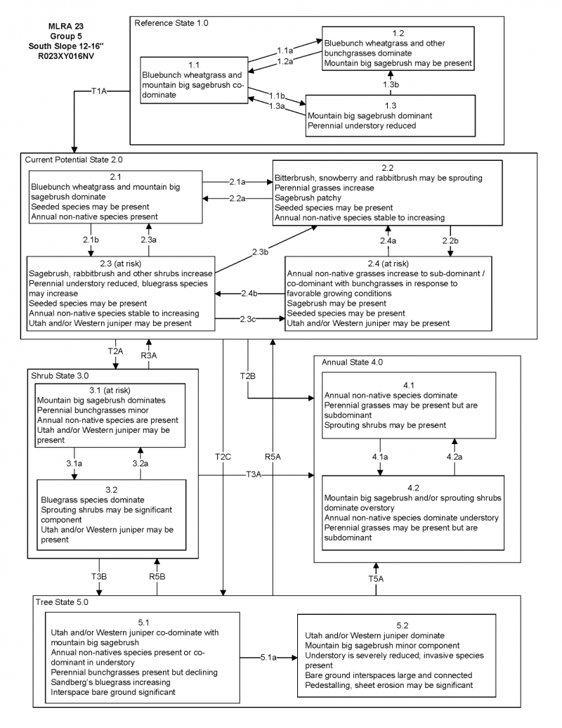
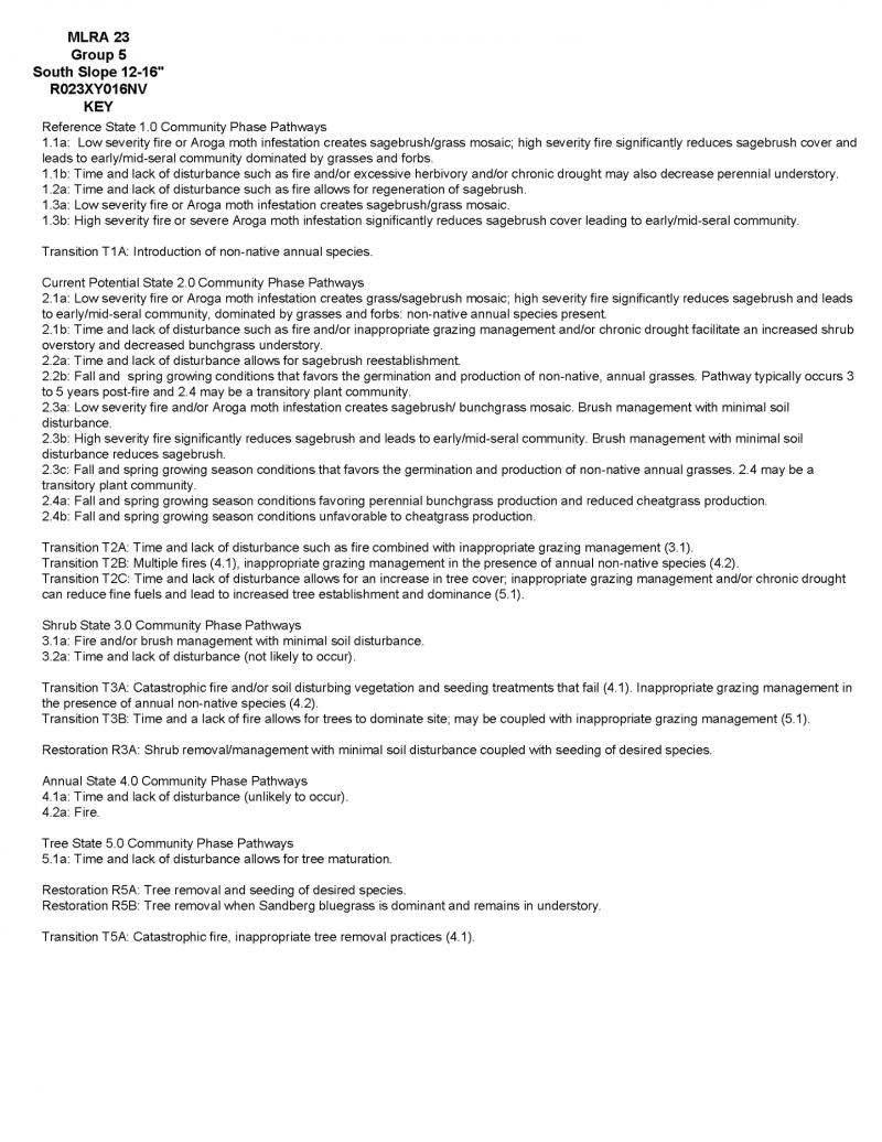
Click on box and path labels to scroll to the respective text.