Natural Resources
Conservation Service
Ecological site R023XY017NV
CLAYPAN 14-16 P.Z.
Last updated: 4/10/2025
Accessed: 04/02/2026
General information
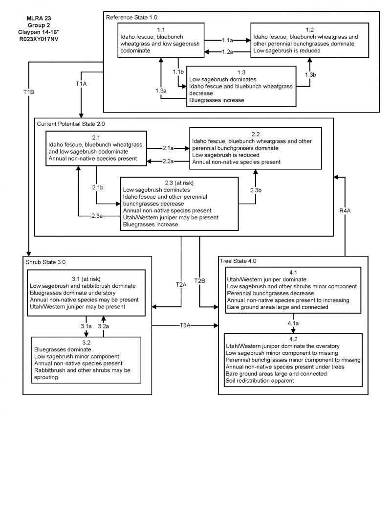
Provisional. A provisional ecological site description has undergone quality control and quality assurance review. It contains a working state and transition model and enough information to identify the ecological site.
Ecological site concept
Currently there is only a draft of the initial concept for this ecological site. The initial concept for this site places it within the Shallow and Mod Deep >12” PZ Low and Lahontan sagebrush and Idaho fescue Ecological Site Group. To view the General STM and other information available for this ESG please go to https://edit.jornada.nmsu.edu/catalogs/esg/023X/R023XY902OR
The Claypan 14-16” (023XY017NV) ecological site is the modal site for this group as it has the most acres mapped. This site occurs on summits and sideslopes of mountains and higher elevation plateaus on all aspects. Slopes range from 2 to 30 percent, but slope gradients of 2 to 8 percent are most typical. Elevations are 6500 to 8000 feet. Average annual precipitation is 14 to over 16 inches. These soils normally have a high percentage of gravels and cobbles on the surface which occupy plant growing space yet help to reduce evaporation and conserve soil moisture. Depth to a fine textured subsoil ranges from 5 to 10 inches. The subsoils swell on wetting, and shrink and crack upon drying. Swelling of the subsoil with wetting in the early spring results in poor soil aeration, forming a perched water table near the surface. Infiltration of water is restricted once these soils are saturated and the site is subject to loss of water by runoff. Loss of the surface layer results in decreased productivity of the plant community. The surface layer has a low available water capacity due to its limited thickness. Because of the higher elevations where this site occurs, the soils are cool and plant growth is not initiated until mid- to late spring. Pedestalling of some grass plants is common during the winter due to frost heaving. The dominant plants on this site are low sagebrush, Idaho fescue, and bluebunch wheatgrass. Thurber’s needlegrass may be a significant component along with several perennial forbs. This site’s annual production is 700 lbs/ac in normal years but can range from 500 to 900 lbs/ac.
Associated sites
| R023XY007NV |
LOAMY 14-16 P.Z. |
|---|---|
| R023XY008NV |
MOUNTAIN RIDGE |
| R023XY016NV |
SOUTH SLOPE 12-16 P.Z. |
| R023XY041NV |
LOAMY 12-14 P.Z. |
Similar sites
| R023XY021NV |
SCABLAND 10-14 P.Z. POSE dominant grass; less productive site |
|---|---|
| R023XY014NV |
SHALLOW LOAM 14+ P.Z. FEID dominant grass |
| R023XY044NV |
VERY COBBLY CLAYPAN POSE dominant grass; less productive site; many cobbles on surface |
| R023XY079NV |
ASHY CLAYPAN (COOL) 10-14 P.Z. FEID dominant grass; high amounts of volcanic ash in soil |
| R023XY031NV |
CLAYPAN 10-14 P.Z. ACTH7-PSSPS codominant |
| R023XY059NV |
GRAVELLY CLAYPAN 10-12 P.Z. ACTH7 dominant grass; less productive site |
| R023XY078NV |
ASHY CLAYPAN 10-14 P.Z. more productive site; high amounts of volcanic ash in soil |
| R023XY008NV |
MOUNTAIN RIDGE FEID dominant grass; less productive site |
| R023XY060NV |
COBBLY CLAYPAN 8-12 P.Z. less productive site; extremely cobbly surface |
Table 1. Dominant plant species
| Tree |
Not specified |
|---|---|
| Shrub |
(1) Artemisia arbuscula |
| Herbaceous |
(1) Festuca idahoensis |

Click on box and path labels to scroll to the respective text.