Natural Resources
Conservation Service
Ecological site R023XY027NV
ASPEN THICKET
Last updated: 4/10/2025
Accessed: 04/02/2026
General information
Provisional. A provisional ecological site description has undergone quality control and quality assurance review. It contains a working state and transition model and enough information to identify the ecological site.
Ecological site concept
Currently there is only a draft of the initial concept for this ecological site. The initial concept for this site places it within the Cold Mountain Slope Quaking Aspen. Ecological Site Group. To view the General STM and other information available for this ESG please go to https://edit.jornada.nmsu.edu/catalogs/esg/023X/F023XY923NV
The Aspen Thicket plant community is dominated by dense stands of low-growing quaking aspen, generally less than 15-feet tall at maturity (locally known as "snowbank" aspen). Visually it is quite different from the modal site in this group, however it will exhibit the same dynamics, just with shorter trees. Each site normally represents a single clone of aspen with a common genetic makeup. Large rock fragments (cobbles and stones) are common throughout the soil profile. Stones may interfere with the lateral spread of shallow roots and can restrict the reproductive ability of aspen. A variety of forbs, mountain brome, needlegrass, slender wheatgrass, and snowberry are important understory species associated with this site and are most prevalent on the periphery of the aspen overstory. This site’s normal understory annual production ranges from 300-800 lb/ac. This site has two stable states.
Associated sites
| F023XY028NV |
Backslope Aspen |
|---|---|
| R023XY007NV |
LOAMY 14-16 P.Z. |
| R023XY019NV |
LOAMY 16+ P.Z. |
| R023XY065NV |
LOAMY SLOPE 16+ P.Z. |
| R023XY066NV |
ASHY LOAM 14-16 P.Z. |
Similar sites
| F023XY028NV |
Backslope Aspen POTR5 in tree form; more productive site |
|---|---|
| F023XY029NV |
POTR5/PONE3-CAREX-ELTR7 POTR5 in tree form; occurs in riparian areas |
Table 1. Dominant plant species
| Tree |
(1) Populus tremuloides |
|---|---|
| Shrub |
Not specified |
| Herbaceous |
(1) Achnatherum |
Physiographic features
This site occurs on concave shoulders of mountains and plateaus on northerly aspects or on the lee-side of snow-blown plateau and mountain summits. Slope gradients are 8 to 70 percent. Elevations are 6000 to 7000 feet.
Table 2. Representative physiographic features
| Landforms |
(1)
Plateau
(2) Mountain slope |
|---|---|
| Elevation | 6,000 – 7,000 ft |
| Slope | 8 – 70% |
| Aspect | Aspect is not a significant factor |
Climatic features
The climate associated with this site is semiarid and characterized by cool, moist winters and warm, dry summers. Average annual precipitation is 14 to over 20 inches. Mean annual air temperature is 40 to 44 degrees F. The average growing season is about 40 to 75 days.
Nevada’s climate is predominantly arid, with large daily ranges of temperature, infrequent severe storms, heavy snowfall in the higher mountains, and great location variations with elevation. Three basic geographical factors largely influence Nevada’s climate: continentality, latitude, and elevation. Continentality is the most important factor. The strong continental effect is expressed in the form of both dryness and large temperature variations. Nevada lies on the eastern, lee side of the Sierra Nevada Range, a massive mountain barrier that markedly influences the climate of the State. The prevailing winds are from the west, and as the warm moist air from the Pacific Ocean ascend the western slopes of the Sierra Range, the air cools, condensation occurs and most of the moisture falls as precipitation. As the air descends the eastern slope, it is warmed by compression, and very little precipitation occurs. The effects of this mountain barrier are felt not only in the West but throughout the state, with the result that the lowlands of Nevada are largely desert or steppes. The temperature regime is also affected by the blocking of the inland-moving maritime air. Nevada sheltered from maritime winds, has a continental climate with well-developed seasons and the terrain responds quickly to changes in solar heating.
Nevada lies within the mid-latitude belt of prevailing westerly winds which occur most of the year. These winds bring frequent changes in weather during the late fall, winter and spring months, when most of the precipitation occurs. To the south of the mid-latitude westerlies, lies a zone of high pressure in subtropical latitudes, with a center over the Pacific Ocean. In the summer, this high-pressure belt shifts northward over the latitudes of Nevada, blocking storms from the ocean. The resulting weather is mostly clear and dry during the summer and early fall, with scattered thundershowers. The eastern portion of the state receives significant summer thunderstorms generated from monsoonal moisture pushed up from the Gulf of California, known as the North American monsoon. The monsoon system peaks in August and by October the monsoon high over the Western U.S. begins to weaken and the precipitation retreats southward towards the tropics (NOAA 2004).
Average annual precipitation is 16 to over 20 inches. Mean annual air temperature is 41 to 44 degrees F. The average growing season is about 50 to 70 days.
Mean annual precipitaion at the Bear Creek, Nevada SNOTEL station (170501020301) is 37.69 inches.
monthly mean precipitation is:
January 3.84; February 3.75; March 4.38; April 4.9;
May 3.99; June 2.82; July .95; August 1.66;
September 1.22; October 2.12;
November 3.67; December 4.38.
Table 3. Representative climatic features
| Frost-free period (average) | 57 days |
|---|---|
| Freeze-free period (average) | |
| Precipitation total (average) | 17 in |
Figure 1. Monthly precipitation range
Figure 2. Monthly average minimum and maximum temperature
Figure 3. Annual precipitation pattern
Figure 4. Annual average temperature pattern
Influencing water features
There are no influencing water features associated with this site.
Soil features
The soils associated with this site are very deep and have a thick, dark-colored, surface layer that is typically medium textured. The soils are well drained, moderately permeable and runoff is high. Large rock fragments (cobbles and stones) are common throughout the soil profile. Stones may interfer with the lateral spread of shallow roots and can restrict the reproductive ability of aspen. Heavy snow accumulation on this site persists late into spring or early summer when the soil is not frozen. Snow, slowly melting during this period, is added to the soil moisture supply and is available to plants during the growing season. The soil series associated with this site include: Hackwood.
Table 4. Representative soil features
| Surface texture |
(1) Very gravelly loam (2) Gravelly sandy loam |
|---|---|
| Family particle size |
(1) Loamy |
| Drainage class | Well drained |
| Permeability class | Moderate |
| Soil depth | 72 – 84 in |
| Surface fragment cover <=3" | 27 – 43% |
| Surface fragment cover >3" | 5% |
| Available water capacity (0-40in) |
4.6 – 4.7 in |
| Calcium carbonate equivalent (0-40in) |
Not specified |
| Electrical conductivity (0-40in) |
Not specified |
| Sodium adsorption ratio (0-40in) |
Not specified |
| Soil reaction (1:1 water) (0-40in) |
6.1 – 7.3 |
| Subsurface fragment volume <=3" (Depth not specified) |
27 – 43% |
| Subsurface fragment volume >3" (Depth not specified) |
5% |
Ecological dynamics
Where management results in abusive livestock use, the aspen overstory can be thinned out and permanent openings in the canopy may be created. If aspen sucker reproduction is inadequate to replace overstory mortality, snowberry, big sagebrush and other shrubs increase and eventually become dominant.
Fire Ecology:
The most important agent of disturbance in aspen forests before 1900 was fire, although other natural disturbances were locally important including windthrow, snow damage, hail, lightning, fungal diseases and insect damage. Most aspen forests in the West are seral and have been dependent upon fire for their perpetuation. If fire occurs at infrequent intervals (e.g. 50-150 years) and is intense enough to kill most of the aspen and competing conifers, then most aspen sites in the West will retain viable stands of aspen. Periodic wildfires prevent over-mature aspen stands and maintain a naturally stratified mosaic of even-aged aspen communities in various stages of successional development. Uneven-aged stands form under stable conditions where the overstory gradually disintegrates with disease or age, and is replaced by aspen suckers. Although aspen forests do not burn readily, aspen trees are extremely sensitive to fire. A severe fire will top-kill the aspen overstory and will stimulate abundant suckering. A severe fire also removes the duff and may kill roots. Repeated fires have a detrimental effect on site quality and can eliminate aspen from a site. Aspen is highly competitive on burned sites and has several adaptations to fire including the following: a) the thin bark has little heat resistance, and aspen is easily top-killed by fire, b) root systems of top-killed stems send up a profusion of sprouts for several years after fire, c)sprouts grow rapidly by extracting water, nutrients, and photosynthate from an extant root system, and may outcompete other woody vegetation, d)following fire, a new, even-aged quaking aspen stand can develop within a decade, and e) aspen is self-thinning and a mature forest of healthy trees can develop from dense sprouts. Fires top-kill mountain snowberry. Although plant survival may be variable, mountain snowberry root crowns usually survive even severe fires. Mountain snowberry sprouts from basal buds at the root crown following fire. Mountain brome is likely to be top-killed by fire, although the coarse stems and broad leaves may be more fire-resistant than fine-leaved bunchgrasses. Mountain brome is most susceptible to fire damage when it is actively growing in spring and early summer. Columbia needlegrass is only slightly to moderately damaged by fire, because it has relatively few culms per clump which may help to minimize the amount of subsurface heat transfer and subsequent damage. Western needlegrass is moderately damaged by fire. The recovery time is between 3 and 5 years. The effects of fire on slender wheatgrass are dependent on its growth form. Tall, decadent plants with many leaves sustain the most fire damage, while those with short, sparse growth form, is the least likely to sustain damage to the root system during a fire.
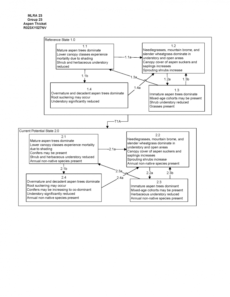
State and transition model

More interactive model formats are also available.
View Interactive Models
Click on state and transition labels to scroll to the respective text
Ecosystem states
State 1 submodel, plant communities
State 1
Reference Plant Community
Community 1.1
Reference Plant Community
The reference plant community is dominated by dense stands of low-growing quaking aspen, genrally less than 15-feet tall at maturity (locally known as "snowbank" aspen). Each site normally represents a single clone of aspen with a common genetic makeup. A variety of forbs, mountain brome, needlegrass, slender wheatgrass, and snowberry are important understory species associated with this site and are most prevalent on the periphery of the aspen overstory. Potential vegetative composition is about 20% grasses, 20% forbs and 60% shrubs and trees. Approximate ground cover (basal and crown) is about 50 to 75 percent.
Figure 5. Annual production by plant type (representative values) or group (midpoint values)
Table 5. Annual production by plant type
| Plant type | Low (lb/acre) |
Representative value (lb/acre) |
High (lb/acre) |
|---|---|---|---|
| Tree | 522 | 754 | 1044 |
| Grass/Grasslike | 180 | 260 | 360 |
| Forb | 180 | 260 | 360 |
| Shrub/Vine | 18 | 26 | 36 |
| Total | 900 | 1300 | 1800 |
Additional community tables
Table 6. Community 1.1 plant community composition
| Group | Common name | Symbol | Scientific name | Annual production (lb/acre) | Foliar cover (%) | |
|---|---|---|---|---|---|---|
|
Grass/Grasslike
|
||||||
| 1 | Primary Perennial Grasses | 156–325 | ||||
| mountain brome | BRMA4 | Bromus marginatus | 65–130 | – | ||
| slender wheatgrass | ELTRT | Elymus trachycaulus ssp. trachycaulus | 26–65 | – | ||
| Columbia needlegrass | ACNEN2 | Achnatherum nelsonii ssp. nelsonii | 33–65 | – | ||
| western needlegrass | ACOCO | Achnatherum occidentale ssp. occidentale | 32–65 | – | ||
| 2 | Secondary Perennial Grasses/Grasslikes | 26–65 | ||||
| sedge | CAREX | Carex | 7–26 | – | ||
| blue wildrye | ELGL | Elymus glaucus | 7–26 | – | ||
| Idaho fescue | FEID | Festuca idahoensis | 7–26 | – | ||
| melicgrass | MELIC | Melica | 7–26 | – | ||
| bluegrass | POA | Poa | 7–26 | – | ||
|
Forb
|
||||||
| 3 | Perennial | 195–390 | ||||
| nettleleaf giant hyssop | AGUR | Agastache urticifolia | 7–65 | – | ||
| fleabane | ERIGE2 | Erigeron | 7–65 | – | ||
| geranium | GERAN | Geranium | 7–65 | – | ||
| waterleaf | HYDRO4 | Hydrophyllum | 7–65 | – | ||
| lupine | LUPIN | Lupinus | 7–65 | – | ||
| ragwort | SENEC | Senecio | 7–65 | – | ||
| meadow-rue | THALI2 | Thalictrum | 7–65 | – | ||
|
Shrub/Vine
|
||||||
| 4 | Primary Shrubs | 26–65 | ||||
| mountain snowberry | SYOR2 | Symphoricarpos oreophilus | 26–65 | – | ||
| 5 | Secondary Shrubs | 26–195 | ||||
| Utah serviceberry | AMUT | Amelanchier utahensis | 13–39 | – | ||
| mountain big sagebrush | ARTRV | Artemisia tridentata ssp. vaseyana | 13–39 | – | ||
| yellow rabbitbrush | CHVI8 | Chrysothamnus viscidiflorus | 13–39 | – | ||
| chokecherry | PRVI | Prunus virginiana | 13–39 | – | ||
| currant | RIBES | Ribes | 13–39 | – | ||
| willow | SALIX | Salix | 13–39 | – | ||
|
Tree
|
||||||
| 6 | Deciduous | 650–895 | ||||
| quaking aspen | POTR5 | Populus tremuloides | 650–895 | – | ||
Interpretations
Animal community
Livestock Interpretations:
This site is suitable for livestock grazing. Grazing management should be keyed to perennial grass production. Mountain brome is one of the most important forage grasses in the quaking aspen zone. Mountain brome is ranked as excellent forage for both cattle and horses and good for domestic sheep. Domestic sheep will graze mountain brome only when it is fairly succulent. Columbia needlegrass provides valuable forage for all classes of livestock. Overall production is generally low in the upper sagebrush and mountain brush zones and at the limits of its range where Columbia needlegrass grows only in scattered patches. It is especially valuable to cattle and horses on summer ranges and to domestic sheep on lambing grounds. It is more often cropped closely by cattle and horses than by sheep. Columbia needlegrass is palatable to livestock throughout its range. As with most needlegrasses, it is most palatable early in the season before the foliage becomes coarse and wiry. Palatability to cows and horses is increased because large amounts of fine leafage remain green throughout the growing season. Palatability of Columbia needlegrass is described as fair to good for cattle and horses, becoming nearly unpalatable at maturity. Western needlegrass has a spreading and deeply penetrating root system, which makes it resistant to trampling. Slender wheatgrass is grazed by all classes of livestock. Snowberry is readily eaten by all classes of livestock, particularly domestic sheep. Most classes of domestic livestock use quaking aspen. Livestock utilization of quaking aspen communities varies with species composition of the understory and relative age of the quaking aspen stand. Young stands generally provide the most browse. Quaking aspen crowns can grow out of reach of large ungulates in 6 to 8 years. Although many animals browse quaking aspen year-round, it is especially valuable during fall and winter, when protein levels are high relative to other browse species. Domestic sheep and cattle browse the leaves and twigs. Domestic sheep browse quaking aspen more heavily than cattle. Heavy livestock browsing can adversely impact quaking aspen growth and regeneration.
Stocking rates vary over time depending upon season of use, climate variations, site, and previous and current management goals. A safe starting stocking rate is an estimated stocking rate that is fine tuned by the client by adaptive management through the year and from year to year.
Wildlife Interpretations:
Quaking aspen is palatable to all browsing wildlife species. Elk browse quaking aspen year-round in much of the West, feeding on bark, branch apices, and sprouts. In some areas, elk use it mainly in winter. Quaking aspen is important forage for mule deer. Deer consume the leaves, buds, twigs, bark, and sprouts. New growth on burns or clearcuts is especially palatable to deer. Deer in many areas use quaking aspen year-round, although in some areas, deer winter below the aspen zone. Quaking aspen provides food for porcupine in winter and spring. Beaver consume the leaves, bark, twigs, and all diameters of quaking aspen branches. They use quaking aspen stems for constructing dams and lodges. Quaking aspen communities provide important feeding and nesting sites for a diverse array of birds. Quaking aspen is host to a variety of insects that are food for woodpeckers and sapsuckers. Many bird species utilize quaking aspen communities of only a particular seral stage. Through most of its range, ruffed grouse depends on quaking aspen for foraging, courting, breeding, and nesting sites. It uses quaking aspen communities of all ages. Favorable ruffed grouse habitat includes quaking aspen stands of at least three different size classes. Young stands provide important brood habitat, and 10- to 25-year-old stands are favored overwintering and breeding areas. Quaking aspen leaves and buds are readily available in abundant quantities in stands greater than 25 years of age, and such older stands are used for foraging. Snowberry is an important forage species for deer and elk on high elevation summer ranges. Snowberry is frequently one of the first species to leaf out, making it a highly sought after food in the early spring. Mountain brome seedheads and seeds provide food for many birds and small mammals. The palatability of mountain brome is excellent for deer, particularly during the late spring and early summer. Columbia needlegrass provides valuable forage for many species of wildlife. It is also consumed by mule deer and other wildlife species throughout the growing season. Needlegrasses are a significant component in the diet of pocket gophers. Columbia needlegrass is palatable to many species of wildlife throughout its range. As with most needlegrasses, it is most palatable early in the season before the foliage becomes coarse and wiry. Palatability of Columbia needlegrass is described as fair for wildlife overall, becoming nearly unpalatable at maturity. Western needlegrass provides valuable forage for many species of wildlife. Slender wheatgrass is grazed by sage grouse, deer, elk, moose, and bighorn sheep, mountain goat, pronghorn, various rodents, and all classes of livestock. The seeds are eaten by various seed predators. Slender wheatgrass provides hiding and thermal cover for songbirds, upland game birds, waterfowl, and small mammals.
Hydrological functions
Runoff is high. Permeability is moderate.
Recreational uses
Aesthetic value is derived from the diverse floral and faunal composition and the colorful flowering of wild flowers and shrubs during the spring and early summer. This site offers rewarding opportunities to photographers and for nature study. This site is used for camping and hiking and has potential for upland and big game hunting.
Other information
Quaking aspens are used to stabilize soil and watersheds. The trees produce abundant litter that contains more nitrogen, phosphorus, potash and calcium than leaf litter of most other hardwoods. The litter decays rapidly, forming nutrient-rich humus that may amount to 25 tons per acre (oven-dry basis). The humus reduces runoff and aids in percolation and recharge of ground water. Mountain snowberry is useful for establishing cover on bare sites and has done well when planted onto roadbanks. Mountain brome is an excellent native bunchgrass for seeding alone or in mixtures in disturbed areas, including depleted rangelands, burned areas, roadways, mined lands, and degraded riparian zones. Slender wheatgrass is widely used for revegetating disturbed lands. Slender wheatgrass is a short-lived perennial with good seedling vigor. It germinates and establishes quickly when seeded making it a good choice for quick cover on disturbed sites. It persists long enough for other, slower developing species to establish. It is especially valuable for use in saline soils. It has been used for rehabilitating mine spoils, livestock ranges, and wildlife habitat and watershed areas.
Supporting information
Type locality
| Location 1: Washoe County, NV | |
|---|---|
| Township/Range/Section | T46N R23E S33 |
| UTM zone | N |
| UTM northing | 301516 |
| UTM easting | 4637367 |
| Latitude | 41° 51′ 48″ |
| Longitude | 119° 23′ 29″ |
| General legal description | SW 1/4 NE 1/4, Catnip Mountain area, Charles Sheldon Antelope Refuge, Washoe County, Nevada. |
Other references
Great Basin Ecological Site Development Project: State and Transition Models for Major Land Resource Area 23, Nevada and portions of California (Online; https://naes.agnt.unr.edu/PMS/Pubs/2019-4060.pdf)
Fire Effects Information System (Online; http://www.fs.fed.us/database/feis/plants/).
USDA-NRCS Plants Database (Online; http://www.plants.usda.gov).
Contributors
BH/SW
T Stringham (UNR under contract with BLM)
Approval
Kendra Moseley, 4/10/2025
Rangeland health reference sheet
Interpreting Indicators of Rangeland Health is a qualitative assessment protocol used to determine ecosystem condition based on benchmark characteristics described in the Reference Sheet. A suite of 17 (or more) indicators are typically considered in an assessment. The ecological site(s) representative of an assessment location must be known prior to applying the protocol and must be verified based on soils and climate. Current plant community cannot be used to identify the ecological site.
| Author(s)/participant(s) | |
|---|---|
| Contact for lead author | |
| Date | 04/11/2025 |
| Approved by | Kendra Moseley |
| Approval date | |
| Composition (Indicators 10 and 12) based on | Annual Production |
Indicators
-
Number and extent of rills:
-
Presence of water flow patterns:
-
Number and height of erosional pedestals or terracettes:
-
Bare ground from Ecological Site Description or other studies (rock, litter, lichen, moss, plant canopy are not bare ground):
-
Number of gullies and erosion associated with gullies:
-
Extent of wind scoured, blowouts and/or depositional areas:
-
Amount of litter movement (describe size and distance expected to travel):
-
Soil surface (top few mm) resistance to erosion (stability values are averages - most sites will show a range of values):
-
Soil surface structure and SOM content (include type of structure and A-horizon color and thickness):
-
Effect of community phase composition (relative proportion of different functional groups) and spatial distribution on infiltration and runoff:
-
Presence and thickness of compaction layer (usually none; describe soil profile features which may be mistaken for compaction on this site):
-
Functional/Structural Groups (list in order of descending dominance by above-ground annual-production or live foliar cover using symbols: >>, >, = to indicate much greater than, greater than, and equal to):
Dominant:
Sub-dominant:
Other:
Additional:
-
Amount of plant mortality and decadence (include which functional groups are expected to show mortality or decadence):
-
Average percent litter cover (%) and depth ( in):
-
Expected annual annual-production (this is TOTAL above-ground annual-production, not just forage annual-production):
-
Potential invasive (including noxious) species (native and non-native). List species which BOTH characterize degraded states and have the potential to become a dominant or co-dominant species on the ecological site if their future establishment and growth is not actively controlled by management interventions. Species that become dominant for only one to several years (e.g., short-term response to drought or wildfire) are not invasive plants. Note that unlike other indicators, we are describing what is NOT expected in the reference state for the ecological site:
-
Perennial plant reproductive capability:
Print Options
Sections
Font
Other
The Ecosystem Dynamics Interpretive Tool is an information system framework developed by the USDA-ARS Jornada Experimental Range, USDA Natural Resources Conservation Service, and New Mexico State University.
Click on box and path labels to scroll to the respective text.