Provisional. A provisional ecological site description has undergone quality control and quality assurance review. It contains a working state and transition model and enough information to identify the ecological site.
MLRA notes
Major Land Resource Area (MLRA): 024X–Humboldt Basin and Range Area
Major Land Resource Area (MLRA): 024X–Humboldt Area
Major land resource area (MLRA) 24, the Humboldt Area, covers an area of approximately 8,115,200 acres (12,680 sq. mi.). It is found in the Great Basin Section of the Basin and Range Province of the Intermontane Plateaus. Elevations range from 3,950 to 5,900 feet (1,205 to 1,800 meters) in most of the area, some mountain peaks are more than 8,850 feet (2,700 meters).
A series of widely spaced north-south trending mountain ranges are separated by broad valleys filled with alluvium washed in from adjacent mountain ranges. Most valleys are drained by tributaries to the Humboldt River. However, playas occur in lower elevation valleys with closed drainage systems. Isolated ranges are dissected, uplifted fault-block mountains. Geology is comprised of Mesozoic and Paleozoic volcanic rock and marine and continental sediments. Occasional young andesite and basalt flows (6 to 17 million years old) occur at the margins of the mountains. Dominant soil orders include Aridisols, Entisols, Inceptisols and Mollisols. Soils of the area are generally characterized by a mesic soil temperature regime, an aridic soil moisture regime and mixed geology. They are generally well drained, loamy and very deep.
Approximately 75 percent of MLRA 24 is federally owned, the remainder is primarily used for farming, ranching and mining. Irrigated land makes up about 3 percent of the area; the majority of irrigation water is from surface water sources, such as the Humboldt River and Rye Patch Reservoir. Annual precipitation ranges from 6 to 12 inches (15 to 30 cm) for most of the area, but can be as much as 40 inches (101 cm) in the mountain ranges. The majority of annual precipitation occurs as snow in the winter. Rainfall occurs as high-intensity, convective thunderstorms in the spring and fall.
Ecological site concept
The soils are very deep and calcareous. Surface soils are less than 10 inches thick and are medium to moderately fine textured. These soils are normally strongly salt and sodium affected in their upper profile with soil reaction and salt and sodium usually decreasing with depth. They are poorly drained and have a seasonally high-water table at depths of 30 to 84 inches. Dominant plants: Greasewood (SAVE4) and Basin wildrye (LECI4).
This ecological site is on floodplains and inset fans, the soil profile is characterized by a fine sand surface texture, an ochric epipedon and include high sodicity, moderately high salinity.
Site are characterized by a very low infiltration, an ochric epipedon, moderate to very strong alkalinity, and SAR greater than 45 in the upper profile.
This ecological site includes sodicity, high amounts of soluble salts in the profile, increased available soil moisture to landscape position and seasonally available ground water.
Soils are characterized by a very low infiltration, an ochric epipedon, moderate to very strong alkalinity, and SAR greater than 45 in the upper profile.
This site is on inset fans and stream terraces. Slopes range from 0 to 2 percent. Elevations range from 4200 to 4800 feet (1280-1463m).
Table 2. Representative physiographic features
Landforms
(1) Stream terrace (2) Inset fan
Runoff class
Low
Flooding duration
Long (7 to 30 days)
Flooding frequency
None to occasional
Ponding frequency
None
Elevation
1,280–1,463 m
Slope
0–2%
Water table depth
76–213 cm
Aspect
Aspect is not a significant factor
Climatic features
The climate on this site is semiarid, characterized by cold, moist winters, and warm, somewhat dry summers. The average annual precipitation is 6 to 10 inches (15-25cm). Mean annual air temperatures is 44 to 52 degrees F. The average growing season is about 90 to 130 days.
Table 3. Representative climatic features
Frost-free period (average)
130 days
Freeze-free period (average)
Precipitation total (average)
254 mm
Bar
Line
Figure 1. Monthly precipitation range
Bar
Line
Figure 2. Monthly average minimum and maximum temperature
Influencing water features
This site is associated with perennial streams, and they are poorly drained and have a seasonally high-water table at depths of 30 to 84 inches (76- 213cm)
Soil features
The soils associated with this site have formed in mixed alluvium of mainly volcanic origin. The soils are very deep and calcareous. Surface soils are less than 10 inches thick and are medium to moderately fine textured. These soils are normally strongly salt and sodium affected in their upper profile with soil reaction and salt and sodium usually decreasing with depth. They are poorly drained and have a seasonally high-water table at depths of 30 to 84 inches. Wetting of these soils dilutes their salt and sodium concentration and the degree of salinity and alkalinity may fluctuate widely through the year. Capillary recharge of salt and sodium from a shallow water table is common. These soils are poorly aerated and have moderately slowly permeability. Seed viability, germination and available water capacity is reduced due to the saline condition of these soils. The surface layer of these soils will crust and bake upon drying, inhibiting water infiltration and seedling emergence. The soil series associated with this site includes: Crutcher.
Table 4. Representative soil features
Parent material
(1) Alluvium–volcanic breccia
Surface texture
(1) Ashy silt loam
Family particle size
(1) Loamy
Drainage class
Poorly drained to somewhat poorly drained
Permeability class
Moderately slow
Soil depth
183–213 cm
Surface fragment cover <=3"
0%
Surface fragment cover >3"
0%
Available water capacity (0-101.6cm)
20.07–20.32 cm
Calcium carbonate equivalent (0-101.6cm)
1–10%
Electrical conductivity (0-101.6cm)
2–32 mmhos/cm
Sodium adsorption ratio (0-101.6cm)
5–45
Soil reaction (1:1 water) (0-101.6cm)
7.9–9
Subsurface fragment volume <=3" (Depth not specified)
0%
Subsurface fragment volume >3" (Depth not specified)
0%
Ecological dynamics
As ecological condition declines, silver buffaloberry, black greasewood, and rubber rabbitbrush increase and become the dominant vegetation in lower condition classes. Inland saltgrass increases as conditions decline and usually dominates the understory. Fivehook bassia and annual mustards are species likely to invade this site.
Fire Ecology:
Black greasewood communities have been historically subject to stand-replacing fire regimes with intervals of less than 100 years. Silver buffaloberry is probably killed by severe fires. Silver buffaloberry has fair tolerance to fire in the dormant state and sprouts from rootstocks following fire. Black greasewood may be killed by severe fires, but it commonly sprouts soon after low to moderate-severity fires. Shadscale is fire intolerant and it does not readily recover from fire, except for establishment through seed. Basin wildrye is top-killed by fire. Older basin wildrye plants with large proportions of dead material within the perennial crown can be expected to show higher mortality due to fire than younger plants having little debris. Basin wildrye is generally tolerant of fire but may be damaged by early season fire combined with dry soil conditions. Alkali sacaton is tolerant of, but not resistant to, fire. Top-killing by fire is probably frequent, and the plants can be killed by severe fire. Saltgrass rhizomes occur deep in the soil where they are insulated from the heat of most fires. Saltgrass survives fire by sending up new growth from rhizomes.
The reference plant community is dominated by silver buffaloberry, black greasewood, and basin wildrye. This site is characterized by medium to dense thickets of silver buffaloberry. Understory vegetation occurs within interspaces of thickets and at dripline along thicket edge. Potential vegetative composition is about 40% grasses, 5% forbs and 55% shrubs. Approximate ground cover (basal and crown) is 20 to 35 percent.
Figure 3. Annual production by plant type (representative values) or group (midpoint values)
Table 5. Annual production by plant type
Plant type
Low (kg/hectare)
Representative value (kg/hectare)
High (kg/hectare)
Shrub/Vine
432
616
863
Grass/Grasslike
314
448
628
Forb
39
56
78
Total
785
1120
1569
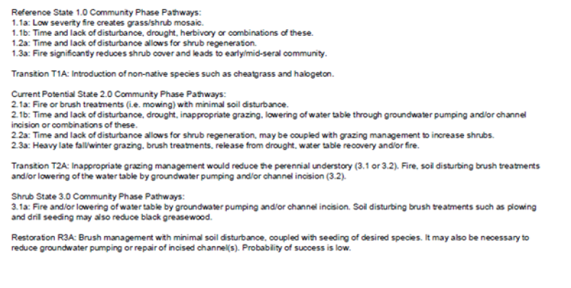
Community 1.2 Reference Plant Community 1.2
This community phase is characteristic of a post-disturbance, early-seral community phase. Basin wildrye and alkali sacaton dominate the community. Black greasewood will decrease but will likely sprout and return to pre-burn levels within a few years. Early colonizers such as rabbitbrush and shadscale may increase.
Community 1.3 Reference Plant Community 1.3
Black greasewood and big sagebrush increase in the absence of disturbance. Decadent shrubs dominate the overstory and deep-rooted perennial bunchgrasses in the understory are reduced either from competition with shrubs, herbivory, drought or combinations of these.
Pathway 1.1a Community 1.1 to 1.2
Fire will decrease or eliminate the overstory of black greasewood and allow the perennial bunchgrasses to dominate the site. Fires will typically be low severity, resulting in a mosaic pattern due to low fuel loads. A fire following an unusually wet spring may be more severe and reduce sagebrush cover to trace amounts.
Pathway 1.1b Community 1.1 to 1.3
Absence of disturbance over time, significant herbivory, long term drought or combinations of these would allow the black greasewood overstory to dominate the site and reduce the perennial bunchgrasses. Inland saltgrass may increase in the understory depending on the timing and intensity of herbivory. Heavy spring utilization will favor an increase in black greasewood.
Pathway 1.2a Community 1.2 to 1.1
Time and lack of disturbance will allow shrubs to increase.
Pathway 1.3a Community 1.3 to 1.2
Fire will decrease the overstory of black greasewood and allow the perennial bunchgrasses to dominate the site. Fires will typically by high intensity in this phase due to the dominance of black greasewood resulting in removal of the overstory shrub community.
State 2 Current Potential State
This state is similar to the Reference State 1.0 with three similar community phases. Ecological function has not changed, however the resiliency of the state has been reduced by the presence of invasive weeds. Non-natives may increase in abundance but will not become dominant within this State. These non-natives can be highly flammable and can promote fire where historically fire had been infrequent. Negative feedbacks enhance ecosystem resilience and contribute to the stability of the state. These feedbacks include the presence of all structural and functional groups, low fine fuel loads, and retention of organic matter and nutrients. Positive feedbacks decrease ecosystem resilience and stability of the state. These include the non-natives’ high seed output, persistent seed bank, rapid growth rate, ability to cross pollinate, and adaptations for seed dispersal.
Community 2.1 Plant community 2.1
This community is dominated by basin wildrye and black greasewood. Alkali sacaton and rabbitbrush are also common on these sites. Inland saltgrass, alkaligrass and other perennial bunchgrasses and shrubs make up smaller components. Non-native annual species such as halogeton and cheatgrass are present.
Community 2.2 Plant community 2.2
This community phase is characteristic of a post-disturbance, early-seral community phase. Basin wildrye and alkali sacaton dominate the community. Black greasewood will decrease but will likely sprout and return to pre-burn levels within a few years. Early colonizers such as rabbitbrush and shadscale may increase. Annual non-native species are stable to increasing in the community.
Community 2.3 Plant community 2.3
Black greasewood and big sagebrush increase in the absence of disturbance. Decadent shrubs dominate the overstory and deep-rooted perennial bunchgrasses in the understory are reduced either from competition with shrubs, inappropriate grazing management, drought or combinations of these.
Pathway 2.1a Community 2.1 to 2.2
A low severity fire would decrease the overstory of black greasewood and allow the understory perennial grasses to increase. Fires are typically low severity resulting in a mosaic pattern due to low fuel loads. A fire following an unusually wet spring facilitating an increase in fine fuels may be more severe and reduce black greasewood cover to trace amounts. Brush treatments would also reduce the shrub overstory and allow the perennial grasses in the understory to increase.
Pathway 2.1b Community 2.1 to 2.3
Absence of disturbance over time, inappropriate grazing management, long term drought, lowering of the water table by groundwater pumping or channel incision or combinations of these would allow the black greasewood overstory to dominate the site and reduce perennial bunchgrasses. Inland saltgrass may increase in the understory depending on the timing and intensity of grazing. Heavy spring utilization will favor an increase in black greasewood.
Pathway 2.2a Community 2.2 to 2.1
Time and lack of disturbance will allow shrubs to increase, this may be coupled with inappropriate grazing management.
Pathway 2.3a Community 2.3 to 2.2
Release from drought and/or water table recovery would allow an increase in perennial bunchgrasses. Fire and/or brush treatments will also decrease the overstory of black greasewood and give a competitive advantage for existing perennial
265
bunchgrasses. This may lead to bunchgrasses dominating the site. Fires will typically by high intensity in this phase due to the dominance of black greasewood resulting in removal of the overstory shrub community.
State 3 Shrub State
This state has two community phases, one that is characterized by a co-dominance of black greasewood and rabbitbrush and the other with rabbitbrush overstory. This site has crossed a biotic threshold and site processes are being controlled by shrubs. Bare ground has increased and pedestalling of grasses may be excessive.
Community 3.1 Plant community 3.1
Decadent black greasewood dominates the site. Perennial bunchgrasses are present but a minor component. Annual non-native species may be present and may be increasing in the understory.
Community 3.2 Plant community 3.2
Rabbitbrush dominates the overstory. Deep-rooted perennial bunchgrasses may be present in trace amounts or absent from the community. Annual non-native species increase. Bare ground is significant.
Pathway 3.1a Community 3.1 to 3.2
Soil disturbing treatments such as plowing and drill seeding would decrease black greasewood and allow rabbitbrush to dominate site. Lowering of the water table through groundwater pumping and/or channel incision would also decrease black greasewood.
Transition T1A State 1 to 2
Introduction of non-native species such as cheatgrass and halogeton.
Transition T2A State 2 to 3
Inappropriate grazing management would reduce the perennial understory (3.1 or 3.2). Fire, soil disturbing brush treatments and/or lowering of the water table by groundwater pumping and/or channel incision (3.2).
Restoration pathway R3A State 3 to 2
Brush management with minimal soil disturbance, coupled with seeding of desired species. It may also be necessary to reduce groundwater pumping or repair of incised channel(s). Probability of success is low.
Additional community tables
Table 6. Community 1.1 plant community composition
Livestock Interpretations:
This site is suitable for livestock grazing. Grazing management should be keyed to dominant grasses and palatable shrubs production. Silver buffaloberry is nearly worthless as livestock forage due to its thornlike twigs. Silver buffaloberry is fair forage for sheep. Forage production under dense, thorny, monotypic stands of silver buffaloberry is low; as stands open up, forage production increases. Black greasewood is an important winter browse plant for domestic sheep and cattle. It also receives light to moderate use by domestic sheep and cattle during spring and summer months. Black greasewood contains soluble sodium and potassium oxalates that may cause poisoning and death in domestic sheep and cattle if large amounts are consumed in a short time. Shadscale is a valuable browse species, providing a source of palatable, nutritious forage for a wide variety of livestock. Shadscale provides good browse for domestic sheep. Shadscale leaves and seeds are an important component of domestic sheep and cattle winter diets. The early growth and abundant production of basin wildrye make it a valuable source of forage for livestock. It is important forage for cattle and is readily grazed by cattle and horses in early spring and fall. Though coarse-textured during the winter, basin wildrye may be utilized more frequently by livestock and wildlife when snow has covered low shrubs and other grasses. Alkali sacaton is a valuable forage species in arid and semiarid regions. Plants are tolerant to moderate grazing and can produce abundant herbage utilized by livestock. Saltgrass's value as forage depends primarily on the relative availability of other grasses of higher nutritional value and palatability. It can be an especially important late summer grass in arid environments after other forage grasses have deceased. Saltgrass is rated as a fair to good forage species only because it stays green after most other grasses dry. Livestock generally avoid saltgrass due to its coarse foliage. Saltgrass is an increaser under grazing pressure.
Stocking rates vary over time depending upon season of use, climate variations, site, and previous and current management goals. A safe starting stocking rate is an estimated stocking rate that is fine tuned by the client by adaptive management through the year and from year to year.
Wildlife Interpretations:
Silver buffaloberry is utilized by mule deer and pronghorn in the winter. Black greasewood is an important winter browse plant for big game animals and a food source for many other wildlife species. It also receives light to moderate use by mule deer and pronghorn during spring and summer months. Shadscale is a valuable browse species, providing a source of palatable, nutritious forage for a wide variety of wildlife particularly during spring and summer before the hardening of spiny twigs. It supplies browse, seed, and cover for birds, small mammals, rabbits, deer, and pronghorn antelope. Basin wildrye provides winter forage for mule deer, though use is often low compared to other native grasses. Basin wildrye provides summer forage for black-tailed jackrabbits. Because basin wildrye remains green throughout early summer, it remains available for small mammal forage for a longer time than other grasses. The western salt desert shrub and grassland communities where alkali sacaton is common support an abundance of mule deer, pronghorn, carnivores, small mammals, birds, amphibians, and reptiles. Saltgrass provides cover for a variety of bird species, small mammals, and arthropods and is on occasion used as forage for several big game wildlife species.
Hydrological functions
Runoff is high and ponding occurs in some areas. Potential for sheet and rill erosion is slight. Permeability is moderately slow. Hydrologic soil group is C. Rills are none. Water flow patterns are rare to common depending on site location relative to major inflow areas. Moderately fine to fine surface textures and physical crusts result in limited infiltration rates. The surface layer will normally crust and bake upon drying, inhibiting water infiltration and seedling emergence. Pedestals are none. There are typically no gullies associated with this site. Shrubs and deep-rooted perennial herbaceous bunchgrasses and/or rhizomatous grasses aid in infiltration. Shrub canopy and associated litter break raindrop impact.
Recreational uses
Aesthetic value is derived from the diverse floral and faunal composition and the colorful flowering of wild flowers and shrubs during the spring and early summer. This site offers rewarding opportunities to photographers and for nature study. This site is used for hiking and has potential for upland and big game hunting.
Other products
Pioneers preserved the fruit of silver buffaloberry and made a sauce from the berries. Today the fruit is used to make pies, jams, and jellies. Silver buffaloberry is planted as an ornamental. The leaves, seeds and stems of black greasewood are edible. Seeds of shadscale were used by Native Americans for bread and mush. Basin wildrye was used as bedding for various Native American ceremonies, providing a cool place for dancers to stand.
Other information
Silver buffaloberry adapts well to disturbed or degraded sites in the Intermountain region. It is used for multiple-row windbreaks, shelterbelts, erosion control, wildlife habitat enhancement, and land reclamation. Nursery-grown stock readily establishes on disturbed sites and once established, silver buffaloberry is a good soil stabilizer. Silver buffaloberry is used for erosion control in riparian areas in the Intermountain region. Black greasewood is useful for stabilizing soil on wind-blown areas. It successfully revegetates eroded areas and sites too saline for most plant species. Basin wildrye is useful in mine reclamation, fire rehabilitation and stabilizing disturbed areas. Its usefulness in range seeding, however, may be limited by initially weak stand establishment. Alkali sacaton is one of the most commonly used species for seeding and stabilizing disturbed lands. Due to alkali sacaton’s salt tolerance, is recommended for native grass seeding on subirrigated saline sites. Given its extensive system of rhizomes and roots which form a dense sod, saltgrass is considered a suitable species for controlling wind and water erosion.
Supporting information
Inventory data references
NASIS soil component data.
Type locality
Location 1: Humboldt County, NV
Township/Range/Section
T44 N R36 E S12
UTM zone
N
UTM northing
4617664
UTM easting
427212
Latitude
41° 42′ 26″
Longitude
117° 52′ 29″
General legal description
Quinn River floodplain about 3 miles north of Ellison Ranch, Humboldt County, Nevada.
Interpreting Indicators of Rangeland Health is a qualitative assessment protocol used to
determine ecosystem condition based on benchmark characteristics described in the Reference Sheet. A suite of 17 (or
more) indicators are typically considered in an assessment. The ecological site(s) representative of an assessment
location must be known prior to applying the protocol and must be verified based on soils and climate. Current plant
community cannot be used to identify the ecological site.
Author(s)/participant(s)
Patti Novak-Echenique
Contact for lead author
State Rangeland Management Specialist
Date
03/19/2010
Approved by
Kendra Moseley
Approval date
Composition (Indicators 10 and 12) based on
Annual Production
Indicators
Number and extent of rills:
Rills are none.
Presence of water flow patterns:
Water flow patterns are rare to common depending on site location relative to major inflow areas. Moderately fine to fine surface textures and physical crusts result in limited infiltration rates. The surface layer will normally crust and bake upon drying, inhibiting water infiltration and seedling emergence.
Number and height of erosional pedestals or terracettes:
Pedestals are none.
Bare ground from Ecological Site Description or other studies (rock, litter, lichen, moss, plant canopy are
not bare ground):
Bare Ground 30-50%.
Number of gullies and erosion associated with gullies:
There are typically no gullies associated with this site.
Extent of wind scoured, blowouts and/or depositional areas:
None
Amount of litter movement (describe size and distance expected to travel):
Fine litter (foliage of grasses and annual & perennial forbs) expected to move distance of slope length during periods of intense summer convection storms or run in of early spring snow melt flows. Persistent litter (large woody material) will remain in place except during unusual flooding (ponding) events.
Soil surface (top few mm) resistance to erosion (stability values are averages - most sites will show a range
of values):
Soil stability values will range from 1 to 4. (To be field tested.)
Soil surface structure and SOM content (include type of structure and A-horizon color and thickness):
Structure of soil surface is subangular blocky. Soil surface colors are dark and soils are typified by a mollic epipedon. Organic matter of the surface 2 to 3 inches is typically 3 to 5 percent.
Effect of community phase composition (relative proportion of different functional groups) and spatial
distribution on infiltration and runoff:
Shrubs and deep-rooted perennial herbaceous bunchgrasses and/or rhizomatous grasses aid in infiltration. Shrub canopy and associated litter break raindrop impact.
Presence and thickness of compaction layer (usually none; describe soil profile features which may be
mistaken for compaction on this site):
Compacted layers are not typical. Subangular blocky, prismatic, or massive subsurface layers are normal for this site and are not to be interpreted as compaction.
Functional/Structural Groups (list in order of descending dominance by above-ground annual-production or live foliar
cover using symbols: >>, >, = to indicate much greater than, greater than, and equal to):
Amount of plant mortality and decadence (include which functional groups are expected to show mortality or
decadence):
Dead branches within individual shrubs common and standing dead shrub canopy material may be as much as 25% of total woody canopy.
Average percent litter cover (%) and depth ( in):
Between plant interspaces (25-30%) and depth (± ½ in.)
Expected annual annual-production (this is TOTAL above-ground annual-production, not just forage annual-production):
For normal or average growing season (March thru May) ± 1000 lbs/ac.
Potential invasive (including noxious) species (native and non-native). List species which BOTH characterize
degraded states and have the potential to become a dominant or co-dominant species on the ecological site if
their future establishment and growth is not actively controlled by management interventions. Species that become
dominant for only one to several years (e.g., short-term response to drought or wildfire) are not invasive
plants. Note that unlike other indicators, we are describing what is NOT expected in the reference state for the
ecological site:
Increasers include rubber rabbitbrush. Invaders include annual mustards, five-hook bassia, Russian thistle, halogeton, salt cedar, and cheatgrass.
Perennial plant reproductive capability:
All functional groups should reproduce in average (or normal) and above average growing season years.
The Ecosystem Dynamics Interpretive Tool is an information system framework developed by the USDA-ARS Jornada Experimental Range, USDA Natural Resources Conservation Service, and New Mexico State University.
Click on box and path labels to scroll to the respective text.