Ecological dynamics
Plant tables have not been developed for this site. Until such time as they can be updated, use the plant tables in the referenced literature that correlates to this concept (refer to correlations to legacy ecological sites section below). With respect to the imperfect alignment of such correlations, be aware of these shortcomings in their applicability to conservation planning.
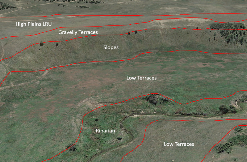
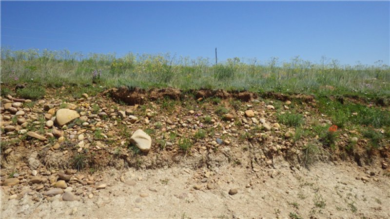
The Gravelly Terraces ecological site is usually dominated by short grasses, but also contains a mix of shrubs, forbs, and often trees. As is typical of plant communities, pronounced annual variations in precipitation translate to considerable short-term fluctuations in annual production within a given plant community phase.
There are numerous variables which affect the range of characteristics for this ecological site. Variables such as elevation, latitude, and orographic effects create a climatic gradient which influence the distribution of C3 and C4 plants. Soil properties such as surface texture, depth to clay layer, parent material, and accumulated salts affect species diversity and composition. Natural disturbances such as drought and wildfire affect species density and cover. The climate gradient across the CP LRU shows a greater distribution of C3 plants such as western wheatgrass and bottlebrush squirreltail where temperatures are cooler, and moisture is more abundant.
Fire is a disturbance regime that reduces succulents and shrubs while stimulating grasses and forbs. Not all fires are equal. According to Gebow (2001), fire effects in the same location will vary, especially with fire timing, both seasonally and within the scheme of year-to-year moisture variation. Precipitation during seasons before and after fire has a major effect on recovery of plants. Fire promotes rhizomatous plant species, such as western wheatgrass, that can take advantage of below-ground rhizomes from which tillering is rapidly initiated.
Grazing pressure will tend to favor grasses such as blue grama and purple threeawn as well as shrubs such as broom snakeweed and fringed sagebrush.
Correlation to Current Ecological Sites:
The Gravelly Terraces is currently correlated to the MLRA 70A Gravelly Upland ecological site (R070AY016NM) in San Miguel and Mora Counties, and to the MLRA 77B Gravelly ecological site (R077BY009NM) in Colfax County. Of the two, R077BY009NM seems to be the most applicable—even though it was apparently developed in another MLRA. Oddly, R070AY016NM appears to have been developed based on plant community data from warmer (thermic) areas. For example, the reference state for R070AY016NM lists sand bluestem as a dominant plant. While neither legacy ESD is perfectly applicable to the current site, these two legacy documents include useful information.
Gravelly Upland (R070AY016NM) tables
Annual production by plant type
Plant Type-----------Low(Lb/Acre)-------Representative Value(Lb/Acre) -------High(Lb/Acre)
Grass/Grasslike----------456----------------------------700--------------------------------------988
Shrub/Vine----------------48-----------------------------150---------------------------------------208
Forb-------------------------48------------------------------87----------------------------------------104
Total-------------------------552----------------------------937--------------------------------------1300
Community 1.1 plant community composition
Common Name-------Symbol-------Scientific Name-------Annual Production (Lb/Acre)
GRASS/GRASSLIKE
1 blue grama------------BOGR2-------Bouteloua gracilis------------55–105
vine mesquite-----------PAOB---------Panicum obtusum------------30–77
plains muhly------------MUCU3-------Muhlenbergia cuspidata----18–65
ring muhly---------------MUTO2-------Muhlenbergia torreyi--------18–65
spike muhly-------------MUWR--------Muhlenbergia wrightii-------18–65
buffalograss-------------BODA2--------Bouteloua dactyloides-------18–65
2-------Tall Warm Season-------90–260
alkali sacaton------------SPAI------------Sporobolus airoides----------55–105
3-------Tall Cool Season Stolon-------200–600
western wheatgrass----PASM---------Pascopyrum smithii-----------115–154
4-------Mid warm season stolon-------30–130
galleta grass--------------PLEUR12-----Pleuraphis------------------------30–77
5-------Tall warm season-------30–130
sideoats grama-----------BOCU---------Bouteloua curtipendula------30–130
6-------Short Coarse warm season-------10–2
threeawn-------------------ARIST---------Aristida---------------------------18–35
eastern bottlebrush grass-ELHYH-----Elymus hystrix var. hystrix---10–23
SHRUB/VINE
7-------Mid palatable drought tolerant-------30–130
fourwing saltbush-------ATCA2-------Atriplex canescens----------------30–77
8-------short high protein-------18–35
winterfat-------------------KRLA2-------Krascheninnikovia lanata-------18–35
9-------Low durable deciduous-------18–35
Gambel oak----------------QUGA-------Quercus gambelii-----------------18–35
11-------Cactus 12–52
tree cholla------------------CYIM2------Cylindropuntia imbricata--------6–32
cactus apple----------------OPEN3------Opuntia engelmannii------------6–32
13-------Wolf Berry-------6–26
Berlandier's wolfberry----LYBE--------Lycium berlandieri---------------6–26
14-------Yucca-------6–26
soapweed yucca-----------YUGL-------Yucca glauca------------------------3–26
15-------Sagewort-------3–26
field sagewort--------------ARCA12-----Artemisia campestris------------3–26
FORB
10-------perennial forbs 6–13
hairy ragweed--------------AMCA7------Ambrosia canescens-----------10–30
globemallow----------------SPHAE-------Sphaeralcea----------------------10–30
buckwheat-------------------ERIOG-------Eriogonum------------------------3–26
Wright's spiderwort-------TRWR-------Tradescantia wrightii-----------6–13
TREE
12------- Juniper 6–32
Rocky Mountain juniper--JUSC2-------Juniperus scopulorum----------6–32
---------------------------------------------------------------------------------------------------------------------
Gravelly (R077BY009NM) tables
Annual production by plant type
Plant Type-----------Low(Lb/Acre) --------Representative Value(Lb/Acre) --------High(Lb/Acre)
Grass/Grasslike--------183------------------------383----------------------------------------584
Shrub/Vine----------------33------------------------68----------------------------------------104
Forb------------------------33------------------------68----------------------------------------104
Total------------------------249------------------------519----------------------------------------792
Community 1.1 plant community composition
Common Name--------Symbol--------Scientific Name--------Annual Production (Lb/Acre)
GRASS/GRASSLIKE
1--------Hairy Grama, Blue Grama, Ltle Blstm, Sideoats Gram--------79–105
sideoats grama----------BOCU--------Bouteloua curtipendula----------79–105
blue grama---------------BOGR2-------Bouteloua gracilis-----------------79–105
copper fern---------------BOHI---------Bommeria hispida-----------------79–105
little bluestem------------SCSC---------Schizachyrium scoparium-------79–105
2--------Wolftail--------16–26
common wolfstail--------LYPH--------Lycurus phleoides------------------16–26
3--------New Mexico Feathergrass, Needleandthread--------------------53–79
needle and thread-------HECO2-----Hesperostipa comata---------------53–79
New Mexico feathergrass-HENE5--Hesperostipa neomexicana-------53–79
4--------Threeawn spp. --------16–26
threeawn-------------------ARIST-------Aristida--------------------------------16–26
5--------Other Grasses--------16–26
Graminoid (grass or grass-like)-2GRAM-Graminoid (grass or grass-like)-16–26
FORB
6--------Prairie Coneflwr, Buckwht sp., Per Forbs, An For--------16–26
Forb, annual----------------2FA----------Forb, annual------------------------16–26
Forb, perennial-------------2FP----------Forb, perennial---------------------16–26
buckwheat-------------------ERIOG------Eriogonum---------------------------16–26
upright prairie coneflower-RACO3----Ratibida columnifera-----------16–26
SHRUB/VINE
7--------Yucca spp. --------16–26
yucca--------------------------YUCCA------Yucca--------------------------------16–26
8--------Gambel Oak--------16–26
Gambel oak------------------QUGA-------Quercus gambelii----------------16–26
9--------Bigelow Sagebrush, Fringed Sagewort, Other Shrubs----------16–26
Shrub, deciduous------------2SD----------Shrub, deciduous---------------16–26
Bigelow sage-----------------ARBI3--------Artemisia bigelovii--------------16–26
prairie sagewort-------------ARFR4-------Artemisia frigida-----------------16–26
--------------------------------------------------------------------------------------------------------------
The following are excerpts from soil survey manuscripts:
From San Miguel County (NM630): Tinaja gravelly loam, hilly map unit
The potential plant community on this unit is mainly sideoats grama, blue grama, little bluestem, and New Mexico feathergrass. As the range deteriorates, the proportion of the desirable forage plants decreases and the proportion of threeawn, wolftail, blue grama, and Gambel oak increases. Oneseed juniper invades. Grazing management should be designed to increase the productivity and reproduction of sideoats grama, little bluestem, and New Mexico feathergrass.
From the Mora (NM638) and San Miguel manuscript descriptions for Tinaja gravelly loam, moderately steep:
The potential natural plant community on this unit is mainly sideoats grama, blue grama, little bluestem, hairy grama, and New Mexico feathergrass. As the potential natural plant community deteriorates, sideoats grama, little bluestem, and New Mexico feathergrass decrease and the blue grama forms a dense, low turf. Plants that occur in the potential natural plant community in smaller amounts such as ring muhly, wolfstail, threeawn, broom snakeweed, fringed sagebrush, and oneseed juniper increase. Grazing management should be designed to increase the vigor, productivity, and reproduction of sideoats grama, New Mexico feathergrass, and little bluestem.
The average annual production of air-dry vegetation on this unit ranges from 1,150 pounds per acre in favorable years to 450 pounds in unfavorable years
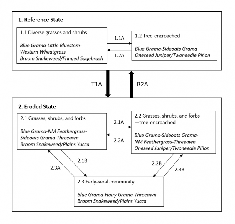
State 1
Reference State
This state occurs where topsoil has remained relatively stable for a very long period. These stable soils exhibit thick dark surface horizons (meeting mollic criteria) that lack free carbonates (no reaction to HCl). Conversely, State 2 is characterized by a truncated soil with free carbonates at the surface (frothy reaction to HCl). Where the Gravelly Terraces ecological site occurs on the shoulders of actively eroding escarpments, there is generally a strip of highly eroded Tinaja soil somewhere on the escarpment. In this scenario, it is not uncommon for States 1 and 2 to occur on the same slope—with State 2 subtending State 1.
The presence of intact topsoil is ecologically important here for several reasons. First, it is usually lower in clay and higher in organic matter than the subsoil. This translates to higher potential plant available water in the rooting zone of many plants—particularly of herbaceous species. Second, the argillic (higher clay) horizon below the topsoil serves as a temporary aquitard which perches water in the topsoil during/after precipitation events. Third, the original topsoil has been leached of carbonates—giving it a relatively neutral pH. This, coupled with higher organic matter translates to higher availability of many essential plant nutrients. Lastly, this topsoil serves as a seedbank.
Community 1.1
1.1 Diverse grasses and shrubs
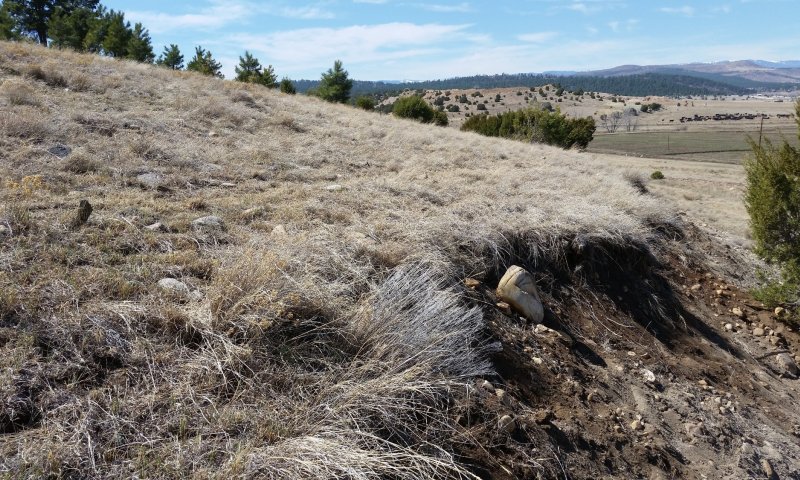
Figure 6. Community 1.1 on the riser of a strath terrace in San Miguel County, March 2017. State 1 occurs on the vegetated terrain above the cut. Note the thick topsoil exposed in the cut, and the grass-dominated plant community above.
This community is dominated by grasses, but also contains shrubs, and forbs, and the occasional tree. Foliar cover is approximately 80 percent, and bare ground is typically less than 5 percent—due largely to a preponderance of surface fragments. Total canopy cover of grasses ranges from 35 to 60 percent. Shrub cover ranges from 5 to 10 percent. Annual production averages around 1,500 pounds per acre, but varies considerably in response to annual weather patterns.
This community generally occurs where season-long grazing has not been practiced in a number of years. Blue grama is the dominant grass. Palatable species such as little bluestem and western wheatgrass are well-represented. The shrub community is usually dominated by broom snakeweed and/or fringed sagebrush. Oneseed juniper and twoneedle pinyon are the tree species that can inhabit this phase, albeit in small numbers.
It should be noted that all of the plant communities observed on the Gravelly Terraces ecological site showed evidence of a history of continuous grazing, and Community Phase 1.1 probably does not reflect pre-Columbian conditions.
Community 1.2
Tree-encroached
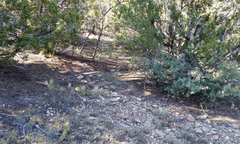
Figure 7. Community 1.2 in Mora County, October 2017.
In this community, trees have gained a competitive advantage, and may even dominate the plant community. Foliar cover is approximately 60 percent, and bare ground is typically less than 5 percent—due largely to a preponderance of tree litter and surface fragments. Total canopy cover of trees ranges from 5 to 40 percent. Total canopy cover of grasses ranges from 10 to 40 percent. Shrub cover is typically around 5 percent. Annual production averages around 1,000 pounds per acre, but varies considerably in response to annual weather patterns and the degree of tree dominance.
This community occurs where fire has been absent for a number of years. Oneseed juniper and twoneedle pinyon are the most common tree species. Blue grama typically dominates the grass community, but sideoats grama, silvery bluestem, and wolfstail are also common. The shrub community is often diverse, and includes Plains pricklypear, Gambel oak, fringed sagebrush, and skunkbush sumac.
Pathway 1.1A
Community 1.1 to 1.2
1.1 Diverse grasses and shrubs
This pathway represents the encroachment of tree species. The most likely mechanisms are season-long grazing providing little rest and recovery for preferred grazed plants during critical growing periods, coupled with high utilization, along with fire suppression.
Pathway 1.2A
Community 1.2 to 1.1
1.1 Diverse grasses and shrubs
This pathway represents tree mortality caused by fire, mechanical treatment, or perhaps herbicide application.
State 2
Eroded State
This state occurs where topsoil has been removed—generally by water erosion. Here, a subsoil that is higher in clay and lower in organic matter now resides at or near the soil surface. This translates to reduced infiltration rates and to lower potential plant available water than in State 1. In most cases, the subsoil contains significant amounts of free carbonates—both as masses in the soil matrix and coatings on rock fragments. When exposed at the soil surface, this calcareous material selects for certain plant species that are generally absent in State 1. Most notably, New Mexico feathergrass is quite prominent in two of the three phases of State 2.
Community 2.1
Grasses, shrubs, and forbs
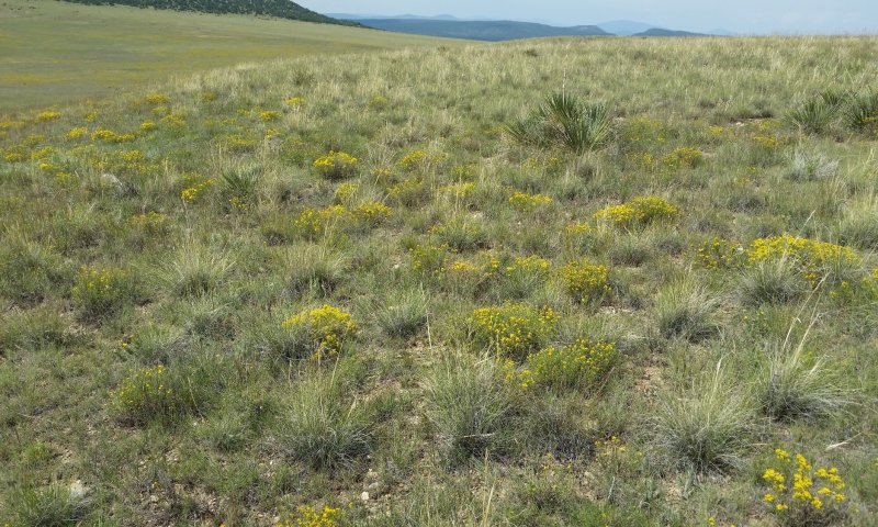
Figure 8. Community 2.1 in Mora County, September 2017. The prominent bunchgrass is New Mexico feathergrass, and the flowering sub-shrub is broom snakeweed. The fragments exposed at the surface here are coated with carbonates.
This community is dominated by grasses, but also contains shrubs, and forbs, and the occasional tree. Foliar cover is approximately 70 percent, and bare ground is typically less than 15 percent—due largely to a preponderance of surface fragments. Total canopy cover of grasses ranges from 35 to 60 percent. Shrub cover ranges from 10 to 30 percent. Annual production averages around 1,300 pounds per acre, but varies considerably in response to annual weather patterns.
Blue grama, New Mexico feathergrass, and sideoats grama are the dominant grasses. Purple threeawn and wolfstail are typically well-represented. Western wheatgrass is generally absent. The shrub community is usually dominated by broom snakeweed and/or fringed sagebrush. Oneseed juniper and twoneedle pinyon are the tree species that can inhabit this phase, albeit in small numbers.
Community 2.2
Grasses, shrubs, and forbs—tree-encroached
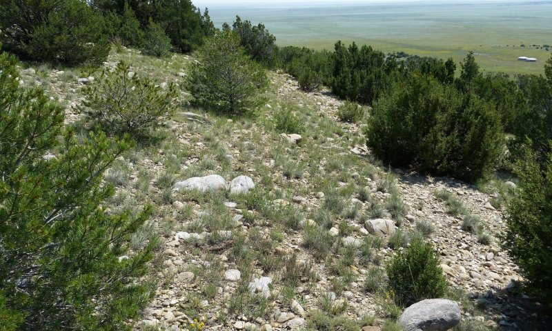
Figure 9. Community 2.2 in Mora County, September 2017. Twoneedle piñon and oneseed juniper are codominant here. Blue grama, New Mexico feathergrass, and sideoats grama are the dominant grasses.
This community occurs on eroded sites where tree encroachment has not been countered by phenomena such as fire and chemical/mechanical treatments. Grasses are either dominant or codominant to trees. Foliar cover is approximately 70 percent, and bare ground is typically less than 15 percent—due largely to a preponderance of surface fragments. Total canopy cover of grasses ranges from 30 to 50 percent. Shrub cover ranges from 10 to 30 percent. Annual production averages around 1,000 pounds per acre, but varies considerably in response to annual weather patterns.
Blue grama, New Mexico feathergrass, and sideoats grama are the dominant grasses. Early-seral grasses such as purple threeawn, sleepygrass, and silvery bluestem are typically well-represented. Western wheatgrass is generally absent. Oneseed juniper and twoneedle pinyon are the most common tree species. The shrub community is usually dominated by broom snakeweed and/or fringed sagebrush
Community 2.3
Early-seral community
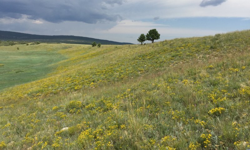
Figure 10. Community 2.3 in Mora County, August 2017. Note the preponderance of broom snakeweed here.
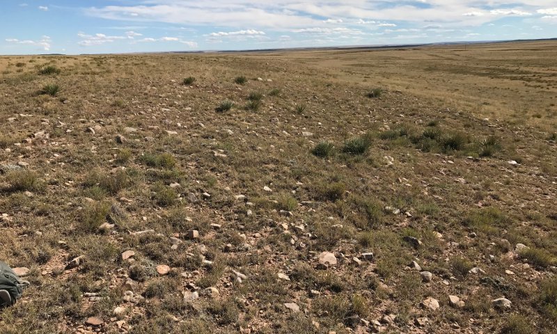
Figure 11. Community 2.3 in Mora County, October 2018.
This community is dominated by grasses, but shrubs may achieve codominance in some cases. Foliar cover is approximately 65 percent, and bare ground is typically less than 15 percent—due largely to a preponderance of surface fragments. Total canopy cover of grasses ranges from 30 to 60 percent. Shrub cover ranges from 10 to 35 percent. Annual production averages around 1,100 pounds per acre, but varies considerably in response to annual weather patterns.
Blue grama and sideoats grama are the dominant grasses. Early-seral grasses such as purple threeawn, sleepygrass, and silvery bluestem are typically well-represented. Western wheatgrass is generally absent. The shrub community is usually dominated by broom snakeweed and/or fringed sagebrush. Oneseed juniper and twoneedle pinyon are the tree species that can inhabit this phase, albeit in small numbers.
Pathway 2.1A
Community 2.1 to 2.2
Grasses, shrubs, and forbs
Grasses, shrubs, and forbs—tree-encroached
This pathway represents the encroachment of tree species. The most likely mechanisms are season-long grazing providing little rest and recovery for preferred grazed plants during critical growing periods, coupled with high utilization, along with fire suppression.
Pathway 2.1B
Community 2.1 to 2.3
Grasses, shrubs, and forbs
This pathway represents the drastic reduction or extirpation of New Mexico feathergrass. This could be expected where heavy, continuous grazing occurs in the late spring—during seed-set of New Mexico feathergrass.
Pathway 2.2A
Community 2.2 to 2.1
Grasses, shrubs, and forbs—tree-encroached
Grasses, shrubs, and forbs
This pathway represents a drastic reduction in tree cover. Fire, herbicide application, and mechanical treatments are thought to be the most common mechanisms.
Pathway 2.2B
Community 2.2 to 2.3
Grasses, shrubs, and forbs—tree-encroached
This pathway represents the drastic reduction or extirpation of New Mexico feathergrass, coupled with the reduction or elimination of tree species. This could be expected where heavy, continuous grazing occurs in the late spring—coupled with tree-killing processes such as those outlined in 2.2A.
Pathway 2.3A
Community 2.3 to 2.1
Grasses, shrubs, and forbs
This pathway represents the re-emergence of New Mexico feathergrass as a dominant species. This seems most likely where grazing is curtailed during the late spring.
Pathway 2.3B
Community 2.3 to 2.2
Grasses, shrubs, and forbs—tree-encroached
This pathway represents the encroachment of tree species. The most likely mechanisms are season-long grazing providing little rest and recovery for preferred grazed plants during critical growing periods, coupled with high utilization, along with fire suppression.
Transition T1A
State 1 to 2
Significant water erosion removes much of the original topsoil, exposing subsurface horizons that contain free carbonates. Mechanisms for this event are varied. Active erosion of shale-derived soils on escarpment positions can lead to head-cutting into the Gravelly Terraces site. Excessive grazing on the Gravelly Terraces can also lead to erosion here. It is also possible that a high intensity fire could create a hydrophobic soil surface, which would promote runoff and attendant erosion.
Restoration pathway R2A
State 2 to 1
This pathway represents the genesis of a layer of thick, organic-rich topsoil. Theoretically, this pathway would proceed most rapidly from Community Phase 2.1—where relatively high herbaceous production would favor the accumulation of soil organic matter. Barring expensive and high-energy inputs such as trucking-in topsoil, this restoration pathway will be quite slow. It would involve the accumulation of large amounts of soil organic matter, the leaching and neutralization of carbonates from the upper soil, and the illuviation of significant amounts of clay from the upper soil. These pedogenic processes cannot be expected to produce State 1 conditions on the scale of a human lifespan.


