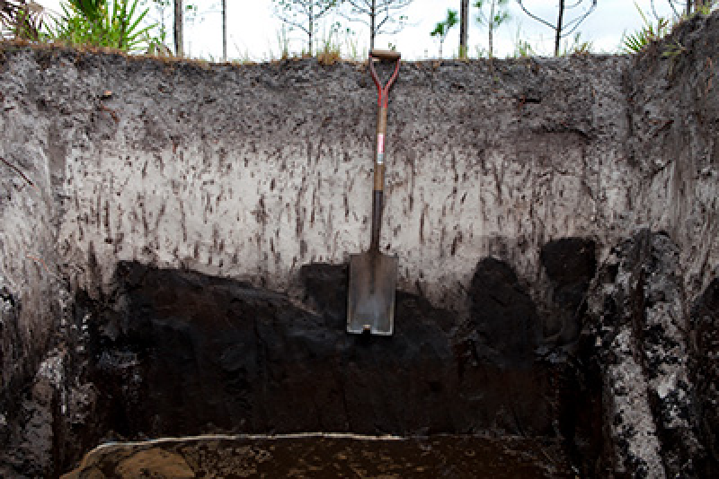
State 1
Hydric Flats
This state exist as flats on hydric lowlands throughout this MLRA. Plant communities are largely controlled by the influences of a shallow-ground water table and fire. Fire is an integral part of maintaining plant community composition and structure. A shallow-ground water table often attributes to hydric soil indicators and will be reflected in a dominant graminoid understory. Changes in long term hydroperiods may alter the state by losing of the ability to support hydric soil indicators, influencing understory vegetation. Changes in fire management may alter the community phase, influencing the overstory vegetation.
Community 1.1
Wet Grassland (Hydric)
These communities consist of treeless landscapes with a dense groundcover of grasses and forbs. Maintenance of these communities is dependent on frequent fire intervals estimated at every 1- to 2- years. This frequent interval is enough to maintain the grassy understory while creating suitable conditions for reproduction of several species and prevent the introduction of shrubs and pines into the system.
This community correlates with the Florida Natural Area Inventory community Wet Prairie (FNAI, 2010).
Forest understory. The forest understory consists of wiregrass (Aristida stricta), blue maidencane (Amphicarpum purshii), and/or hydrophytic species such as toothache grass (Ctenium aromaticum), Curtiss’ sandgrass (Calamovilfa curtissii), cutover muhly (Muhlenbergia expansa), coastalplain yellow-eyed grass (Xyris ambigua), Carolina redroot (Lachnanthes caroliana), beaksedges (Rhynchospora chapmanii, R. latifolia, R. compressa), and pitcherplants (Sarracenia spp.), among others. The understory will often form a dense groundcover of grasses and herbs and will be absent of bare openings due to absence of overstory shading. Downed woody debris is uncommon due to frequent fire return intervals, removing any excess ground fuel. Burned stump holes may be present, showing areas where living pine trees once occupied before transitioning to this community.
Community 1.2
Wet Pine Savanna (Hydric)
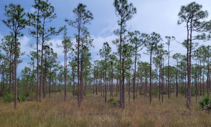
Figure 9. Savanna dominated by open overstory of pine species and understory of graminoids. 1697124558_113106
These communities consist of an open canopy of tall pines with a dense groundcover of grasses and forbs. Maintenance of these communities is dependent on frequent fire intervals estimated at every 1- to 3- years. This frequent interval is enough to maintain the grassy understory while creating suitable conditions for reproduction of several species. Longleaf pine is the principal canopy tree in the northern and central portion of this MLRA while Florida slash and slash pine form the principal canopy tree in the southern portion of this MLRA.
This community correlates with the Florida Natural Area Inventory community Wet Flatwoods (FNAI, 2010).
Forest overstory. The forest overstory often forms an open, scattered canopy of slash pine (Pinus elliottii), Florida slash pine (P. elliottii var densa), and/or longleaf pine (P. palustris). Subcanopy species may include scattered sweetbay (Magnolia virginiana), swamp bay (Persea palustris), loblolly bay (Gordonia lasianthus), pond cypress (Taxodium ascendens), dahoon (Ilex cassine), titi (Cyrilla racemiflora), cabbage palm (Sabal palmetto) and/or wax myrtle (Morella cerifera). The overstory pines may be stunted in size in areas of extreme wetness.
Forest understory. The forest understory consists of wiregrass (Aristida stricta), blue maidencane (Amphicarpum purshii), and/or hydrophytic species such as toothache grass (Ctenium aromaticum), Curtiss’ sandgrass (Calamovilfa curtissii), cutover muhly (Muhlenbergia expansa), coastalplain yellow-eyed grass (Xyris ambigua), Carolina redroot (Lachnanthes caroliana), beaksedges (Rhynchospora chapmanii, R. latifolia, R. compressa), and pitcherplants (Sarracenia spp.), among others. The understory will often form a dense groundcover of grasses and herbs and will be absent of bare openings due to high availability of light passing through the open pine canopy. Downed woody debris is uncommon due to frequent fire return intervals, removing any excess ground fuel.
Community 1.3
Fire Suppressed Stage
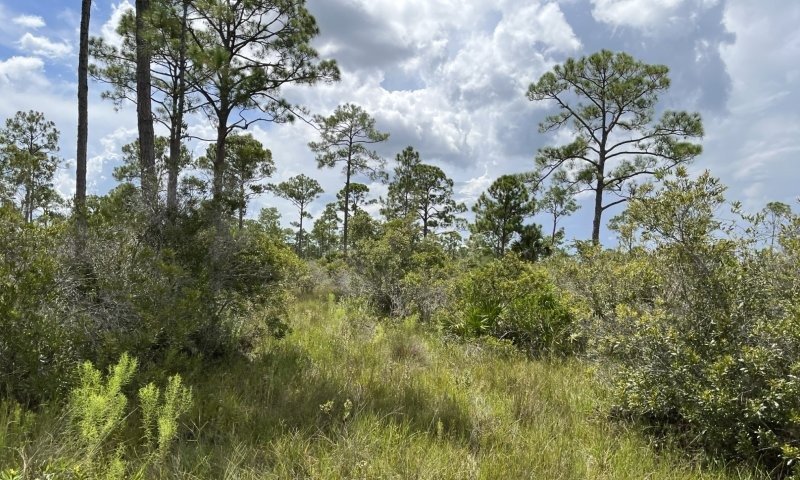
Figure 10. Fire suppressed stage allowing encroachment of shrubs in understory shading out graminoid. 1697131980_993559
This community has had fire excluded from its system long enough for shrub encroachment to begin in the understory. The unburned area will allow for shrubs to grow in height and density, shading the understory grasses and forbs and decreasing species diversity. Increases in shrub height can create a pathway for ladder fuels into the canopy if present, leading to the potential of canopy fires. If fire remains absent from this community for long periods of time hardwood encroachment may occur and form a closed canopy forest.
Community 1.4
Wet Oak Forest (Hydric)
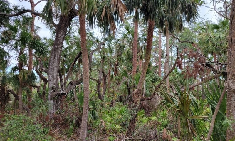
Figure 11. Forest dominated by a dense canopy of oaks and palms with a sparse to absent understory 1697124418_890172
These communities consist of closed canopy evergreen forests dominated primarily by oaks and palms with a sparse to absent groundcover of low shrubs and grasses. The groundcover will primarily consist of moist leaf litter as well as downed woody debris. Fire is usually absent from this state for this phase to become established, but may rarely enter from surrounding pyrogenic communities and extinguish itself. Maintenance of these communities is dependent on canopy gaps created by wind events such as hurricanes and tropical storms to allow light to penetrate the ground surface which will be rapidly recolonized by hardwoods.
This community correlates with the Florida Natural Area Inventory community Hydric Hammocks (FNAI, 2010).
Forest overstory. The forest overstory often forms a low closed canopy dominated by live oak (Quercus virginiana) with varying amounts of cabbage palm (Sabal palmetto). Other canopy species may include fully mature trees once present in the subcanopy or shrub layer of wet flatwoods. These may include sweetbay (Magnolia virginiana), swamp bay (Persea palustris), loblolly bay (Gordonia lasianthus), pond cypress (Taxodium ascendens), dahoon (Ilex cassine), titi (Cyrilla racemiflora), and/or wax myrtle (Morella cerifera). Shrubs are often uncommon but may include large gallberry (Ilex coriacea), fetterbush (Lyonia lucida), titi, black titi (Cliftonia monophylla), sweet pepperbush (Clethra alnifolia), red chokeberry (Photinia pyrifolia), and azaleas (Rhododendron canescens, R. viscosum). A relict emergent layer of pine species may be present. Arboreal epiphytes such as airplants (Tillandsia spp.) and mosses will be abundant on limbs and the trunks of overstory species.
Forest understory. The forest understory will be sparse to absent of herbaceous species due to high shading conditions created by the closed canopy. The groundcover will primarily consist of moist leaf litter as well as downed woody debris. In areas with enough light herbaceous species may consist of patchy areas of wiregrass (Aristida stricta), blue maidencane (Amphicarpum purshii), and/or hydrophytic species such as toothache grass (Ctenium aromaticum), Curtiss’ sandgrass (Calamovilfa curtissii), cutover muhly (Muhlenbergia expansa), coastalplain yellow-eyed grass (Xyris ambigua), Carolina redroot (Lachnanthes caroliana), beaksedges (Rhynchospora chapmanii, R. latifolia, R. compressa), and pitcherplants (Sarracenia spp.), among others.
Pathway 1.1A
Community 1.1 to 1.2
Pine becomes introduced and established in the community. Changes in fire frequency (from 1- to 2- years to 1- to 3- year intervals) may assist in allowing pine seedlings to become established and fire adapted before fire reenters the system. Pine introduction may be the result of natural seeding (animal dispersal) or anthropogenic influence (planting pine seedlings).
Pathway 1.1B
Community 1.1 to 1.3
Absence of fire from the system (estimated 5-10 years) may allow for the encroachment of understory shrubs, altering community composition.
Pathway 1.2A
Community 1.2 to 1.1
Removal of overstory pine species will create an open grassland habitat. This may happen naturally or anthropogenically. Changes in fire frequency (from 1- to 3- years to 1- to 2- year intervals) may prevent pine seedlings from becoming established and fire adapted.
Pathway 1.2B
Community 1.2 to 1.3
Wet Pine Savanna (Hydric)
Absence of fire from the system (estimated 5-10 years) may allow for the encroachment and growth of understory shrubs, altering community composition and structure and creating the potential for ladder fuels to enter the canopy and cause overstory mortality if fire is reintroduced.
Pathway 1.3A
Community 1.3 to 1.1
Fire is reintroduced to the system to its natural interval of 1- to 2- years. If fire is an unfeasible management practice, reduction of species may include methods of mechanical (mowing, cutting), chemical (herbicides), or biological removal
Pathway 1.3B
Community 1.3 to 1.2
Wet Pine Savanna (Hydric)
Fire is reintroduced to the system to its natural interval of 1- to 3- years. If fire is an unfeasible management practice, reduction of species may include methods of mechanical (mowing, cutting), chemical (herbicides), or biological removal
Pathway 1.3C
Community 1.3 to 1.4
Absence of fire from the system for long periods of time will allow for hardwood establishment in the overstory.
Pathway 1.4A
Community 1.4 to 1.1
Stand replacement may be the result of natural or anthropogenic affects. High intensity fire may cause overstory removal of species revert the stand back to an open shrubland condition. Logging of the overstory may create open conditions for shrubland reestablishment. Once removal of the overstory occurs reestablishment of regular low intensity fires (1- to 2-year intervals) may be needed to prevent reestablishment of overstory species.
State 2
Non-Hydric Flats
This state exist as flats on non-hydric (mesic) lowlands throughout this MLRA. Plant communities are largely controlled by the influences of fire more than the presence of a shallow-ground water table. Fire is an integral part of maintaining plant community composition and structure and will be reflected by dominantly mesic shrubs and interspersed graminoids. A shallow-ground water table may be present but will be less likely to influence species composition and structure. Changes in long term hydroperiods may alter the state by gaining of the ability to support hydric soil indicators, influencing understory vegetation. Changes in fire management may alter the community phase, influencing the overstory vegetation. These communities have been highly naturalized throughout the state and MLRA due to expansive changes in the ground water table.
Community 2.1
Mesic Palmetto Shrubland (Non-Hydric)
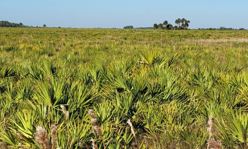
Figure 12. Palmetto Shrubland dominated by saw palmetto and grasses. 1697123509_266155
These communities consist of treeless landscapes with a dense groundcover of low shrubs and grasses. Maintenance of these communities is dependent on frequent fire intervals estimated at every 1 to 2 years. This frequent interval is enough to maintain the shrubby and grassy understory while creating suitable conditions for reproduction of several species and prevent the reintroduction of pines into the overstory.
This community correlates with the Florida Natural Area Inventory community Dry Prairie (FNAI, 2010).
Forest understory. Common shrubs are saw palmetto (Serenoa repens), which is often stunted, dwarf live oak (Quercus minima), gallberry (Ilex glabra), fetterbush (Lyonia lucida), shiny blueberry (Vaccinium myrsinites), netted pawpaw (Asimina reticulata), Atlantic St. John's wort (Hypericum reductum), dwarf wax myrtle (Morella cerifera var. pumila), and dwarf huckleberry (Gaylussacia dumosa). These are mixed with about an equal proportion of herbs, predominantly wiregrass (Aristida stricta), along with bottlebrush threeawn (Aristida spiciformis), hemlock witchgrass (Dichanthelium portoricense), broomsedge bluestem (Andropogon virginicus), lopsided indiangrass (Sorghastrum secundum), and cypress witchgrass (Dichanthelium ensifolium), plus numerous forbs including narrowleaf silkgrass (Pityopsis graminifolia), milkworts (Polygala spp.), meadowbeauties (Rhexia spp.), yellow-eyed grasses (Xyris spp.), and wild pennyroyal (Piloblephis rigida). The understory will often form a dense groundcover of shrubs and herbaceous species and will be absent of bare openings due to absence of overstory shading. Downed woody debris is uncommon due to frequent fire return intervals, removing any excess ground fuel. Burned stump holes may be present, showing areas where living pine trees once occupied before transitioning to this community.
Community 2.2
Mesic Pine Savanna (Non-Hydric)
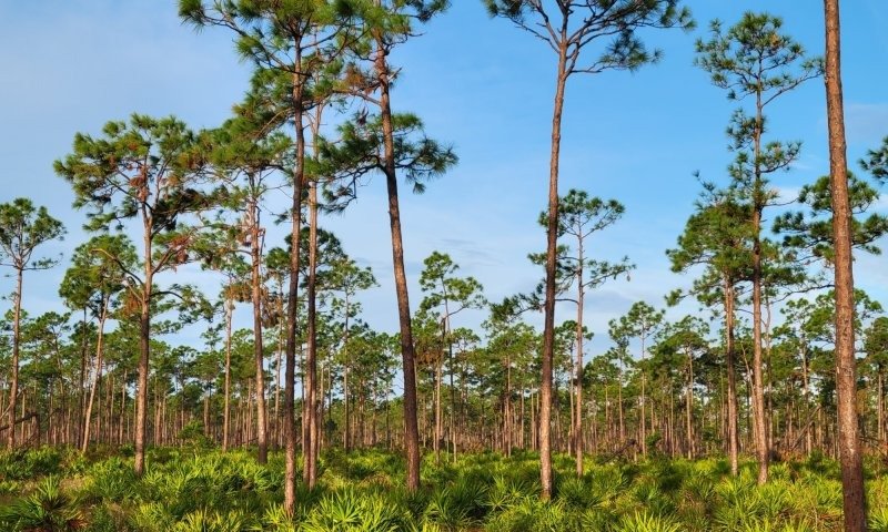
Figure 13. Savanna dominated by open overstory of pine species and understory of saw palmetto and grasses. 1697123594_310969
These communities consist of an open canopy of tall pines with a dense groundcover of low shrubs and grasses. Maintenance of these communities is dependent on frequent fire intervals estimated at every 2 to 4 years. This frequent interval is enough to maintain the shrubby and grassy understory while creating suitable conditions for reproduction of several species. Longleaf pine is the principal canopy tree in the northern and central portion of this MLRA while Florida slash and slash pine form the principal canopy tree in the southern portion of this MLRA.
This community correlates with the Florida Natural Area Inventory community Mesic Flatwoods (FNAI, 2010).
Forest overstory. The forest overstory often forms an open, scattered canopy of slash pine (Pinus elliottii), Florida slash pine (P. elliottii var densa), and/or longleaf pine (P. palustris). These pines are often the only overstory species in a well maintained community.
Forest understory. Characteristic shrubs include saw palmetto (Serenoa repens), gallberry (Ilex glabra), coastalplain staggerbush (Lyonia fruticosa), and fetterbush (Lyonia lucida). Rhizomatous dwarf shrubs, usually less than two feet tall, are common and include dwarf live oak (Quercus minima), runner oak (Q. pumila), shiny blueberry (Vaccinium myrsinites), Darrow's blueberry (V. darrowii), and dwarf huckleberry (Gaylussacia dumosa). The herbaceous layer is predominantly grasses, including wiregrass (Aristida stricta), dropseeds (Sporobolus curtissii, S. floridanus), panicgrasses (Dichanthelium spp.), and broomsedges (Andropogon spp.), plus a large number of showy forbs. The understory will often form a dense groundcover of shrubs and grasses due to high availability of light passing through the open pine canopy. Downed woody debris is uncommon due to frequent fire return intervals, removing any excess ground fuel. Saw palmetto trunks often grow horizontally along the surface rather than vertically and will often be very difficult to move through.
Community 2.3
Fire Suppressed Stage
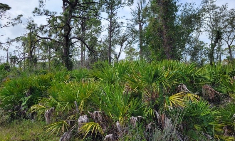
Figure 14. Fire suppressed stage of a pine savanna. Saw palmetto shrub height increases and creates ladder fuels into the canopy. 1697132220_997150
This community has had fire excluded from its system long enough for the understory shrubs to grow from the understory into the midstory. The unburned area will allow for shrubs to grow in height and density, shading the understory grasses and forbs and decreasing species diversity. Increases in shrub height can create a pathway for ladder fuels into the canopy if present, leading to the potential of canopy fires. If fire remains absent from this community for long periods of time the former dwarf hardwood tree species and shrubs may mature and form a closed canopy forest.
Community 2.4
Mesic Oak Forest (Non-Hydric)
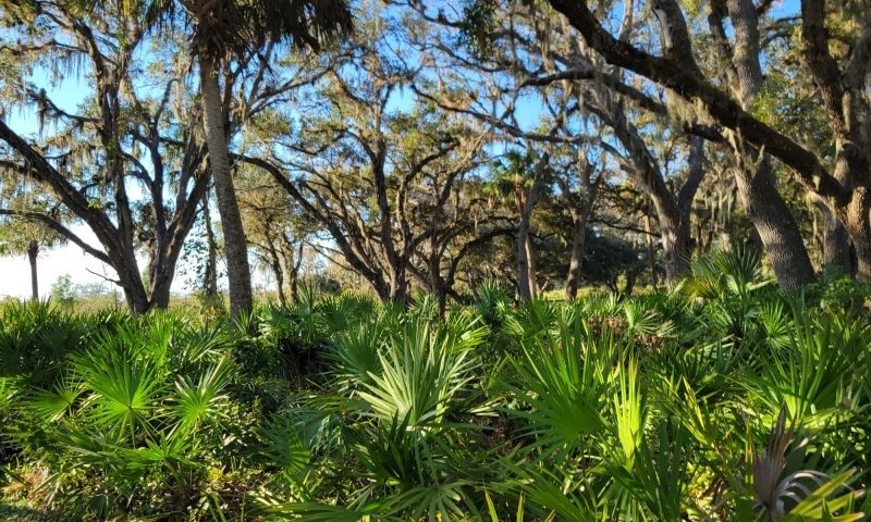
Figure 15. Forest dominated by a dense canopy of oaks and palms with a dense understory of saw palmetto and leaf litter. 1697123631_644114
These communities consist of closed canopy evergreen forests dominated primarily by oaks and palms with a sparse to dense groundcover of low shrubs. The groundcover will primarily consist of moist leaf litter as well as downed woody debris. Fire is usually absent from this state for this phase to become established, but may rarely enter from surrounding pyrogenic communities and extinguish itself. Maintenance of these communities is dependent on canopy gaps created by wind events such as hurricanes and tropical storms to allow light to penetrate the ground surface which will be rapidly recolonized by hardwoods.
This community correlates with the Florida Natural Area Inventory community Mesic Hammocks (FNAI, 2010).
Forest overstory. The overstory is often identified as low, closed canopy often dominated by live oak (Quercus virginiana) with varying amounts of cabbage palm (Sabal palmetto). Other canopy species may include fully mature trees once present in the subcanopy or shrub layer of mesic flatwoods. These may include Southern magnolia (Magnolia grandiflora) and pignut hickory (Carya glabra). Arboreal epiphytes such as airplants (Tillandsia spp.) and mosses will be abundant on limbs and the trunks of overstory species.
Forest understory. The shrubby understory may be dense or open, tall or short, and is typically composed of a mix of saw palmetto (Serenoa repens), American beautyberry (Callicarpa americana), American holly (Ilex opaca), gallberry (I. glabra), sparkleberry (Vaccinium arboreum), hog plum (Ximenia americana), common persimmon (Diospyros virginiana), highbush blueberry (Vaccinium corymbosum), Carolina laurelcherry (Prunus caroliniana), yaupon (I. vomitoria), wild olive (Osmanthus americanus), and/or wax myrtle (Morella cerifera). The herb layer is often sparse or patchy and consists of various graminoids, including low panic grasses (Panicum spp.), witchgrasses (Dichanthelium spp.), woodsgrass (Oplismenus hirtellus), longleaf woodoats (Chasmanthium laxum var. sessiliflorum), sedges (Cyperaceae), and whip nutrush (Scleria triglomerata), as well as various ferns and forbs such as bracken fern (Pteridium aquilinum) and partridgeberry (Mitchella repens). The groundcover will primarily consist of moist leaf litter as well as downed woody debris.
Pathway 2.1A
Community 2.1 to 2.2
Mesic Palmetto Shrubland (Non-Hydric)
Mesic Pine Savanna (Non-Hydric)
Pine becomes introduced and established in the community. Changes in fire frequency (from 1- to 2- years to 2- to 4- year intervals) may assist in allowing pine seedlings to become established and fire adapted before fire reenters the system. Pine introduction may be the result of natural seeding (animal dispersal) or anthropogenic influence (planting pine seedlings).
Pathway 2.1B
Community 2.1 to 2.3
Mesic Palmetto Shrubland (Non-Hydric)
Absence of fire from the system (estimated 5-10 years) may allow for the growth of understory shrubs, altering community structure.
Pathway 2.2A
Community 2.2 to 2.1
Mesic Pine Savanna (Non-Hydric)
Mesic Palmetto Shrubland (Non-Hydric)
Removal of overstory pine species will create an open shrubland habitat. This may happen naturally or anthropogenically. Changes in fire frequency (from 2- to 4- years to 1- to 2- year intervals) may prevent pine seedlings from becoming established and fire adapted.
Pathway 2.2B
Community 2.2 to 2.3
Mesic Pine Savanna (Non-Hydric)
Absence of fire from the system (estimated 5-10 years) may allow for the growth of understory shrubs, altering community structure and creating the potential for ladder fuels to enter the canopy and cause overstory mortality if fire is reintroduced.
Pathway 2.3A
Community 2.3 to 2.1
Mesic Palmetto Shrubland (Non-Hydric)
Fire is reintroduced to the system to its natural interval of 1- to 2- years. If fire is an unfeasible management practice, reduction of species may include methods of mechanical (mowing, cutting), chemical (herbicides), or biological removal
Pathway 2.3B
Community 2.3 to 2.2
Mesic Pine Savanna (Non-Hydric)
Fire is reintroduced to the system to its natural interval of 2- to 4- years. If fire is an unfeasible management practice, reduction of species may include methods of mechanical (mowing, cutting), chemical (herbicides), or biological removal
Pathway 2.3C
Community 2.3 to 2.4
Mesic Oak Forest (Non-Hydric)
Absence of fire from the system for long periods of time will allow for hardwood establishment in the overstory.
Pathway 2.4A
Community 2.4 to 2.1
Mesic Oak Forest (Non-Hydric)
Mesic Palmetto Shrubland (Non-Hydric)
Stand replacement may be the result of natural or anthropogenic affects. High intensity fire may cause overstory removal of species revert the stand back to an open shrubland condition. Logging of the overstory may create open conditions for shrubland reestablishment. Once removal of the overstory occurs reestablishment of regular low intensity fires (1- to 2-year intervals) may be needed to prevent reestablishment of overstory species.
State 3
Grazed Rangeland
Rangelands are described as lands on which the indigenous vegetation is predominately grasses, grass-like plants, forbs, and possibly shrubs or dispersed trees. Existing plant communities can include both native and introduced plants. Primary export from Florida ranges are cattle and have been present in the state since their first introduction by Spanish explorers in 1521. Native forage production is very good with proper management in this community, with only a slight effect on the community. Proper management will often result in an increase of grasses and reduction of shrubs while also maintaining proper fire intervals. Rangelands provide a diversity of ecosystems and also provide a diverse and significant production of economic benefits and ecosystem goods and services. Livestock production along with sustainable wildlife populations provide for the major direct economic benefits, but also tourism, recreational uses, minerals/energy production, renewable energy, and other natural resource uses can be very significant. Vital ecosystem contributions include clean water, clean air, fish/wildlife habitat, as well as intangible considerations such as historical, cultural, aesthetic and spiritual values. It is strongly advised that consultation with State Resource Conservationist and District Conservationists at local NRCS Service Centers be sought when assistance is needed in developing management recommendations or prescribed grazing practices.
Community 3.1
Lopsided Indiangrass –Bluestem – Toothache Grass - Blue Maidencane (RSG003- Excellent)
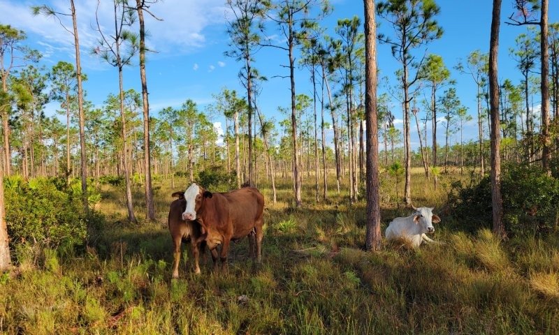
Figure 16. Rangeland dominated by graminoids
1697198576_941419
This phase represents the representative phase of the natural community that has been converted to rangeland in excellent conditions. This phase will have an open canopy with an open or shrubby understory dependent on the reference state. In excellent condition lopsided Indiangrass (Sorghastrum secundum), creeping bluestem (Schizachyrium stoloniferum), Chalky bluestem (Andropogon virginicus), toothache grass (Ctenium floridanum), and blue maidencane (Amphicarpum muhlenbergianum) species will provide the greatest portion of the forage production.
Resilience management. Proper range management of rotational grazing, burning, and mechanical brush control may improve the condition of a range. Rotation of cattle on range is important mostly for the maintenance of the range resource to ensure areas are not overgrazed.
Rotational burning is the oldest and perhaps the least expensive method to improve forage quality. The practice consists of burning different portions of the range at different times during the fall and winter and permitting cows to move to new burns. Burning should be consistent with natural fire return intervals of the community being grazed to prevent a shift in species composition. Burning and grazing can lead to range deterioration if not used properly. Forages must be allowed to regrow (no grazing) to restore vigor, and when cattle are allowed to graze regrowth, care must be taken to assure that these burned areas are not overgrazed, especially in May and June. Prescribed fire for range improvement will also benefit undesirable shrub control and improve wildlife habitat as well as hazardous fuel reduction.
Rotation is essential to exclude cattle after roller chopping for palmetto control. When desirable grasses, such as creeping bluestem, are present on range, they are usually found under the protection of the palmetto canopy. Chopping removes this canopy temporarily, and it is during this time that grasses have an opportunity to spread. Saw palmetto control is often an expansive range management practice and should be implemented after the creation of a grazing plan and the identification of desirable grasses in the system which will be grazed after the temporary removal of the palmetto.
Community 3.2
Wiregrass – Broomsedges - Saw Palmetto – Dwarf Oak (RSG003 – Poor to Fair)
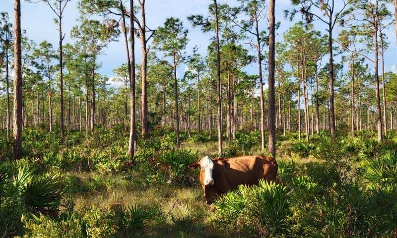
Figure 17. Rangeland dominated by saw palmetto and wiregrass
1697198541_324550
This phase represent the succession of rangeland in excellent condition to poor or fair conditions. The stage of this phase is the transitional period between a managed rangeland to a shrubby rangeland. Duration of this phase is dependent on former and future management, use, and impacts. This poor to fair condition phase will most often consist of the saw palmetto (Serenoa repens), wiregrass (Aristida stricta) and a dwarf variety of an oak (Quercus minima), dependent on the seedbank present. This phase often transitions due to poor management, including overstocking and overgrazing, as well as mismanagement of the natural habitat. Other undesirable species may be present in this community that have not been mentioned.
Pathway 3.1A
Community 3.1 to 3.2
Lopsided Indiangrass –Bluestem – Toothache Grass - Blue Maidencane (RSG003- Excellent)
Wiregrass – Broomsedges - Saw Palmetto – Dwarf Oak (RSG003 – Poor to Fair)
This pathway occurs when range management activities include overgrazing, overstocking, etc., natural succession of the once managed site leads to this stage.
Pathway 3.2A
Community 3.2 to 3.1
Wiregrass – Broomsedges - Saw Palmetto – Dwarf Oak (RSG003 – Poor to Fair)
Lopsided Indiangrass –Bluestem – Toothache Grass - Blue Maidencane (RSG003- Excellent)
This pathway represents renovation of the unmanaged condition back to managed rangeland in excellent condition. Management activities likely include mechanical removal of the larger, woody vegetation followed by herbicide treatment and establishment of desired seeding mixtures, and correcting grazing management plans.
State 4
Managed Grassland / Pastureland
Pasture is a land use type having vegetation cover comprised primarily of introduced or enhanced native forage species that is used for livestock grazing. Pasture vegetation can consist of grasses, legumes, other forbs, shrubs or a mixture. The majority of these forages are introduced, having originally come from areas in other states or continents. Most are now naturalized and are vital components of pasture based grazing systems. Pasture lands provide many benefits other than forage for livestock. Wildlife use pasture as shelter and for food sources. Well managed pasture captures rainwater that is slowly infiltrated into the soil which helps recharge groundwater. Many small pasture livestock operations are near urban areas providing vistas for everyone to enjoy. It is especially important as livestock managers continues to experience extraordinarily high fuel and other input costs. Overgrazed pastures can lead to soil compaction and numerous bare spots, which may then become focal points of accelerated erosion and colonization sites of undesirable plants or weeds. It is strongly advised that consultation with State Resource Conservationist and District Conservationists at local NRCS Service Centers be sought when assistance is needed in developing management recommendations or prescribed grazing practices. This grassland / pastureland state correlates with the 2013 Florida Forage Suitability Group G155XB141FL (Sandy Soils, on Flats on Mesic and Hydric Lowlands).
Community 4.1
Bahiagrass – Bermudagrass – Bluestem (FSG141)
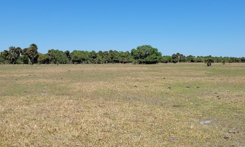
Figure 18. Pasture dominated by bahiagrass 1697198898_282854
This community phase represent commonly planted forage species on pasturelands, haylands, and open grasslands found in drained areas of this natural community. The suite of plants established on any given site may vary considerably depending upon purpose, management goals, and usage (e.g., horses vs. cattle). Most systems include a mixture of grasses and legumes that provide forage throughout the growing season. Warm season perennial forage species often include bahiagrass (Paspalum notatum), bermudagrass (Cynodon dactylon), stargrass (Cynodon nlemfuensis), limpograss (Hemarthria altissima), big bluestem (Andropogon gerardii), purple bluestem (Andropogon glomeratus var. glaucopsis), yellow indiangrass (Sorghastrum nutans), lopsided indiangrass (Sorghastrum secundum), switchgrass (Panicum virgatum), rhizoma perennial peanut (Arachis glabrata), and carpon desmodium (Desmodium heterocarpon). Warm season annual forage species often include browntop millet (Urochloa ramosa), pearl millet (Pennisetum glaucum), sorghum (Sorghum bicolor), hairy indigo (Indigofera hirsuta), and aeschynomene (Aeschynomene americana). Cool season annual forage species often include annual ryegrass (Lolium perenne ssp. multiflorum), oat (Avena sativa), rye (Secale cereale), wheat (Triticum aestivum), white clover (Trifolium repens) and Triticale (x Triticosecale rimpaui). Several additional plants and/or species combinations maybe present depending on the objectives and management approaches of the land manager/owner.
Resilience management. Surface and subsurface texture is predominantly fine sand or sandy soils with moderate water holding capacity, and a seasonal high water table ranging from 0 to 1 feet during wet periods. Soils are generally flat with a slope no greater than 2%, with very brief ponding following large seasonal rainfall events on some soils in this series. The ponding usually lasts less than 14 days with minimum to no negative impacts on production of adapted forage species. Irrigation and drainage is commonly used for crop production on these soils and can be found on old abandoned crop land converted to improved pastures; however, increases in forage yield related to drainage and irrigation are not well documented for these soils. Total production of all forage species is expected to be higher than other groups due to increased available water during the growing sea-son.
Use of cool season forages such as annual ryegrass, oats, and wheat planted in a prepared seedbed is dependent upon the location in the MLRA. Forage production is usually at the middle to lower end of the production range due to limited and sporadic rainfall during fall and winter months, particularly in the southern half of this MLRA. Additionally in the southern portion of the MLRA, warm temperatures persisting into the fall and returning quickly in the spring greatly shorten the production period for cool season forages. Thus, in the southern portion of the MLRA, cool season forages generally will only produce sufficient winter grazing in years with average and above average rainfall (El Nino winters) for specialized management uses such as creep grazing, early weaning, or purebred operations. While in more northerly locations in the MLRA, planting winter annual forages for use as a winter feed supply for the whole cow herd may be practical most years due to better winter rainfall. Overseeding annual ryegrass on a bahiagrass pasture also is not recommended in the southern end of this MLRA, due to excessive competition from bahiagrass for soil moisture, but may be an option in the northern portions of the MLRA.
Similarly winter legumes are less productive the further south in the MLRA the site is located. White clover is the only winter legume recommended for these sites due to its better tolerance to saturated soil conditions. Grazing management and fertilization need to favor the legume component for persistence. Even then, reseeding every other year may be necessary. White clover, which is normally considered a perennial species, functions more as an annual in Florida and thus is heavily dependent upon reseeding to persist. Due to bloat issue, white clover should be used only in mixtures unless bloat preventative treatments are fed.
Initial growth of perennial warm season grasses and legumes or establishment of warm season annual grasses may be delayed in the spring due to low rainfall. Often production of perennial species also dips during the April/May dry period. Once normal summer rainfall begins, plant production should resume. Warm season legumes such as aeschynomene and carpon desmodium can also be oversown onto warm season grasses in this forage suitability group, although fertilization (no N fertilizer) and grazing management needs to favor legume establishment and persistence. Additional lime may be needed to maintain a pH of 5.5 to 6.0. Improved grass varieties such as stargrass and limpograss may also be grown on these soils although stargrass is generally limited to the part of the MLRA south of the US I-4 corridor. Limpograss should be limited to soils where drainage has not been altered.
Dominant plant species
-
bahiagrass (Paspalum notatum), grass
-
Bermudagrass (Cynodon dactylon), grass
-
African Bermudagrass (Cynodon nlemfuensis), grass
-
limpograss (Hemarthria altissima), grass
-
big bluestem (Andropogon gerardii), grass
-
purple bluestem (Andropogon glaucopsis), grass
-
Indiangrass (Sorghastrum nutans), grass
-
lopsided Indiangrass (Sorghastrum secundum), grass
-
switchgrass (Panicum virgatum), grass
-
browntop millet (Urochloa ramosa), grass
-
pearl millet (Pennisetum glaucum), grass
-
sorghum (Sorghum bicolor), grass
-
Italian ryegrass (Lolium perenne ssp. multiflorum), grass
-
common oat (Avena sativa), grass
-
cereal rye (Secale cereale), grass
-
common wheat (Triticum aestivum), grass
-
triticale (Triticosecale rimpaui), grass
-
rhizoma peanut (Arachis glabrata), other herbaceous
-
carpon desmodium (Desmodium heterocarpon var. heterocarpon), other herbaceous
-
hairy indigo (Indigofera hirsuta), other herbaceous
-
shyleaf (Aeschynomene americana), other herbaceous
-
white clover (Trifolium repens), other herbaceous
Community 4.2
Dogfennel – Bunchgrass– Wax Myrtle (Unmanaged)
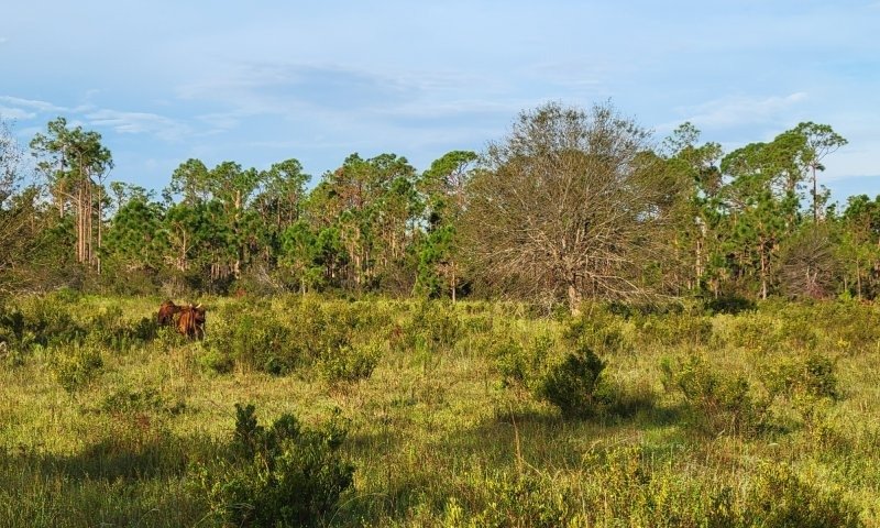
Figure 19. Pasture dominated by bunchgrass and wax myrtle 1697198666_112472
This phase represent the succession of pastureland and/or open grassland to unmanaged conditions. Duration of this phase is dependent on former and future management, use, and impacts. The early pioneer shrub thicket phase will be dependent on the available seedbank present. This unmanaged phase will most often consist of the shrub wax myrtle (Morella cerifera) and dogfennel (Eupatorium capillifolium), an aggressive native perennial that is characteristic of unimproved, unmanaged, or overgrazed pastures, where it adds the decline of forage yield and quality. Pasture grass present will enter a reproductive phase and have woody stems that are undesirable forage species. Other undesirable species may be present in this community that have not been mentioned,
Pathway 4.1A
Community 4.1 to 4.2
Bahiagrass – Bermudagrass – Bluestem (FSG141)
Dogfennel – Bunchgrass– Wax Myrtle (Unmanaged)
This pathway occurs when pasture management activities include overgrazing, overstocking, etc., natural succession of the once managed site leads to this stage.
Pathway 4.2A
Community 4.2 to 4.1
Dogfennel – Bunchgrass– Wax Myrtle (Unmanaged)
Bahiagrass – Bermudagrass – Bluestem (FSG141)
This pathway represents renovation of the unmanaged condition back to managed grassland / pasture in excellent condition. Management activities likely include mechanical removal of the larger, woody vegetation followed by herbicide treatment and establishment of desired seeding mixtures, and correcting grazing management plans.
State 5
Agricultural Commodities
The agriculture industry includes cultivated crops, aquaculture, and apiculture. Cultivated cropland includes areas used for the production of adapted crops for harvest. These areas comprise of land in row crops or close-grown crops that are in a rotation with row or close-grown crops. Primary exports from Florida consist of fruits, greenhouse and nursery products, sugar cane, and the signature export of citrus. Aquaculture includes the cultivation and maintenance of aquatic plants, aquatic reptiles, crustaceans, food/ ornamental fish, shellfish, and other miscellaneous species for harvesting. Apiculture includes the maintenance of honeybees and hives to provide beeswax, honey/ other edible bee products, crop pollination services, and sales of bees to other beekeepers. These areas have been modified resulting in land clearing practices and hydrologic management to fit the growers needs. It is strongly advised that consultation with State Agronomist and District Conservationists at local NRCS Service Centers be sought when assistance is needed in developing management recommendations.
Resilience management. Major natural resource concerns facing cropland include: (1) erosion by wind and water, (2) maintaining and enhancing soil quality, (3) water quality from nutrient and pesticides runoff and leaching, and (4) managing the quantity of water available for irrigation. For more specific information regarding cropland please contact your local NRCS office.
Community 5.1
Vegetables
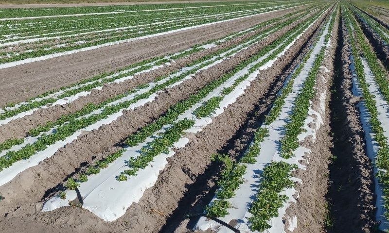
Figure 20. Celery fields 1697198967_105302
This phase describes the growth and harvest of vegetables. Land conversion may be necessary to create fields suitable for crop growth. Common vegetables grown in these soils include Cabbage, Celery, Cucumber, Peppers, Irish Potatoes, Summer Squash, and Tomatoes. Due to the year-round warm climate Florida has, vegetables can often be harvested in both winter and summer seasons.
Resilience management. Selection of species and varieties is critical for vegetable production, as plants that are not adapted to local conditions will generally fail to produce regardless of how much care and attention they receive. Weather is perhaps the single most important factor that determines where crops can be grown. Winters may be too cold for some vegetables or too short for others. Still other crops may suffer from summer's heat and humidity. Consequently, species and varieties should be chosen on the basis of historical weather patterns. It is strongly advised that consultation with State Agronomist and District Conservationists at local NRCS Service Centers be sought when assistance is needed in developing management recommendations.
Community 5.2
Non-Citrus Fruits and Nuts
This phase describes the growth and harvest of fruits. Land conversion may be necessary to create fields suitable for crop growth. Common fruits grown in these soils include Strawberries and Watermelons. Due to the year-round warm climate Florida has, fruits can often be harvested in both winter and summer seasons.
Resilience management. Selection of species and varieties is critical for fruit production, as plants that are not adapted to local conditions will generally fail to produce regardless of how much care and attention they receive. Weather is perhaps the single most important factor that determines where fruit crops can be grown. Winters may be too cold for some fruit or too short for others. Still other fruit may suffer from summer's heat and humidity. Consequently, species and varieties of fruits should be chosen on the basis of historical weather patterns. It is strongly advised that consultation with State Agronomist and District Conservationists at local NRCS Service Centers besought when assistance is needed in developing management recommendations.
Community 5.3
Grasses / Grain Crops
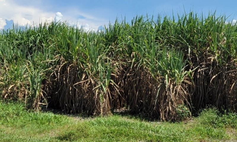
Figure 21. Sugar cane fields 1697198994_405208
This phase describes the growth and harvest of grass-like agricultural products and grain crops used for silage. Land conversion may be necessary to create fields suitable for crop growth. Common species grown in these soils include Corn, Sweet Corn, Grain Sorghum, Improved Bermudagrass Hay, Sorghum Silage, Soybeans, Sugarcane, and Tobacco. Due to the year-round warm climate Florida has, these species can often be grown and harvested in both winter and summer seasons.
Resilience management. Selection of species and varieties is critical for grass and grain production, as plants that are not adapted to local conditions will generally fail to produce regardless of how much care and attention they receive. Weather is perhaps the single most important factor that determines where fruit crops can be grown. Winters may be too cold for some crops or too short for others. Still other crops may suffer from summer's heat and humidity. Consequently, species and varieties of crop should be chosen on the basis of historical weather patterns. It is strongly advised that consultation with State Agronomist and District Conservationists at local NRCS Service Centers be sought when assistance is needed in developing management recommendations.
Community 5.4
Citrus Fruits
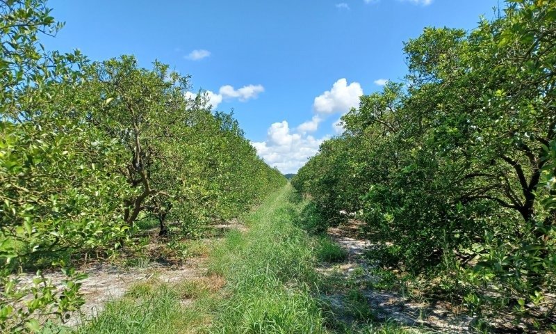
Figure 22. Citrus grove in excellent conditions 1697199019_875850
This phase describes the growth of citrus crops, dominantly identified as oranges and grapefruit within this ecological site area. This phase differs from other fruits and tree crops due to the intensive management and care needed for citrus groves. Citrus is one of the highest commercial agriculture products in the state of Florida.
Resilience management. Management should be based off individual groves, as different areas will require different management. It is strongly advised that consultation with State Agronomist and District Conservationists at local NRCS Service Centers be sought when assistance is needed in developing management recommendations.
Community 5.5
Abandoned Agriculture Fields
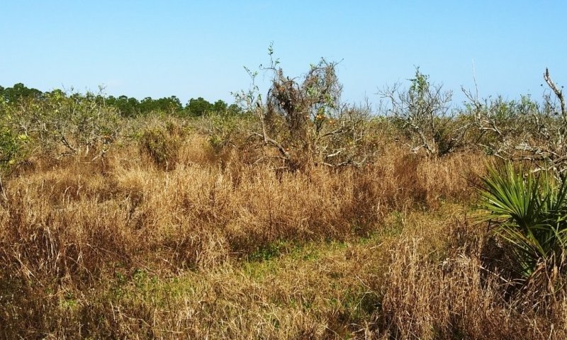
Figure 23. Abandoned grove 1697199048_162208
This phase describes the absence of management from agriculture fields, often resulting in overgrowth of woody shrubs and vines as well as invasive weeds. This community may occur when producers abandon a field due to any number of reasons. Many fields in the first seasons of abandonment will remain fallow until weedy and shrubby species become dominant. With proper management this community has the potential to support agricultural commodities.
Pathway 5.1A
Community 5.1 to 5.2
The conversion from vegetable crops to non-citrus fruit and nut crops would require, if applicable, the harvest of the crop before converting the land for the desired crop production. Mechanical ground preparation and chemical applications may be needed to create the desired land use conditions for the new crop.
Pathway 5.1B
Community 5.1 to 5.3
The conversion from vegetable crops to grasses/ grain crop would require, if applicable, the harvest of the crop before converting the land for the desired crop production. Mechanical ground preparation and chemical applications may be needed to create the desired land use conditions for the new crop.
Pathway 5.1C
Community 5.1 to 5.4
The conversion from vegetable crops to citrus crop would require, if applicable, the harvest of the crop before converting the land for the desired crop production. Mechanical ground preparation and chemical applications may be needed to create the desired land use conditions for the new crop.
Pathway 5.1D
Community 5.1 to 5.5
Abandoned Agriculture Fields
Many fields become abandoned when a producer doesn't maintain and harvest crops against pests, diseases, rising costs of labor, or any other reason that will lead to field abandonment.
Pathway 5.2A
Community 5.2 to 5.1
The conversion from non-citrus fruit and nut crops to vegetable crops would require, if applicable, the harvest of the crop before converting the land for the desired crop production. Mechanical ground preparation and chemical applications may be needed to create the desired land use conditions for the new crop.
Pathway 5.2B
Community 5.2 to 5.3
The conversion from non-citrus fruit and nut crops to grasses / grain crops would require, if applicable, the harvest of the crop before converting the land for the desired crop production. Mechanical ground preparation and chemical applications may be needed to create the desired land use conditions for the new crop.
Pathway 5.3C
Community 5.2 to 5.4
The conversion from non-citrus fruit and nut crops to citrus crops would require, if applicable, the harvest of the crop before converting the land for the desired crop production. Mechanical ground preparation and chemical applications may be needed to create the desired land use conditions for the new crop.
Pathway 5.2D
Community 5.2 to 5.5
Many fields become abandoned when a producer doesn't maintain and harvest crops against pests, diseases, rising costs of labor, or any other reason that will lead to field abandonment.
Pathway 5.3A
Community 5.3 to 5.1
The conversion from grasses and grain crops to vegetable crops would require, if applicable, the harvest of the crop before converting the land for the desired crop production. Mechanical ground preparation and chemical applications may be needed to create the desired land use conditions for the new crop.
Pathway 5.3B
Community 5.3 to 5.2
The conversion from grasses and grain crops to non-citrus fruit and nut crops would require, if applicable, the harvest of the crop before converting the land for the desired crop production. Mechanical ground preparation and chemical applications may be needed to create the desired land use conditions for the new crop.
Pathway 5.3C
Community 5.3 to 5.4
The conversion from grasses and grain crops to citrus crops would require, if applicable, the harvest of the crop before converting the land for the desired crop production. Mechanical ground preparation and chemical applications may be needed to create the desired land use conditions for the new crop.
Pathway 5.3D
Community 5.3 to 5.5
Abandoned Agriculture Fields
Many fields become abandoned when a producer doesn't maintain and harvest crops against pests, diseases, rising costs of labor, or any other reason that will lead to field abandonment.
Pathway 5.4A
Community 5.4 to 5.1
The conversion from citrus crops to vegetable crops would require, if applicable, the harvest of the crop before converting the land for the desired crop production. Mechanical ground preparation and chemical applications may be needed to create the desired land use conditions for the new crop.
Pathway 5.4B
Community 5.4 to 5.2
The conversion from citrus crops to non-citrus fruit and nut crops would require, if applicable, the harvest of the crop before converting the land for the desired crop production. Mechanical ground preparation and chemical applications may be needed to create the desired land use conditions for the new crop.
Pathway 5.4C
Community 5.4 to 5.3
The conversion from citrus crops to grasses / grain crops would require, if applicable, the harvest of the crop before converting the land for the desired crop production. Mechanical ground preparation and chemical applications may be needed to create the desired land use conditions for the new crop.
Pathway 5.4D
Community 5.4 to 5.5
Abandoned Agriculture Fields
Many fields become abandoned when a producer doesn't maintain and harvest crops against pests, diseases, rising costs of labor, or any other reason that will lead to field abandonment. Major diseases affecting citrus groves include citrus canker, an infection that causes lesions on the leaves, stems and fruits of citrus crops, as well as citrus greening, often spread by the Asian citrus psyllid, a sap-sucking hemipteran bug that causes trees to produce fruits that are green, misshapen and bitter, and unsuitable for sale as fresh fruit or juice.
Pathway 5.5A
Community 5.5 to 5.1
Abandoned Agriculture Fields
The restoration of an abandoned field or grove to an active agriculture field often includes removal of the abandoned crop and weeds, converting the land if necessary, and replanting of desired species. Abandoned citrus groves that get converted to agriculture fields will often need complete removal of the citrus tree and the land to be flattened from furrows present in citrus groves. Once removal of undesirable species is complete and the land is converted to a flat field (if necessary), and new seedlings are planted, maintenance is required to keep the crop healthy until harvest.
Pathway 5.5B
Community 5.5 to 5.2
The restoration of an abandoned field or grove to an active agriculture field often includes removal of the abandoned crop and weeds, converting the land if necessary, and replanting of desired species. Abandoned citrus groves that get converted to agriculture fields will often need complete removal of the citrus tree and the land to be flattened from furrows present in citrus groves. Once removal of undesirable species is complete and the land is converted to a flat field (if necessary), and new seedlings are planted, maintenance is required to keep the crop healthy until harvest.
Pathway 5.5C
Community 5.5 to 5.3
Abandoned Agriculture Fields
The restoration of an abandoned field or grove to an active agriculture field often includes removal of the abandoned crop and weeds, converting the land if necessary, and replanting of desired species. Abandoned citrus groves that get converted to agriculture fields will often need complete removal of the citrus tree and the land to be flattened from furrows present in citrus groves. Once removal of undesirable species is complete and the land is converted to a flat field (if necessary), and new seedlings are planted, maintenance is required to keep the crop healthy until harvest.
Pathway 5.5D
Community 5.5 to 5.4
Abandoned Agriculture Fields
The restoration of an abandoned field or grove to an active citrus grove often includes removal of the abandoned crop and weeds and replanting of desired species. In citrus groves removal of abandoned citrus trees are often either completely pulled out of the ground or cut to the stump and new seedlings are planted next to the cut stumps. Once removal of undesirable species is complete and new resets are planted, maintenance is required to keep the crop healthy until harvest.
State 6
Silviculture
This state is important and used by silviculturists, landowners, land managers, and the public/private industry. Silviculture is land used in controlling the establishment, growth, composition, health, and quality of forests and woodlands to meet the diverse needs and values of landowners and society such as wildlife habitat, timber, water resources, restoration, and recreation on a sustainable basis. These are forestry practices that include thinning, harvesting, planting, pruning, prescribed burning and site preparation, for managed goals such as wildlife habitat creation or harvesting. Many managed silvicultural lands in Florida include tree plantations for growth of tropical ornamental species such as palms; and lumber, pulp, and paper species such as slash pine, longleaf pine, ornamentals, and eucalyptus.
Resilience management. This state is managed by silviculture prescriptions that will vary based on individual forest stand and management goals.
Community 6.1
Longleaf Pine (Pinus palustris) Managed Stand
This phase describes the cultivation and harvesting of pine, dominantly longleaf pine. These are valued timber species that are suitable for the well-drained soils with high drought tolerance once established. Thick bark helps these trees be very resistance to ground fires and can stimulate height-growth by reducing competition of understory species. Mature stands can be harvested in 40 to 50 years for lumber, often used for utility poles and lumber.
Resilience management. Longleaf pine is classified as fire-resistant. The natural fire interval is every year to every 5 to 10 years through lighting strikes in the late spring to early summer months. Young stands should not be burned until at least 2 years after the removal cut to allow time for logging slash to decay and the seedlings to respond to release. Natural regeneration of longleaf pine is difficult due to poor seed production, heavy seed predation by animals, poor seedling survival, and slow seedling growth.
It is strongly advised that consultation with State Forester and District Conservationists at local NRCS Service Centers be sought when assistance is needed in developing management recommendations.
Community 6.2
Slash pine (Pinus elliottii) – South Florida Slash Pine (Pinus elliottii var densa) Managed Stand
This phase describes the cultivation and harvesting of pine, dominantly slash pine and Florida slash pine (dominant in southern half of this MLRA). These are valued timber species that are suitable for less well-drained soils and a high seasonal water table. Thick bark helps these trees be very resistance to ground fires and can stimulate height-growth by reducing competition of understory species. Mature stands can be harvested in 25 to 40 years for lumber, often used for utility poles, railroad ties, pilings and lumber.
Resilience management. In a slash pine silvicultural stand, a fire interval of at least 5 to 6 years allows young trees to develop some fir resistance. When fire comes through, it exposes the mineral soil which enhances germination. One- and two-year-old slash pine are killed by low-severity fire. After 3 to 4 years, seedlings survive low-severity fire but not moderate-severity fire. Ten- to fifteen-foot-tall saplings survive moderate-severity fires. Once slash pine is 10 to 12 years old, it survives fire that does not reach the crown. A drainage system such as bedding may be needed to mitigate the effects of the seasonal high water table found in these areas. Shallow bedding has occasionally been seen to fail on pine plantations of more wet drainage classes. The solution to this may be to establish deeper beds for better drainage.
It is strongly advised that consultation with State Forester and District Conservationists at local NRCS Service Centers be sought when assistance is needed in developing management recommendations.
Community 6.3
Eucalyptus (Eucalyptus spp.) Managed Stand
Eucalyptus stands have been commercially planted statewide in Florida since the 1960s, and pose little threat of spreading from managed plantations into natural communities. Multiple species of Eucalyptus species can be grown in Florida, including Eucalyptus grandis, E.grandis x E. urophylla, E. benthamii, and E. amplifolia. These are fast-growing trees that, when managed properly, produce commercial products such as mulch wood, pulpwood, energywood, and bioproducts, as well as being used as phytoremediation systems and windbreaks from citrus and vegetable crops.
Resilience management. These are highly adaptable species, and can be grown on poor quality sites if amendments are added to raise nutrient levels and / or pH, but typically do best on well drained sandy soils. Management needs will vary based on the desired use for the Eucalyptus species, but all will survive and grow best when competing vegetation is well controlled during the first two years of planting.
It is strongly advised that consultation with State Forester and District Conservationists at local NRCS Service Centers be sought when assistance is needed in developing management recommendations.
Community 6.4
Palm Managed Stand
This phase describes the growth, management and harvesting of different palm species for various uses. The main use of palm species within Florida are used as interior and exterior landscape ornamentals. Other markets for palm species include seed production and cut palm frond production. It is important to determine the potential market before the nursery is put into production as management and set up costs may vary by species. Many species cannot be produced when freezing temperatures are experienced and palm species must be chosen in occurrence to local temperature zones.
Resilience management. Palm species are adaptable to a wide range of soil types for field production of palms. Palms may grow best when sites are well drained to provide adequate aeration for root growth and easy harvest during periods of heavy rains. Palms that will be mechanically harvests must have sufficient room between rows and plants for machinery access without damaging existing trees, but if the palms are harvested manually a higher planting density can be implemented. Irrigation and fertilization in a palm field will depend on the local soils and hydroperiods, as well as chosen desired species, age, and stand density. Use of pesticides and herbicides can help minimize competition from weeds and undesirable pests which may cause damage to a stand or nursery.
It is strongly advised that consultation with State Forester and District Conservationists at local NRCS Service Centers be sought when assistance is needed in developing management recommendations.
State 7
Invaded State
This state represents the dominance of one or multiple non-native or exotic species which outcompetes the native natural community and may significantly alter the composition and structure of the invaded stand by overshading the canopy and understory components and preventing regeneration of native species.
Community 7.1
Melaleuca – Brazilian Peppertree – Cogon Grass
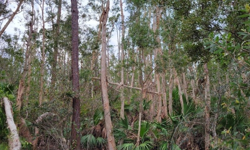
Figure 24. Savanna phase invaded by Melaleuca quinquenervia 1697199160_896374
This phase describes the introduction and establishment of invasive species common to this ecological site; Brazilian peppertree (Schinus terebinthifolia), cogon grass (Imperata cylindrica), and melaleuca (Melaleuca quinquenervia). These are fire tolerant shrubs (Brazilian peppertree), grasses (Cogon grass), and trees (Melaleuca) that will outcompete native plants of this ecological site. These species are adapted to the stressors common in pine flatwoods systems, including the seasonal high-water tables and frequent fire. Other undesirable species may be present in this community that have not been mentioned,
Resilience management. Restoring native habitat may be very difficult with these species. Specific management plans may be required to identify and manage these species. It is strongly advised that consultation with State Resource Conservationist and District Conservationists at local NRCS Service Centers be sought when assistance is needed in developing management recommendations or invasive control practices.
State 8
Human Altered and Human Transported Areas
These areas include soils that were intentionally and substantially modified by humans for an intended purpose, commonly for terraced agriculture, building support, mining, transportation, and commerce. The alteration is of sufficient magnitude to result in the introduction of a new parent material (human-transported material) or a profound change in the previously existing parent material (human-altered material).They do not include soils modified through standard agricultural practices or farmed soils with unintended wind and water erosion. When a soil is on or above an anthropogenic landform or microfeature, it can be definitely be associated with human activity and is assigned to a unique taxa, usually found as an Urban land complex within that communities natural soil properties (e.g, Myakka fine sand-Urban land complex, 0 to 2 percent slopes).
Characteristics and indicators. Evidence of these areas include soils with manufactured items (e.g. artifacts) present in the profile, human altered-materials (e.g., deeply excavated or deeply plowed soil) or human-transported material (e.g., fill), and position on or above anthropogenic landforms (e.g., flood-control levees) and microfeatures (e.g., drainage ditches). Detailed criteria regarding the identification of anthropogenic (artificial) landforms, human-altered materials, and human-transported material are in the Keys to Soil Taxonomy (Soil Survey Staff, 2014).
Community 8.1
Reclaimed Areas
Reclaimed areas are areas that have been modified through anthropogenic means that are restored to a natural or second-hand natural community. Areas that can be reclaimed are any intensity urban areas and may be required to be reclaimed after urban use (e.g., active mines must be reclaimed). These practices include the identification, removal, and stockpiling soil materials before altering the land, and revegetation and replacement of soil materials after altering the land. This also applies to nearby urban areas that have been adversely affected by the anthropogenic activities.
Community 8.2
Urban Areas
This urban community consists of development for human use. Urban areas include a variety of land uses, e.g., inner city or urban core, industrial and residential areas, cemeteries, parks, and other open spaces; the overall function which may benefit the quality of human life. These often form an urban soil mosaic, where the natural landscape has been fragmented into parcels with distinctive disturbance and management regimes and, as a result, distinctive characteristic soil properties.
Resilience management. Within this community there are three different levels of urbanization, based off population dynamics, residential density, and intensity of development. These are labeled as low-intensity, medium-intensity, and high-intensity urban areas, which can eventually be split apart into its own separate state. Low-intensity urban areas may consist of single dwelling homes with little impact on the surrounding community which still somewhat represents the natural community (e.g., represents natural landscape, hydrology, and vegetation) , other examples of this are urban parks, cemeteries, or campgrounds with little urban development. Medium-intensity urban areas consist of larger urban dwellings with some natural features but have been modified to meet urban needs (e.g., towns). High-intensity urban areas are areas of heavily modified areas with complete alterations of the natural landscape, hydrology, and vegetation to support a very large population, which once constructed is permanently altered (e.g., metropolis areas/ active mines).
Community 8.3
Non-Reclaimed Areas
Non-reclaimed areas are areas that have been modified through anthropogenic means that are unable to be restored to a natural or semi-natural community. Areas that cannot be reclaimed are areas under active mining status (phosphate, sand, or gravel mines)or mined areas before the Phosphate Land Reclamation Act in 1975, which leaves shut down operations alone. These areas also include fallow mines that have been flooded and are now permanent bodies of water.
Community 8.4
Landfills
This is an anthropogenic site for the disposal of waste material. It includes manufactured layers (artificial, root limiting layer below the soil surface) that are representative of human altered and human transported sites. These layers are often alternative between natural fill material and geotextile liners, asphalt, concrete, rubber or plastic that are built up and can rise above the surrounding landscape by 30meters or more often impeding water, gas, or roots from moving through the profile.
Pathway 8.1A
Community 8.1 to 8.2
This transition is driven by clearing and developing the land for low-, medium-, or high-intensity urban areas.
Pathway 8.1B
Community 8.1 to 8.4
This transition is driven by the deposition of manufactured layers along with anthropogenic waste which is consistently built upon.
Pathway 8.2A
Community 8.2 to 8.1
This transition is driven by the revegetation, reestablished hydroperiods, and replacement of displaced soil materials after urbanization of the land.
Pathway 8.2B
Community 8.2 to 8.3
This transition is driven by heavy industrial or urban development which causes the land to become non-reclaimable. This transition is rare due to the many environmental laws and regulations that must be followed when developing land.
Pathway 8.2C
Community 8.2 to 8.4
This transition is driven by the deposition of manufactured layers along with anthropogenic waste which is consistently built upon.
Pathway 8.3A
Community 8.3 to 8.1
This transition is driven by the revegetation, reestablished hydroperiods, and replacement of displaced soil materials after urbanization of the land.
Transition T1A
State 1 to 2
This is driven by the loss of the hydroperiod needed to maintain and support hydric soil indicators. This is seen widely throughout the state as landscapes are intentionally drained for urban and agricultural purposes or are the unintentional result of landscape drainage. Historical satellite imagery from the 1940s and 1950s often show large tracts of open grasslands (State/Phase 1.1) that have been altered due to changes in hydrology which now support non-hydric poorly drained plant communities (State 2).
Transition T1B
State 1 to 3
This mechanism is driven by the introduction of livestock species to the natural system and implementing a planned grazing strategy. Use of a planned grazing strategy to balance animal forage demand with available forage resources. Timing, duration, and frequency of grazing are controlled and some type of grazing rotation is applied to allow for plant recovery following grazing. It is strongly advised that consultation with State Resource Conservationist and District Conservationists at local NRCS Service Centers be sought when assistance is needed in developing management recommendations or prescribed grazing practices.
Transition T1C
State 1 to 4
Actions required to convert native habitat to pasture or forage production include herbicide application, seedbed preparation, and the establishment of desired plants. Decisions to convert native land to pastureland on this site should be made carefully and continuously evaluated before, during, and after conversion activities. This site is extremely susceptible to soil compaction and erosion. The decision to proceed with this action should be done so in close communication with and guidance from local NRCS Service Centers.
Transition T1D
State 1 to 5
Actions required to convert native habitat to agricultural land include herbicide application, seedbed preparation, and the establishment of desired plants. Decisions to convert land to agriculture on this site should be made carefully and continuously evaluated before, during, and after conversion activities. The decision to proceed with this action should be done so in close communication with and guidance from local NRCS Service Centers.
Transition T1E
State 1 to 6
This pathway consists of prescribed silvicultural activities specifically designed to meet stand compositional and production objectives. Decisions to convert native land to forestry plantations on this site should be made carefully and continuously evaluated before, during, and after conversion activities. This pathway consists of prescribed silvicultural activities specifically designed to meet stand compositional and production objectives.
Transition T1F
State 1 to 7
This transition represents proliferation and dominance of an invasive species. Soil mechanical disturbances can compound this effect and create suitable conditions for invasive species.
Transition T1G
State 1 to 8
This transition is driven by the alteration and/ or transportation of soil materials via anthropogenic means.
Restoration pathway R2A
State 2 to 1
This is driven by gaining the hydroperiod needed to maintain and support hydric soil indicators. Once these soil conditions are met this area has the potential to support reference ground cover species composition and structure. Reseeding of native graminoid species to the reference state and removal of excess undesirable species may be required. If wildlife poses a potential threat to restoration some method of control should be used, either repeated intense removal periods of fencing. Fire return intervals should be reintroduced according to the desired community interval period.
Transition T2A
State 2 to 3
This mechanism is driven by the introduction of livestock species to the natural system and implementing a planned grazing strategy. Use of a planned grazing strategy to balance animal forage demand with available forage resources. Timing, duration, and frequency of grazing are controlled and some type of grazing rotation is applied to allow for plant recovery following grazing. It is strongly advised that consultation with State Resource Conservationist and District Conservationists at local NRCS Service Centers be sought when assistance is needed in developing management recommendations or prescribed grazing practices.
Transition T2B
State 2 to 4
Actions required to convert native habitat to pasture or forage production include herbicide application, seedbed preparation, and the establishment of desired plants. Decisions to convert native land to pastureland on this site should be made carefully and continuously evaluated before, during, and after conversion activities. This site is extremely susceptible to soil compaction and erosion. The decision to proceed with this action should be done so in close communication with and guidance from local NRCS Service Centers.
Transition T2C
State 2 to 5
Actions required to convert native habitat to agricultural land include herbicide application, seedbed preparation, and the establishment of desired plants. Decisions to convert land to agriculture on this site should be made carefully and continuously evaluated before, during, and after conversion activities. The decision to proceed with this action should be done so in close communication with and guidance from local NRCS Service Centers.
Transition T2D
State 2 to 6
This pathway consists of prescribed silvicultural activities specifically designed to meet stand compositional and production objectives. Decisions to convert native land to forestry plantations on this site should be made carefully and continuously evaluated before, during, and after conversion activities. This pathway consists of prescribed silvicultural activities specifically designed to meet stand compositional and production objectives.
Transition T2E
State 2 to 7
This transition represents proliferation and dominance of an invasive species. Soil mechanical disturbances can compound this effect and create suitable conditions for invasive species.
Transition T2F
State 2 to 8
This transition is driven by the alteration and/ or transportation of soil materials via anthropogenic means.
Transition T3A
State 3 to 1
This transition is driven by the removal of domesticated grazing species from the system and reintroduction of natural management strategies.
Transition T3B
State 3 to 2
This transition is driven by the removal of domesticated grazing species from the system and reintroduction of natural management strategies.
Transition T3C
State 3 to 4
Actions required to convert altered land use to pasture or forage production include herbicide application, seedbed preparation, and the establishment of desired plants. Decisions to convert to pastureland on this site should be made carefully and continuously evaluated before, during, and after conversion activities. This site is extremely susceptible to soil compaction and erosion. The decision to proceed with this action should be done so in close communication with and guidance from local NRCS Service Centers.
Transition T3D
State 3 to 5
Actions required to convert altered land use to agricultural land include herbicide application, seedbed preparation, and the establishment of desired plants. Decisions to convert land to agriculture on this site should be made carefully and continuously evaluated before, during, and after conversion activities. The decision to proceed with this action should be done so in close communication with and guidance from local NRCS Service Centers.
Transition T3E
State 3 to 6
This pathway consists of prescribed silvicultural activities specifically designed to meet stand compositional and production objectives. Decisions to convert altered land use to forestry plantations on this site should be made carefully and continuously evaluated before, during, and after conversion activities. This pathway consists of prescribed silvicultural activities specifically designed to meet stand compositional and production objectives.
Transition T3F
State 3 to 7
This transition represents proliferation and dominance of an invasive species. Soil mechanical disturbances can compound this effect and create suitable conditions for invasive species.
Transition T4A
State 4 to 5
Actions required to convert altered land use to agricultural land include herbicide application, seedbed preparation, and the establishment of desired plants. Decisions to convert land to agriculture on this site should be made carefully and continuously evaluated before, during, and after conversion activities. The decision to proceed with this action should be done so in close communication with and guidance from local NRCS Service Centers.
Transition T4B
State 4 to 6
This pathway consists of prescribed silvicultural activities specifically designed to meet stand compositional and production objectives. Decisions to convert altered land to forestry plantations on this site should be made carefully and continuously evaluated before, during, and after conversion activities. This pathway consists of prescribed silvicultural activities specifically designed to meet stand compositional and production objectives.
Transition T4C
State 4 to 7
This transition represents proliferation and dominance of an invasive species. Soil mechanical disturbances can compound this effect and create suitable conditions for invasive species.
Transition T5A
State 5 to 4
Actions required to convert altered land use to agricultural land include herbicide application, seedbed preparation, and the establishment of desired plants. Decisions to convert land to agriculture on this site should be made carefully and continuously evaluated before, during, and after conversion activities. The decision to proceed with this action should be done so in close communication with and guidance from local NRCS Service Centers. This is a common transition from agricultural land, dominantly citrus groves, which were abandoned and then converted to pasture within this MLRA.
Transition T5B
State 5 to 6
This pathway consists of prescribed silvicultural activities specifically designed to meet stand compositional and production objectives. Decisions to convert altered land to forestry plantations on this site should be made carefully and continuously evaluated before, during, and after conversion activities. This pathway consists of prescribed silvicultural activities specifically designed to meet stand compositional and production objectives.
Transition T5C
State 5 to 7
This transition represents proliferation and dominance of an invasive species. Soil mechanical disturbances can compound this effect and create suitable conditions for invasive species.
Transition T6A
State 6 to 7
This transition represents proliferation and dominance of an invasive species. Soil mechanical disturbances can compound this effect and create suitable conditions for invasive species.
Restoration pathway R7A
State 7 to 1
The establishment of, or a return to, natural habitat conditions following a previous invasive / non-native / undesirable species infestation may be possible in some areas. Successful actions will require relentless efforts that include removal of the species via chemical or mechanical or biological means. In some extreme cases, restoration attempts could result in greater erosion and worsening of local conditions. Please consult with District and Soil Conservationists at local NRCS Field Offices for advice and guidance on land restoration attempts on invaded areas.
Restoration pathway R7B
State 7 to 2
The establishment of, or a return to, natural habitat conditions following a previous invasive / non-native / undesirable species infestation may be possible in some areas. Successful actions will require relentless efforts that include removal of the species via chemical or mechanical or biological means. In some extreme cases, restoration attempts could result in greater erosion and worsening of local conditions. Please consult with District and Soil Conservationists at local NRCS Field Offices for advice and guidance on land restoration attempts on invaded areas.
Restoration pathway R7C
State 7 to 3
The establishment of, or a return to, altered land use conditions following a previous invasive / non-native / undesirable species infestation may be possible in some areas. Successful actions will require relentless efforts that include removal of the species via chemical or mechanical or biological means. In some extreme cases, restoration attempts could result in greater erosion and worsening of local conditions. Please consult with District and Soil Conservationists at local NRCS Field Offices for advice and guidance on land restoration attempts on invaded areas.
Restoration pathway R7D
State 7 to 4
The establishment of, or a return to, altered land use conditions following a previous invasive / non-native / undesirable species infestation may be possible in some areas. Successful actions will require relentless efforts that include removal of the species via chemical or mechanical or biological means. In some extreme cases, restoration attempts could result in greater erosion and worsening of local conditions. Please consult with District and Soil Conservationists at local NRCS Field Offices for advice and guidance on land restoration attempts on invaded areas.
Restoration pathway R7E
State 7 to 5
The establishment of, or a return to, altered land use conditions following a previous invasive / non-native / undesirable species infestation may be possible in some areas. Successful actions will require relentless efforts that include removal of the species via chemical or mechanical or biological means. In some extreme cases, restoration attempts could result in greater erosion and worsening of local conditions. Please consult with District and Soil Conservationists at local NRCS Field Offices for advice and guidance on land restoration attempts on invaded areas.
Restoration pathway R7F
State 7 to 6
The establishment of, or a return to, altered land use conditions following a previous invasive / non-native / undesirable species infestation may be possible in some areas. Successful actions will require relentless efforts that include removal of the species via chemical or mechanical or biological means. In some extreme cases, restoration attempts could result in greater erosion and worsening of local conditions. Please consult with District and Soil Conservationists at local NRCS Field Offices for advice and guidance on land restoration attempts on invaded areas.
Transition T7A
State 7 to 8
This transition is driven by the alteration and/ or transportation of soil materials via anthropogenic means.


