State 1
Non - Forested Wetlands
This state is described as wetlands dominated by erect, rooted, herbaceous (non-woody) vegetation during most of the year and are often called marsh communities.
Community 1.1
Floodplain Marsh
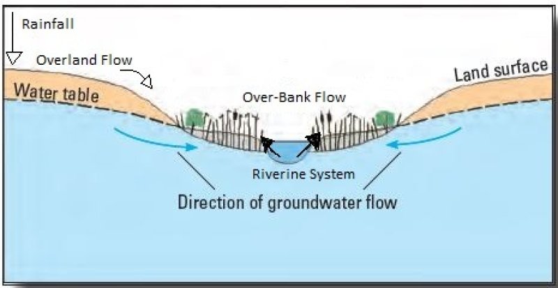
Floodplain marshes are frequently flooded wetland communities occurring within river floodplains dominated by herbaceous vegetation. Trees are sparse to absent. Flat topography and slow drainage create prolonged inundation periods caused by flooding conditions of adjacent rivers and streams, as well as inputs from overland flow and rainfall.
This community correlates with the Florida Natural Area Inventory community "Floodplain Marsh" (FNAI, 2010).
Forest overstory. Occasional cabbage palm (Sabal palmetto) and other flood tolerant trees may be widely scattered in these systems, and will often increase in density along the ecotones of upland communities.
Forest understory. Sand cordgrass (Spartina bakeri), sawgrass (Cladium jamaicense), and maidencane (Panicum hemitomon) are common dominants, but various other herbs may be found distributed along a hydrologic gradient.
Broadleaf emergents and floating plants, particularly bulltongue arrowhead (Sagittaria lancifolia), bladderworts (Utricularia spp.), pickerelweed (Pontederia cordata), yellow pondlily (Nuphar advena) occupy the deepest, most frequently flooded sites, and mixed herbaceous stands are found in the somewhat higher portions of the marsh.
The highest part of the marsh is often a drier, wet prairie-like zone with a large diversity of graminoids and forbs. Additional herbs can include dotted smartweed (Polygonum punctatum), bulrushes (Scirpus spp.), common reed (Phragmites australis), tickseeds (Coreopsis spp.), primrosewillows (Ludwigia spp.), fimbries (Fimbristylis spp.), spikerushes (Eleocharis spp.), flatsedges (Cyperus spp.), many flower marshpennywort (Hydrocotyle umbellata), soft rush (Juncus effusus ssp. solutus), grassleaf rush (Juncus marginatus), beaksedges (Rhynchospora spp.), rosy camphorweed (Pluchea rosea), lemon bacopa (Bacopa caroliniana), spadeleaf (Centella asiatica), swamp rosemallow (Hibiscus grandiflorus), saltmarsh morning glory (Ipomoea sagittata), cattails (Typha spp.), southern cutgrass (Leersia hexandra), and climbing hempvine (Mikania scandens).
Dominant plant species
-
sand cordgrass (Spartina bakeri), grass
-
Jamaica swamp sawgrass (Cladium mariscus ssp. jamaicense), grass
-
maidencane (Panicum hemitomon), grass
-
beaksedge (Rhynchospora), grass
-
bulltongue arrowhead (Sagittaria lancifolia), other herbaceous
-
bladderwort (Utricularia), other herbaceous
-
pickerelweed (Pontederia cordata), other herbaceous
-
common reed (Phragmites australis), other herbaceous
-
cattail (Typha), other herbaceous
-
grassleaf rush (Juncus marginatus), other herbaceous
Community 1.2
Shrub - Scrub Wetland
These wetlands are the result of the drawdown of the water table of a non-forested wetland that no longer reflects it natural hydroperiod. Deposition of seeds from aerial dispersion from birds or from flood pulses will provide the system with viable variable seedbank. These shrubs will consist of both true shrubs that never attain a greater height, and young trees of other species that may never obtain their maximum height due to the harsh environmental conditions. There will be no plants in the overstory, with a midcanopy of shrubs and young trees, and a dense to sparse understory of grasses and herbaceous species typical of the reference community it transitioned from.
Forest understory. Woody shrubs will be low-growing and densely packed, shading out the reference community understory species. These trees and shrubs will be less than 20 feet (6 meters) in height. Common species which will encroach and become established include wax myrtle (Morella cerifera), coastal plain willow (Salix caroliniana), cypress (Taxodium), common buttonbush (Cephalanthus occidentalis), fetterbush (Lyonia lucida), and cabbage palm (Sabal palmetto). Sparse reference community understory grasses and sedges may be present.
Pathway 1.1a
Community 1.1 to 1.2
This transition is driven by decreases in the long term hydroperiod. This change of hydrology will allow for the growth and establishment of woody species that would not have been able to colonize due to the flooding conditions.
Pathway 1.2a
Community 1.2 to 1.1
This transition is driven by the removal of undesirable species and reestablishment of natural management strategies. Removal of undesirable hardwood species may be necessary to increase light availability to herbaceous groundcover and should be removed carefully to prevent disturbance to the surrounding community. Restoration and reestablishment of natural management strategies should include restoring the seasonal high-water table and flooding conditions of the reference community. Introduction or reintroduction of fire into the system may serve to supplement the effects flooding conditions would have on the reference community.
State 2
Forested Wetlands
This state is described as wetlands dominated by trees and are often called swamp communities. The most common trees found in forested wetlands are cypress and tupelo, as well as several hardwoods such as bays, gums, elms, oaks, titi, and maples. Individual community composition and structure is dependent on patterns of seasonal flooding and small differences in microtopography. Arboreal epiphytes are abundant in forested wetlands and can be found growing on tree trunks and limbs, obtaining moisture and nutrients from condensation and rainfall. Buttressed trunks and modified root systems such as cypress knees are adaptations to prolonged hydroperiods and are characteristic of these communities, and may often create micro-habitats supporting species less adapted to prolong hydroperiods. Mosses and lichens growing on the bark of these species will serve as an indicator to seasonal inundation levels by growing to the water line.
Community 2.1
Cypress- Tupelo Floodplain Swamp
This community describes a forested wetland that is a closed canopy forest of hydrophytic trees dominated by a stand of cypress or tupelo. These will often occur on frequently flooded hydric sandy soils adjacent to stream and river channels and on oxbows. These will range in size from narrow strips along primary and secondary streams to expansive stands along large rivers.
This community correlates to the Florida Natural Area Inventory community "Floodplain Swamp" (FNAI, 2010).
Forest overstory. The canopy is sometimes a pure stand of bald cypress (Taxodium distichum), but more commonly bald cypress shares dominance with one or more of the following tupelo species: water tupelo (Nyssa aquatica) or swamp tupelo (N. sylvatica var. biflora). Other canopy trees capable of withstanding frequent inundation may be present but rarely dominant, including water hickory (Carya aquatica), overcup oak (Quercus lyrata), red maple (Acer rubrum), green ash (Fraxinus pennsylvanica), American elm (Ulmus americana), and swamp laurel oak (Q. laurifolia). Pond cypress (T. ascendens) is sometimes present in backswamps and depressions of the more hydrologically isolated areas of the floodplain. Arboreal epiphytes such as airplants (Tillsandia spp.), and mosses and lichens will be present on trunks and limbs of overstory trees to the upper limit of the water lines present on the trees.
Forest understory. Shrubs and smaller trees such as Carolina ash (Fraxinus caroliniana), planer tree (Planera aquatica), black willow (Salix nigra), titi (Cyrilla racemiflora), Virginia willow (Itea virginica), common buttonbush (Cephalanthus occidentalis), cabbage palm (Sabal palmetto), and dahoon (Ilex cassine) may be present.
A groundcover of flood tolerant ferns, grasses, and herbs are found in some floodplain swamps primarily dominant during the dry season when there is little to no surface water. During the wet season when these areas are flooded this site may support floating aquatic and subaqueous freshwater vegetation. Herbaceous species include lizard’s tail (Saururus cernuus), false nettle (Boehmeria cylindrica), creeping primrosewillow (Ludwigia repens), savannah panicum (Phanopyrum gymnocarpon), royal fern (Osmunda regalis var. spectabilis), dotted smartweed (Polygonum punctatum), climbing aster (Symphyotrichum carolinianum), and string lily (Crinum americanum). Grasses may include maidencane (Panicum hemitomon), blue maidencane (Amphicarpum muehlenbergianum) and sawgrass (Cladium mariscus ssp. jamaicense). These species tend to decrease in cover during the wet season and become replaced with surface water which may support a mixture of floating aquatics such as duckweeds (Lemna spp.) and Florida mudmidget (Wolffiella gladiata).
Dominant plant species
-
bald cypress (Taxodium distichum), tree
-
pond cypress (Taxodium ascendens), tree
-
water tupelo (Nyssa aquatica), tree
-
swamp tupelo (Nyssa biflora), tree
-
Ogeechee tupelo (Nyssa ogeche), tree
-
coastal plain willow (Salix caroliniana), shrub
-
Carolina ash (Fraxinus caroliniana), shrub
-
wax myrtle (Morella cerifera), shrub
-
Virginia sweetspire (Itea virginica), shrub
-
dahoon (Ilex cassine), shrub
-
maidencane (Panicum hemitomon), grass
-
Muhlenberg maidencane (Amphicarpum muehlenbergianum), grass
-
Jamaica swamp sawgrass (Cladium mariscus ssp. jamaicense), grass
-
royal fern (Osmunda regalis var. spectabilis), other herbaceous
-
toothed midsorus fern (Blechnum serrulatum), other herbaceous
-
airplant (Tillandsia), other herbaceous
-
creeping primrose-willow (Ludwigia repens), other herbaceous
-
climbing aster (Ampelaster carolinianus), other herbaceous
Community 2.2
Mixed Hardwoods Floodplain Swamp
This community consists of a closed overstory of cypress-tupelo and hardwood species such as bays, gums, elms, oaks, titi, and maple. Mixed hardwood swamps rely on the absence of fire for very long periods of time to allow for the accumulation of surficial organic matter which will raise the ground surface, decreasing the amount of standing water present with less water-level fluctuation. This community can often be identified by a higher density of these hardwood species in the overstory and increased peat accumulation. It may be common to see high seedling densities of these hardwood species, particularly bays, and may have an increased density of sphagnum moss beds due to high soil saturation but less frequent inundation. These communities are often relatively small in size, and may be seen as isolated hummocks within a cypress swamp community. Under a natural disturbance regime in the reference communities, successional change is thought to be rare since these swamps become seasonally dry and would burn periodically, killing these hardwoods and preventing organic matter build up. Increases in anthropogenic activity in surrounding areas by drainage or protection from fire may speed up these processes. This community may be a result of logging influences on natural cypress swamps, as increased light availability and logging slash may provide suitable habitat for the growth of these hardwoods as well as the natural regeneration of cypress.
Dominant plant species
-
bald cypress (Taxodium distichum), tree
-
water tupelo (Nyssa aquatica), tree
-
pond cypress (Taxodium ascendens), tree
-
swamp tupelo (Nyssa biflora), tree
-
Ogeechee tupelo (Nyssa ogeche), tree
-
water hickory (Carya aquatica), tree
-
overcup oak (Quercus lyrata), tree
-
red maple (Acer rubrum), tree
-
green ash (Fraxinus pennsylvanica), tree
-
American elm (Ulmus americana), tree
-
laurel oak (Quercus laurifolia), tree
Pathway 2.1a
Community 2.1 to 2.2
This transition is driven by decreases in the long term hydroperiod. This change of hydrology will allow for the growth and establishment of woody species that would not have been able to colonize due to the flooding conditions.
State 3
Grazed Rangeland
Rangelands are described as lands on which the indigenous vegetation is predominately grasses, grass-like plants, forbs, and possibly shrubs or dispersed trees. Existing plant communities can include both native and introduced plants. Primary export from Florida ranges are cattle and have been present in the state since their first introduction by Spanish explorers in 1521. Native forage production is very good with proper management in this community, with only a slight effect on the community. Proper management will often result in an increase of grasses and reduction of shrubs while also maintaining proper fire intervals. Rangelands provide a diversity of ecosystems and also provide a diverse and significant production of economic benefits and ecosystem goods and services. Livestock production along with sustainable wildlife populations provide for the major direct economic benefits, but also tourism, recreational uses, minerals/energy production, renewable energy, and other natural resource uses can be very significant. Vital ecosystem contributions include clean water, clean air, fish/wildlife habitat, as well as intangible considerations such as historical, cultural, aesthetic and spiritual values. It is strongly advised that consultation with State Resource Conservationist and District Conservationists at local NRCS Service Centers be sought when assistance is needed in developing management recommendations or prescribed grazing practices.
Rangeland in this ecological site is described for the Non-Forested Wetland state, not for the Forested Wetland state. Non-Forested Wetland communities have higher percentages of forgeable species due to the natural community composition and structure and have commonly been used as rangeland since European settlement. Forested Wetlands may have some forgeable species in the understory but are not utilized as rangeland. The major limitation to grazing species in these communities are extended hydroperiods represented by flooded conditions.
Community 3.1
Maidencane – Cutgrass- Toothache Grass – Blue Maidencane (RSG010 - Excellent)
This phase represents the representative phase of the natural community that has been converted to rangeland in excellent conditions. This phase will have an open canopy with an open or shrubby understory dependent on the reference state. In excellent condition maidencane (Panicum hemitomon), cutgrass (Zizaniopsis miliacea), toothache grass (Ctenium floridanum), and blue maidencane (Amphicarpum muhlenbergianum) species will provide the greatest portion of the forage production. These wetlands are often grazed in the winter months when there is little to no standing water in these communities and forage species will provide the greatest nutritional values. This community correlates with the Florida Legacy Range Site 155XY010FL – “Freshwater Marshes and Ponds”.
Resilience management. Proper range management of rotational grazing, burning, and hydrologic management may improve the condition of a range. Rotation of cattle on range is important mostly for the maintenance of the range resource to ensure areas are not overgrazed and ecological integrity is protected.
Rotational burning is the oldest and perhaps the least expensive method to improve forage quality. The practice consists of burning different portions of the range at different times during the fall and winter and permitting cows to move to new burns. Burning should be consistent with natural fire return intervals of the community being grazed to prevent a shift in species composition. Burning and grazing can lead to range deterioration if not used properly. Forages must be allowed to regrow (no grazing) to restore vigor, and when cattle are allowed to graze regrowth, care must be taken to assure that these burned areas are not overgrazed, especially in May and June. Prescribed fire for range improvement will also benefit undesirable shrub control and improve wildlife habitat as well as hazardous fuel reduction.
Rotation is essential to prevent overgrazing from cattle species in these freshwater marshes and prairies. Marshes that are subject to extensive grazing and cattle trampling will create open spaces devoid of native vegetation, changing competitive dynamics between plant species leading to shifts in wetland plant communities. These areas are highly susceptible to invasion of weedy pasture grasses, especially where the surround community has been converted to pasture, with the wetland left as wildlife habitat and watering holes. Invasive pasture grasses may include carpet grass, centipede grass, bahiagrass, and the invasive West Indian Marsh Grass.
One of the greatest limiting factors to grazing in these communities is the seasonal high-water tables, which may result in varying depths of ponding conditions during the summer months. Drainage or drawdown of the water table of these communities may lead to shifts in species composition and should be carefully managed.
Community 3.2
Typha spp – Pickerelweed – Torpedo grass- Threeawns (RSG010 – Poor to Fair)
This phase represents the transition of rangeland in excellent condition to poor or fair conditions. Duration of this phase is dependent on former and future management, use, and impacts. This poor to fair condition phase will most often consist of cattail species (Typha spp), pickerelweed (Pontederia cordata), torpedo grass (Panicum repens) and a variety of threeawns (Aristida spp.). This phase often transitions due to poor management, including overstocking and overgrazing, as well as mismanagement of the natural habitat. Other undesirable species may be present in this community that have not been mentioned,
Pathway 3.1a
Community 3.1 to 3.2
This pathway occurs when range management activities include overgrazing, overstocking, etc., natural succession of the once managed site leads to this stage.
Pathway 3.2a
Community 3.2 to 3.1
This pathway represents renovation of the unmanaged condition back to managed rangeland in excellent condition. Management activities likely include mechanical removal of the larger, woody vegetation followed by herbicide treatment and establishment of desired seeding mixtures, and correcting grazing management plans.
State 4
Managed Grassland / Pastureland
Pasture is a land use type having vegetation cover comprised primarily of introduced or enhanced native forage species that is used for livestock grazing. Pasture vegetation can consist of grasses, legumes, other forbs, shrubs or a mixture. The majority of these forages are introduced, having originally come from areas in other states or continents. Most are now naturalized and are vital components of pasture based grazing systems. Pasture lands provide many benefits other than forage for livestock. Wildlife use pasture as shelter and for food sources. Well managed pasture captures rainwater that is slowly infiltrated into the soil which helps recharge groundwater. Many small pasture livestock operations are near urban areas providing vistas for everyone to enjoy. It is especially important as livestock managers continues to experience extraordinarily high fuel and other input costs. Overgrazed pastures can lead to soil compaction and numerous bare spots, which may then become focal points of accelerated erosion and colonization sites of undesirable plants or weeds. It is strongly advised that consultation with State Resource Conservationist and District Conservationists at local NRCS Service Centers be sought when assistance is needed in developing management recommendations or prescribed grazing practices. This grassland / pastureland state correlates with the 2013 Florida Forage Suitability Group G155XB145FL (Sandy Soils on Stream Terraces, Flood Plains, or in Depressions). If the reference communities are drained and then converted to grasslands or pasture, then forage species and values correlating with the 2013 Forage Suitability Group G155XY141FL (Sandy Soils, on Flats on Mesic or Hydric Lowlands) should be utilized.
Community 4.1
Limpograss – Maidencane – Blue Maidencane (FSG 145)
This community phase represent commonly planted forage species on pasturelands, haylands, and open grasslands found adaptive to the natural seasonal high-water table representative of this community. The suite of plants established on any given site may vary considerably depending upon purpose, management goals, and usage (e.g., horses vs. cattle). Most systems include a mixture of grasses and legumes that provide forage throughout the growing season. Warm season perennial forage species often include limpograss (Hemarthria altissima), maidencane (Panicum hemitomon), and blue maidencane (Amphicarpum muhlenbergianum). Warm season annual forage species often include Japanese millet (Echinochloa esculenta) and aeschynomene (Aeschynomene americana). Several additional plants and/or species combinations may be present depending on the objectives and management approaches of the land manager/owner.
Resilience management. These species are dependent on a high-water table, if the area is excessively drained, these soils may support a more diverse set of forage species and management practices seen in community 4.2.
Community 4.2
Bahiagrass – Bermudagrass – Bluestem (FSG 141)
This community phase represent commonly planted forage species on pasturelands, haylands, and open grasslands found in drained and cultivated areas of this natural community. The suite of plants established on any given site may vary considerably depending upon purpose, management goals, and usage (e.g., horses vs. cattle). Most systems include a mixture of grasses and legumes that provide forage throughout the growing season. Warm season perennial forage species often include bahiagrass (Paspalum notatum), bermudagrass (Cynodon dactylon), stargrass (Cynodon nlemfuensis), limpograss (Hemarthria altissima), big bluestem (Andropogon gerardii), purple bluestem (Andropogon glomeratus var. glaucopsis), yellow indiangrass (Sorghastrum nutans), lopsided indiangrass (Sorghastrum secundum), switchgrass (Panicum virgatum), rhizoma perennial peanut (Arachis glabrata), and carpon desmodium (Desmodium heterocarpon).Warm season annual forage species often include browntop millet (Urochloa ramosa), pearl millet (Pennisetum glaucum), sorghum (Sorghum bicolor), hairy indigo (Indigofera hirsuta), and aeschynomene (Aeschynomene americana). Cool season annual forage species often include annual ryegrass (Lolium perenne ssp. multiflorum), oat (Avena sativa), rye (Secale cereale), wheat (Triticum aestivum), white clover (Trifolium repens) and Triticale (x Triticosecale rimpaui). Several additional plants and/or species combinations maybe present depending on the objectives and management approaches of the land manager/owner.
Resilience management. Surface and subsurface texture is predominantly fine sand or sandy soils with moderate water holding capacity, and a seasonal high-water table ranging from 0 - 1 feet during wet periods. Soils are generally flat with a slope no greater than 2%, with very brief ponding following large seasonal rainfall events on some soils in this series. The ponding usually lasts less than 14 days with minimum to no negative impacts on production of adapted forage species. Irrigation and drainage is commonly used for crop production on these soils and can be found on old abandoned crop land converted to improved pastures; however, increases in forage yield related to drainage and irrigation are not well documented for these soils. Total production of all forage species is expected to be higher than other groups due to increased available water during the growing season.
Use of cool season forages such as annual ryegrass, oats, and wheat planted in a prepared seedbed is dependent upon the location in the MLRA. Forage production is usually at the middle to lower end of the production range due to limited and sporadic rainfall during fall and winter months, particularly in the southern half of this MLRA. Additionally in the southern portion of the MLRA, warm temperatures persisting into the fall and returning quickly in the spring greatly shorten the production period for cool season forages. Thus, in the southern portion of the MLRA, cool season forages generally will only produce sufficient winter grazing in years with average and above average rainfall (El Niño winters) for specialized management uses such as creep grazing, early weaning, or purebred operations. While in more northerly locations in the MLRA, planting winter annual forages for use as a winter feed supply for the whole cow herd may be practical most years due to better winter rainfall. Overseeding annual ryegrass on a bahiagrass pasture also is not recommended in the southern end of this MLRA, due to excessive competition from bahiagrass for soil moisture, but may be an option in the northern portions of the MLRA.
Similarly winter legumes are less productive the further south in the MLRA the site is located. White clover is the only winter legume recommended for these sites due to its better tolerance to saturated soil conditions. Grazing management and fertilization need to favor the legume component for persistence. Even then, reseeding every other year may be necessary. White clover ,which is normally considered a perennial species, functions more as an annual in Florida and thus is heavily dependent upon reseeding to persist. Due to bloat issue, white clover should be used only in mixtures unless bloat preventative treatments are fed.
Initial growth of perennial warm season grasses and legumes or establishment of warm season annual grasses may be delayed in the spring due to low rainfall. Often production of perennial species also dips during the April/May dry period. Once normal summer rainfall begins, plant production should resume. Warm season legumes such as aeschynomene and carpon desmodiumcan also be oversown onto warm season grasses in this forage suitability group, although fertilization (no N fertilizer) and grazing management needs to favor legume establishment and persistence. Additional lime may be needed to maintain a pH of 5.5 to 6.0. Improved grass varieties such as stargrass and limpograss may also be grown on these soils although stargrass is generally limited to the part of the MLRA south of the US I-4 corridor. Limpograss should be limited to soils where drainage has not been altered.
Dominant plant species
-
bahiagrass (Paspalum notatum), grass
-
Bermudagrass (Cynodon dactylon), grass
-
African Bermudagrass (Cynodon nlemfuensis), grass
-
limpograss (Hemarthria altissima), grass
-
big bluestem (Andropogon gerardii), grass
-
purple bluestem (Andropogon glaucopsis), grass
-
Indiangrass (Sorghastrum nutans), grass
-
lopsided Indiangrass (Sorghastrum secundum), grass
-
switchgrass (Panicum virgatum), grass
-
pearl millet (Pennisetum glaucum), grass
-
browntop millet (Urochloa ramosa), grass
-
sorghum (Sorghum bicolor), grass
-
Italian ryegrass (Lolium perenne ssp. multiflorum), grass
-
common oat (Avena sativa), grass
-
cereal rye (Secale cereale), grass
-
common wheat (Triticum aestivum), grass
-
rhizoma peanut (Arachis glabrata), other herbaceous
-
carpon desmodium (Desmodium heterocarpon var. heterocarpon), other herbaceous
-
hairy indigo (Indigofera hirsuta), other herbaceous
-
shyleaf (Aeschynomene americana), other herbaceous
-
white clover (Trifolium repens), other herbaceous
-
triticale (Triticosecale rimpaui), other herbaceous
Community 4.3
Dogfennel – Bunchgrass– Wax Myrtle (Unmanaged)
This phase represent the succession of pastureland and/or open grassland to unmanaged conditions. Duration of this phase is dependent on former and future management, use, and impacts. The early pioneer shrub thicket phase will be dependent on the available seedbank present. This unmanaged phase will most often consist of the shrub wax myrtle (Morella cerifera) and dogfennel (Eupatorium capillifolium), an aggressive native perennial that is characteristic of unimproved, unmanaged, or overgrazed pastures, where it adds the decline of forage yield and quality. Pasture grass present will enter a reproductive phase and have woody stems that are undesirable forage species. Other undesirable species may be present in this community that have not been mentioned,
Pathway 4.1a
Community 4.1 to 4.2
This pathway occurs when the natural grassland / pasture has been drained and the seasonal high-water table has been lowered, allowing for a greater variety of forage grasses.
Pathway 4.1b
Community 4.1 to 4.3
This pathway occurs when pasture management activities include overgrazing, overstocking, etc., natural succession of the once managed site leads to this stage.
Pathway 4.2a
Community 4.2 to 4.3
This pathway occurs when pasture management activities include overgrazing, overstocking, etc., natural succession of the once managed site leads to this stage.
Pathway 4.3a
Community 4.3 to 4.1
This pathway represents renovation of the unmanaged condition back to managed grassland / pasture in excellent condition. Management activities likely include mechanical removal of the larger, woody vegetation followed by herbicide treatment and establishment of desired seeding mixtures, and correcting grazing management plans.
Pathway 4.3b
Community 4.3 to 4.2
This pathway represents renovation of the unmanaged condition back to managed grassland / pasture in excellent condition. Management activities likely include mechanical removal of the larger, woody vegetation followed by herbicide treatment and establishment of desired seeding mixtures, and correcting grazing management plans.
State 5
Silviculture
This state is important and used by silviculturists, landowners, land managers, and the public/private industry. Silviculture is land used in controlling the establishment, growth, composition, health, and quality of forests and woodlands to meet the diverse needs and values of landowners and society such as wildlife habitat, timber, water resources, restoration, and recreation on a sustainable basis. These are forestry practices that include thinning, harvesting, planting, pruning, prescribed burning and site preparation, for managed goals such as wildlife habitat creation or harvesting.
Because of the generally wet soil conditions associated with forested wetlands, some of these areas can be very sensitive to forestry activities, particularly during flooded or periods of soil saturation. For silviculture operations in general, wetlands are probably most susceptible to changes hydroperiod, which can result from improper forest road construction, logging operations, and certain types of site preparation activities. Due to management concerns within these wetlands, the creation and planting of tree plantations is not recommended and should be managed for stand harvesting and regeneration All silviculture operations should follow state and federal best management practices (BMP) to mitigate extensive damage to harvested wetlands.
These may include not significantly altering the natural drainage or flow patterns on forested lands, not conducting intensive mechanical site preparations such as bedding and fire line placement and avoiding road construction which may alter natural hydrologic flow. For harvesting in these wetlands, specific criteria is used to prevent excessive damage to the natural system. These may include retaining leave trees for wildlife habitat and seeding, removing logging slash from the wetland system, minimizing heavy equipment operations which may cause extensive rutting, and only operating and harvesting in dry seasons/ periods or using specialized equipment in wetter conditions. It is strongly advised that consultation with State Resource Conservationist and District Conservationists at local NRCS Service Centers be sought when assistance is needed in developing management recommendations for silviculture practices.
Resilience management. This state is managed by silviculture prescriptions that will vary based on individual forest stand and management goals.
Community 5.1
Cypress - Tupelo
This phase represents the prevailing composition and/or association of the species occurring on this site. In general, this wet site is not very productive and species richness is generally low. Because tree diversity is low, regeneration of cut stands may result in pure stands of cypress or tupelo or a mixed hardwood swamp consisting of cypress, bays, and maples. Additional complications arise from the difficulty of germination and seedling development due to excessively long hydroperiods. A dry cycle of several years may be the requirement for advancement of young seedlings in this environment. If the area is clear cut it may regenerate into a shrub – scrub wetland before transitioning into a forested wetland.
Dominant plant species
-
bald cypress (Taxodium), tree
-
tupelo (Nyssa), tree
State 6
Reclaimed / Restored Wetlands
The reclaimed/ restored wetland state consists of non-forested and forested wetland communities which have undergone or currently undergoing transition from an altered state (agriculture field, pasture, forestry land, urban areas) to a restored natural community. These reclaimed and restored natural communities will be managed to reflect the natural vegetation, management regimes, and hydroperiod of the reference community, with a history of land modification. This can often be accomplished through programs offered by the NRCS such as the Wetland Reserve Easements (WRE), a voluntary program to help restore and enhance wetlands which have been previously degraded due to agricultural uses. Restored wetlands will provide habitat to fish and wildlife, improve water quality by filtering sediments and chemicals, reduce flooding, recharge groundwater, protect biological diversity, and provide resilience to climate change. It is strongly advised that consultation with State Resource Conservationist and District Conservationists at local NRCS Service Centers be sought when assistance is needed in developing management recommendations for silviculture practices.
Community 6.1
Reclaimed / Restored Non-Forested Wetlands
This community described a reclaimed or restored non forested floodplain wetland community. Specific non-forested wetland community type will be dependent on local geomorphology, hydroperiods, fire regimes, and past management. While specific community type and species composition will depend on local factors, this community is unified through reclaimed or restored very poorly to poorly drained sandy soils which support non-forested wetlands on floodplains. Evidence of past management use (pasture/ agricultural uses) may be seen on the landscape. It may be common to see weedy or pasture forage species present in these areas along with native vegetation. These areas which have been converted back to non-forested wetlands are often under permanent or long-term (30 year) easement contracts. Restoration of a non-forested wetland is a long-term process to restore, protect, and enhance the restored wetland's function and values.
Community 6.2
Reclaimed / Restored Forested Wetlands
This community described a reclaimed or restored forested floodplain wetland community. Specific non-forested wetland community type will be dependent on local geomorphology, hydroperiods, fire regimes, and past management. While specific community type and species composition will depend on local factors, this community is unified through reclaimed or restored very poorly to poorly drained sandy soils which support forested wetlands on floodplains. Evidence of past management use (pasture/ agricultural uses) may be seen on the landscape. It may be common to see weedy or pasture forage species present in these areas along with native vegetation. These areas which have been converted back to non-forested wetlands are often under permanent or long-term (30 year) easement contracts. Restoration of a forested wetland is a long-term process to restore, protect, and enhance the restored wetland's function and values.
State 7
Invaded State
This state represents the dominance of one or multiple non-native or exotic species which outcompetes the native natural community and may significantly alter the composition and structure of the invaded stand by overshading the canopy and understory components and preventing regeneration of forest species.
Community 7.1
Melaleuca – Brazilian Peppertree – Torpedo Grass – Common Water Hyacinth
This phase describes the introduction and establishment of invasive species common to this ecological site; Brazilian peppertree (Schinus terebinthifolia), Torpedo grass (Panicum repens), water hyacinth (Eichhornia crassipes), and melaleuca (Melaleuca quinquenervia). These are fire tolerant shrubs (Brazilian peppertree), grasses (torpedo grass), and trees (Melaleuca) that will outcompete native plants of this ecological site. These species are adapted to the stressors created by extended hydroperiods and will often outcompete native species in both non-forested and forested wetlands.
Resilience management. Restoring native habitat may be very difficult with these species. Specific management plans may be required to identify and manage these species. It is strongly advised that consultation with State Resource Conservationist and District Conservationists at local NRCS Service Centers be sought when assistance is needed in developing management recommendations or invasive control practices.
State 8
Human Altered and Human Transported Soil Materials
These areas include soils that were intentionally and substantially modified by humans for an intended purpose, commonly for terraced agriculture, building support, mining, transportation, and commerce. The alteration is of sufficient magnitude to result in the introduction of a new parent material (human-transported material) or a profound change in the previously existing parent material (human-altered material). They do not include soils modified through standard agricultural practices or farmed soils with unintended wind and water erosion. When a soil is on or above an anthropogenic landform or microfeature, it can be definitely be associated with human activity and is assigned to a unique taxon, usually found as an "Urban land complex" within that communities' natural soil properties (e.g, Myakka fine sand-Urban land complex, frequently flooded, 0 to 2 percent slopes).
Characteristics and indicators. Evidence of these areas include soils with manufactured items (e.g. artifacts) present in the profile, human altered-materials (e.g., deeply excavated soil) or human-transported material (e.g., fill), and position on or above anthropogenic landforms (e.g., flood-control levees) and microfeatures (e.g., drainage ditches). Detailed criteria regarding the identification of anthropogenic (artificial) landforms, human-altered materials, and human-transported material are in the "Keys to Soil Taxonomy" (Soil Survey Staff, 2014).
Community 8.1
Urban
This urban community consists of development for human use. Urban areas include a variety of land uses, e.g., inner city or urban core, industrial and residential areas, cemeteries, parks, and other open spaces; the overall function which may benefit the quality of human life. These often form an urban soil mosaic, where the natural landscape has been fragmented into parcels with distinctive disturbance and management regimes and, as a result, distinctive characteristic soil properties.
Resilience management. Within this community there are three different levels of urbanization, based off population dynamics, residential density, and intensity of development. These are labeled as low-intensity, medium-intensity, and high-intensity urban areas, which can eventually be split apart into its own separate state. Low-intensity urban areas may consist of single dwelling homes with little impact on the surrounding community which still somewhat represents the natural community (e.g., represents natural landscape, hydrology, and vegetation) , other examples of this are urban parks, cemeteries, or campgrounds with little urban development. Medium-intensity urban areas consist of larger urban dwellings with some natural features but have been modified to meet urban needs (e.g., towns). High-intensity urban areas are areas of heavily modified areas with complete alterations of the natural landscape, hydrology, and vegetation to support a very large population, which once constructed is permanently altered (e.g., metropolis areas/ active mines).
Community 8.2
Canals
This community consists of the creation and channelization of anthropogenic waterways for water control use and floodwater protection. Primary purposes of these systems are to transport floodwaters and reduce flood damage to upland communities in the area. These will often be seen as straight channels of variable depths and width which will permanently hold standing water. These systems are often dug with heavy machinery through the natural floodplain community. Artificial impoundment areas will often be constructed along the banks of these areas to provide more water control during periods of heavy flow. In more naturalized areas, these created canals will grade directly into a marsh or swamp system with no impoundment system. These areas will often alter the hydrology of the floodplain communities, allowing for more shrubby species to become prevalent in these areas as the majority of water is directed out of the system. Within the canal system itself, the area is dominated by open water which may support floating aquatic species.
Community 8.3
Impoundment Areas
This community is often seen in conjunction with the creation and channelization of anthropogenic waterways as deposited spoil materials creating artificial impoundment areas. These areas will often be seen immediately adjacent to a natural floodplain system or an altered canal system. These are often called levees, dikes, or spoil areas. They will range in height, shape, and slope, but can often be identified as rises in the immediate area next to a flooded waterbody. They will often be dominated by invasive or weedy grasses and shrubs along the lower base of the impoundment where moisture is more readily available. The top of these areas will often consist of bare sand or sparse weedy species due to more xeric conditions. These will often be mapped as an individual HAHT soil map unit such as "arents", and will be composed primarily of sandy, with some shell, clay and limerock which is slightly alkaline by nature.
Transition T1A
State 1 to 2
This transition is driven by the introduction and establishment of cypress. This may occur if the area is seeded (anthropogenically or naturally) and the hydroperiod is short enough (as in extreme drought years) for cypress to germinate and become established before seasonal flooding occurs. This maybe seen as a mixed stand of hardwoods and cypress species in an even aged stand or a pure overstory of cypress with a shrubby understory. Trees will often be greater than 20 feet (6 meters) in height.
Transition T1B
State 1 to 3
This mechanism is driven by the introduction of livestock species to the natural system and implementing a planned grazing strategy. Use of a planned grazing strategy to balance animal forage demand with available forage resources. Timing, duration, and frequency of grazing are controlled and some type of grazing rotation is applied to allow for plant recovery following grazing. It is strongly advised that consultation with State Resource Conservationist and District Conservationists at local NRCS Service Centers be sought when assistance is needed in developing management recommendations or prescribed grazing practices.
Transition T1C
State 1 to 4
Actions required to convert native habitat to pasture or forage production include herbicide application, seedbed preparation, and the establishment of desired plants. Decisions to convert native land to pastureland on this site should be made carefully and continuously evaluated before, during, and after conversion activities. This site is extremely susceptible to soil compaction and erosion. The decision to proceed with this action may have occurred before the regulation of wetlands within the state of Florida. Conversion may still be allowed if the proper permits are gathered in accordance with local, state, and federal regulations.
Transition T1D
State 1 to 7
This transition represents proliferation and dominance of an invasive species. Soil mechanical disturbances can compound this effect and create suitable conditions for invasive species.
Transition T1E
State 1 to 8
This transition is driven by the alteration and/ or transportation of soil materials via anthropogenic means.
Transition T2A
State 2 to 1
This transition is driven by severe fire, usually occurring in periods of drought, or from anthropogenic decrease in the natural hydroperiod. If the roots were protected from fire, many species will rapidly re-sprout and form a shrub –scrub wetland. If the root systems were destroyed, these areas may be colonized by marsh grasses. Areas subject to removal of tree species via logging practices may be recolonized by a shrub – scrub wetland if not replanted and managed for its reference forested wetland community.
Transition T2B
State 2 to 4
Actions required to convert native habitat to pasture or forage production include herbicide application, seedbed preparation, and the establishment of desired plants. Decisions to convert native land to pastureland on this site should be made carefully and continuously evaluated before, during, and after conversion activities. This site is extremely susceptible to soil compaction and erosion. The decision to proceed with this action may have occurred before the regulation of wetlands within the state of Florida. Conversion may still be allowed if the proper permits are gathered in accordance with local, state, and federal regulations.
Transition T2C
State 2 to 5
This pathway consists of prescribed silvicultural activities specifically designed to meet stand compositional and production objectives. Decisions to convert native land to silviculture on this site should be made carefully and continuously evaluated before, during, and after conversion activities. This pathway consists of prescribed silvicultural activities specifically designed to meet stand compositional and production objectives. The decision to proceed with this action may have occurred before the regulation of wetlands within the state of Florida. Conversion may still be allowed if the proper permits are gathered in accordance with local, state, and federal regulations.
Transition T2D
State 2 to 7
This transition represents proliferation and dominance of an invasive species. Soil mechanical disturbances can compound this effect and create suitable conditions for invasive species.
Transition T2E
State 2 to 8
This transition is driven by the alteration and/ or transportation of soil materials via anthropogenic means.
Restoration pathway R3A
State 3 to 1
This transition is driven by the removal of domesticated grazing species from the system and reintroduction of natural management strategies.
Transition T3A
State 3 to 4
Actions required to convert rangeland to pasture or forage production include herbicide application, seedbed preparation, and the establishment of desired plants. Decisions to convert rangeland to pastureland on this site should be made carefully and continuously evaluated before, during, and after conversion activities. This site is extremely susceptible to soil compaction and erosion. The decision to proceed with this action may have occurred before the regulation of wetlands within the state of Florida. Conversion may still be allowed if the proper permits are gathered in accordance with local, state, and federal regulations.
Transition T3B
State 3 to 5
This pathway consists of prescribed silvicultural activities specifically designed to meet stand compositional and production objectives. Decisions to convert native land to silviculture on this site should be made carefully and continuously evaluated before, during, and after conversion activities. This pathway consists of prescribed silvicultural activities specifically designed to meet stand compositional and production objectives. The decision to proceed with this action may have occurred before the regulation of wetlands within the state of Florida. Conversion may still be allowed if the proper permits are gathered in accordance with local, state, and federal regulations.
Transition T3C
State 3 to 7
This transition represents proliferation and dominance of an invasive species. Soil mechanical disturbances can compound this effect and create suitable conditions for invasive species.
Transition T3D
State 3 to 8
This transition is driven by the alteration and/ or transportation of soil materials via anthropogenic means.
Transition T4A
State 4 to 5
This pathway consists of prescribed silvicultural activities specifically designed to meet stand compositional and production objectives. Decisions to convert native land to silviculture on this site should be made carefully and continuously evaluated before, during, and after conversion activities. This pathway consists of prescribed silvicultural activities specifically designed to meet stand compositional and production objectives. The decision to proceed with this action may have occurred before the regulation of wetlands within the state of Florida. Conversion may still be allowed if the proper permits are gathered in accordance with local, state, and federal regulations.
Restoration pathway R4A
State 4 to 6
This restoration is driven by the reclamation and restoration of wetland habitats from an altered state. This often requires the establishment of natural hydroperiods and water flow as well as the replanting and management of native plant species. Re-establishment of the natural management regimes such as fire intervals will be necessary. All land management practices for the altered state should be suspended.
Transition T4B
State 4 to 7
This transition represents proliferation and dominance of an invasive species. Soil mechanical disturbances can compound this effect and create suitable conditions for invasive species.
Transition T4C
State 4 to 8
This transition is driven by the alteration and/ or transportation of soil materials via anthropogenic means.
Restoration pathway R5A
State 5 to 6
This restoration is driven by the reclamation and restoration of wetland habitats from an altered state. This often requires the establishment of natural hydroperiods and water flow as well as the replanting and management of native plant species. Re-establishment of the natural management regimes such as fire intervals will be necessary. All land management practices for the altered state should be suspended.
Transition T5A
State 5 to 7
This transition represents proliferation and dominance of an invasive species. Soil mechanical disturbances can compound this effect and create suitable conditions for invasive species.
Restoration pathway R7A
State 7 to 1
The establishment of, or a return to, natural habitat conditions following a previous invasive / non-native / undesirable species infestation may be possible in some areas. Successful actions will require relentless efforts that include removal of the species via chemical or mechanical or biological means. In some extreme cases, restoration attempts could result in greater erosion and worsening of local conditions. Please consult with District and Soil Conservationists at local NRCS Field Offices for advice and guidance on land restoration attempts on invaded areas.
Restoration pathway R7B
State 7 to 2
The establishment of, or a return to, natural habitat conditions following a previous invasive / non-native / undesirable species infestation may be possible in some areas. Successful actions will require relentless efforts that include removal of the species via chemical or mechanical or biological means. In some extreme cases, restoration attempts could result in greater erosion and worsening of local conditions. Please consult with District and Soil Conservationists at local NRCS Field Offices for advice and guidance on land restoration attempts on invaded areas.
Restoration pathway R7C
State 7 to 3
The establishment of, or a return to, altered land use conditions following a previous invasive / non-native / undesirable species infestation may be possible in some areas. Successful actions will require relentless efforts that include removal of the species via chemical or mechanical or biological means. In some extreme cases, restoration attempts could result in greater erosion and worsening of local conditions. Please consult with District and Soil Conservationists at local NRCS Field Offices for advice and guidance on land restoration attempts on invaded areas.
Restoration pathway R7D
State 7 to 4
The establishment of, or a return to, altered land use conditions following a previous invasive / non-native / undesirable species infestation may be possible in some areas. Successful actions will require relentless efforts that include removal of the species via chemical or mechanical or biological means. In some extreme cases, restoration attempts could result in greater erosion and worsening of local conditions. Please consult with District and Soil Conservationists at local NRCS Field Offices for advice and guidance on land restoration attempts on invaded areas.
Restoration pathway R7E
State 7 to 5
The establishment of, or a return to, altered land use conditions following a previous invasive / non-native / undesirable species infestation may be possible in some areas. Successful actions will require relentless efforts that include removal of the species via chemical or mechanical or biological means. In some extreme cases, restoration attempts could result in greater erosion and worsening of local conditions. Please consult with District and Soil Conservationists at local NRCS Field Offices for advice and guidance on land restoration attempts on invaded areas.
Transition T7A
State 7 to 8
This transition is driven by the alteration and/ or transportation of soil materials via anthropogenic means.
Restoration pathway R8A
State 8 to 6
This restoration is driven by the reclamation and restoration of wetland habitats from an altered state. This often requires the establishment of natural hydroperiods and water flow as well as the replanting and management of native plant species. Re-establishment of the natural management regimes such as fire intervals will be necessary. All land management practices for the altered state should be suspended.