
Natural Resources
Conservation Service
Ecological site R023XY039NV
LOAMY SLOPE 10-14 P.Z.
Last updated: 4/10/2025
Accessed: 04/26/2025
General information
Provisional. A provisional ecological site description has undergone quality control and quality assurance review. It contains a working state and transition model and enough information to identify the ecological site.
Ecological site concept
Currently there is only a draft of the initial concept for this ecological site. The initial concept for this site places it within the Clayey Mesic Plateaus 8-14 PZ Wyoming Big Sagebrush and Thurber's Needlegrass Ecological Site Group. To view the General STM and other information available for this ESG please go to https://edit.jornada.nmsu.edu/catalogs/esg/023X/R023XY909OR
This site is dominated by bluebunch wheatgrass with Thurber’s needlegrass as a subdominant component. It occurs on steep sideslopes ranging from 15 to over 50%. The soils in this site are shallow to moderately deep and well drained. Surface soils are medium textured and usually more than ten inches thick to a fine textured subsoil. A mollic epipedon is typically present. There are usually high amounts of gravels, cobbles and stones on the surface. Some soils are modified with high volumes of rock fragments through the soil profile. Soils are neutral to moderately alkaline with soil reaction increasing with depth. Permeability is moderate and available water capacity is low to moderate. Runoff is medium to rapid and the potential for sheet and rill erosion is moderate but will vary with slope gradient. Production varies from 450 lb/ac to 1000 lb/ac, with 700 lb/ac in normal years. This site has a tree state (6.0).
Associated sites
R023XY006NV |
LOAMY 8-10 P.Z. |
---|---|
R023XY031NV |
CLAYPAN 10-14 P.Z. |
R023XY037NV |
CLAY SLOPE 8-12 P.Z. |
R023XY041NV |
LOAMY 12-14 P.Z. |
R023XY047NV |
GRAVELLY CLAY 8-10 P.Z. |
Similar sites
R023XY030NV |
SOUTH SLOPE 8-12 P.Z. ACSP12-PSSPS codominant |
---|---|
R023XY020NV |
LOAMY 10-12 P.Z. PSSPS-ACTH7 codominant; slopes less than 30% |
R023XY018NV |
STONY SOUTH SLOPE 12-16 P.Z. LECI4 major grass; more productive site ARTRV dominant shrub |
R023XY016NV |
SOUTH SLOPE 12-16 P.Z. more productive site ARTRV dominant shrub |
R023XY042NV |
GRANITIC SOUTH SLOPE 12-14 P.Z. granitic parent material; ARTRV dominant shrub |
R023XY064NV |
SOUTH SLOPE 16+ P.Z. BRMA4-PSSPS codominant; more productive site; ARTRV dominant shrub |
Table 1. Dominant plant species
Tree |
Not specified |
---|---|
Shrub |
(1) Artemisia tridentata ssp. wyomingensis |
Herbaceous |
(1) Pseudoroegneria spicata ssp. spicata |
Physiographic features
This site occurs on steep sideslopes of lower mountains, hills, and plateaus on all aspects. At lower elevations this site is restricted to northerly exposures. Slopes range from 4 to 75 percent, but slope gradients of 15 to 50 percent are most typical. Elevations are 4100 to 8000 feet.
Table 2. Representative physiographic features
Landforms |
(1)
Mountain
(2) Hill (3) Plateau |
---|---|
Elevation | 1,250 – 2,438 m |
Slope | 4 – 75% |
Aspect | N |
Climatic features
The climate associated with this site is semiarid and characterized by cool, moist winters and warm, dry summers. Average annual precipitation is 10 to 14 inches. Mean annual air temperature is 44 to 49 degrees F. The average growing season is about 90 to 110 days.
Nevada’s climate is predominantly arid, with large daily ranges of temperature, infrequent severe storms, heavy snowfall in the higher mountains, and great location variations with elevation. Three basic geographical factors largely influence Nevada’s climate: continentality, latitude, and elevation. Continentality is the most important factor. The strong continental effect is expressed in the form of both dryness and large temperature variations. Nevada lies on the eastern, lee side of the Sierra Nevada Range, a massive mountain barrier that markedly influences the climate of the State. The prevailing winds are from the west, and as the warm moist air from the Pacific Ocean ascend the western slopes of the Sierra Range, the air cools, condensation occurs and most of the moisture falls as precipitation. As the air descends the eastern slope, it is warmed by compression, and very little precipitation occurs. The effects of this mountain barrier are felt not only in the West but throughout the state, with the result that the lowlands of Nevada are largely desert or steppes. The temperature regime is also affected by the blocking of the inland-moving maritime air. Nevada sheltered from maritime winds, has a continental climate with well-developed seasons and the terrain responds quickly to changes in solar heating.
Nevada lies within the mid-latitude belt of prevailing westerly winds which occur most of the year. These winds bring frequent changes in weather during the late fall, winter and spring months, when most of the precipitation occurs. To the south of the mid-latitude westerlies, lies a zone of high pressure in subtropical latitudes, with a center over the Pacific Ocean. In the summer, this high-pressure belt shifts northward over the latitudes of Nevada, blocking storms from the ocean. The resulting weather is mostly clear and dry during the summer and early fall, with scattered thundershowers. The eastern portion of the state receives significant summer thunderstorms generated from monsoonal moisture pushed up from the Gulf of California, known as the North American monsoon. The monsoon system peaks in August and by October the monsoon high over the Western U.S. begins to weaken and the precipitation retreats southward towards the tropics (NOAA 2004).
Average annual precipitation is 16 to over 20 inches. Mean annual air temperature is 41 to 44 degrees F. The average growing season is about 50 to 70 days.
Mean annual precipitaion at the Bear Creek, Nevada SNOTEL station (170501020301) is 37.69 inches.
monthly mean precipitation is:
January 3.84; February 3.75; March 4.38; April 4.9;
May 3.99; June 2.82; July .95; August 1.66;
September 1.22; October 2.12;
November 3.67; December 4.38.
Table 3. Representative climatic features
Frost-free period (average) | 100 days |
---|---|
Freeze-free period (average) | |
Precipitation total (average) | 305 mm |
Figure 1. Monthly precipitation range
Figure 2. Monthly average minimum and maximum temperature
Figure 3. Annual precipitation pattern
Figure 4. Annual average temperature pattern
Influencing water features
There are mo influencing water features associated with this site.
Soil features
The soils associated with this site are shallow to moderately deep and well to somewhat excessively drained. Surface soils are medium textured and usually more than ten inches thick to a fine textured subsoil. A mollic epipedon is typically present. There are usually high amounts of gravels, cobbles and stones on the surface. Some soils are modified with high volumes of rock fragments through the soil profile. Soils are neutral to moderately alkaline with soil reaction increasing with depth. Permeability is slow to moderately rapid and available water capacity is very low to low. Runoff is high to very high and the potential for sheet and rill erosion is moderate but will vary with slope gradient. The soil series associated with this site include: Bucklake, Burrita, Corral, Eaglerock, Felcher, Glenbrook, Grawfels, Indiano, Ister, Longcreek, Noslo, Reywat, and Terea.
Table 4. Representative soil features
Surface texture |
(1) Gravelly loam (2) Very stony loam (3) Very stony sandy loam |
---|---|
Family particle size |
(1) Loamy |
Drainage class | Well drained to somewhat excessively drained |
Permeability class | Slow to moderately rapid |
Soil depth | 25 – 102 cm |
Surface fragment cover <=3" | 13 – 35% |
Surface fragment cover >3" | 6 – 44% |
Available water capacity (0-101.6cm) |
2.29 – 11.68 cm |
Calcium carbonate equivalent (0-101.6cm) |
0 – 5% |
Electrical conductivity (0-101.6cm) |
0 – 2 mmhos/cm |
Sodium adsorption ratio (0-101.6cm) |
0 |
Soil reaction (1:1 water) (0-101.6cm) |
6.1 – 8.4 |
Subsurface fragment volume <=3" (Depth not specified) |
10 – 44% |
Subsurface fragment volume >3" (Depth not specified) |
4 – 43% |
Ecological dynamics
Where management results in abusive grazing use by livestock and/or feral horses, bluebunch wheatgrass and Thurber's needlegrass decrease as Sandberg bluegrass, rabbitbrush and big sagebrush increase. Thistle and cheatgrass are species likely to invade this site. Where this site occurs adjacent to juniper woodland communities these trees readily invade the site.
Fire Ecology:
The fire return interval for Wyoming big sagebrush communities ranges from 10 to 70 years. Fire is the principal means of renewal for decadent stands of Wyoming big sagebrush.
Wyoming big sagebrush is killed by fire and establishes after fire from a seedbank; from seed produced by remnant plants that escaped fire; and from plants adjacent to the burn that seed in. Antelope bitterbrush is considered a weak sprouter and is often killed by summer or fall fire. Antelope bitterbrush in some areas may sprout after light-severity spring fire. High fuel consumptions increase antelope bitterbrush mortality and therefore favors seedling establishment. Burning bluebunch wheatgrass may remove most of the aboveground biomass but does not usually result in plant mortality. Bluebunch wheatgrass is generally favored by burning. Burning stimulates flowering and seed production. However, season of burning affects mortality. Thurber’s needlegrass is classified as moderately resistant, but depending on season of burn, phenology, and fire severity, this perennial bunchgrass is moderately to severely damaged by fire. Early season burning is more damaging to this needlegrass than late season burning. Basin wildrye is top-killed by fire. Older basin wildrye plants with large proportions of dead material within the perennial crown can be expected to show higher mortality due to fire than younger plants having little debris. Basin wildrye is generally tolerant of fire but may be damaged by early season fire combined with dry soil conditions.
State and transition model
More interactive model formats are also available.
View Interactive Models
Click on state and transition labels to scroll to the respective text
Ecosystem states
State 1 submodel, plant communities
State 1
Reference Plant Community
Community 1.1
Reference Plant Community
The reference plant community is dominated by bluebunch wheatgrass and Wyoming big sagebrush. Potential vegetative composition is about 70% grasses, 10% forbs and 20% shrubs. Approximate ground cover (basal and crown) is about 35 to 45 percent.
Figure 5. Annual production by plant type (representative values) or group (midpoint values)
Table 5. Annual production by plant type
Plant type | Low (kg/hectare) |
Representative value (kg/hectare) |
High (kg/hectare) |
---|---|---|---|
Grass/Grasslike | 353 | 549 | 785 |
Shrub/Vine | 81 | 126 | 179 |
Forb | 50 | 78 | 112 |
Tree | 20 | 31 | 45 |
Total | 504 | 784 | 1121 |
Additional community tables
Table 6. Community 1.1 plant community composition
Group | Common name | Symbol | Scientific name | Annual production (kg/hectare) | Foliar cover (%) | |
---|---|---|---|---|---|---|
Grass/Grasslike
|
||||||
1 | Primary Perennial Grasses | 447–769 | ||||
bluebunch wheatgrass | PSSPS | Pseudoroegneria spicata ssp. spicata | 314–471 | – | ||
Thurber's needlegrass | ACTH7 | Achnatherum thurberianum | 118–235 | – | ||
basin wildrye | LECI4 | Leymus cinereus | 16–63 | – | ||
2 | Secondary Perennial Grasses | 16–63 | ||||
Indian ricegrass | ACHY | Achnatherum hymenoides | 4–16 | – | ||
Webber needlegrass | ACWE3 | Achnatherum webberi | 4–16 | – | ||
squirreltail | ELEL5 | Elymus elymoides | 4–16 | – | ||
Idaho fescue | FEID | Festuca idahoensis | 4–16 | – | ||
needle and thread | HECO26 | Hesperostipa comata | 4–16 | – | ||
prairie Junegrass | KOMA | Koeleria macrantha | 4–16 | – | ||
bluegrass | POA | Poa | 4–16 | – | ||
Forb
|
||||||
3 | Perennial | 39–118 | ||||
arrowleaf balsamroot | BASA3 | Balsamorhiza sagittata | 4–24 | – | ||
tapertip hawksbeard | CRAC2 | Crepis acuminata | 4–24 | – | ||
buckwheat | ERIOG | Eriogonum | 4–24 | – | ||
Shrub/Vine
|
||||||
4 | Primary Shrubs | 119–235 | ||||
Wyoming big sagebrush | ARTRW8 | Artemisia tridentata ssp. wyomingensis | 118–196 | – | ||
antelope bitterbrush | PUTR2 | Purshia tridentata | 1–39 | – | ||
5 | Secondary Shrubs | 39–78 | ||||
mountain big sagebrush | ARTRV | Artemisia tridentata ssp. vaseyana | 8–24 | – | ||
yellow rabbitbrush | CHVI8 | Chrysothamnus viscidiflorus | 8–24 | – | ||
mormon tea | EPVI | Ephedra viridis | 8–24 | – | ||
spiny hopsage | GRSP | Grayia spinosa | 8–24 | – | ||
wild crab apple | PERA4 | Peraphyllum ramosissimum | 8–24 | – | ||
currant | RIBES | Ribes | 8–24 | – | ||
desert snowberry | SYLO | Symphoricarpos longiflorus | 8–24 | – | ||
Tree
|
||||||
6 | Evergreen | 9–31 | ||||
western juniper | JUOC | Juniperus occidentalis | 4–16 | – | ||
Utah juniper | JUOS | Juniperus osteosperma | 4–16 | – |
Interpretations
Animal community
Livestock Interpretation:
This site has limited value for livestock grazing due to steep slopes. Grazing management should be keyed to perennial grass production. Bluebunch wheatgrass is considered one of the most important forage grass species on western rangelands for livestock. Although bluebunch wheatgrass can be a crucial source of forage, it is not necessarily the most highly preferred species. Thurber’s needlegrass species begin growth early in the year and remain green throughout a relatively long growing season. This pattern of development enables animals to use Thurber’s needlegrass when many other grasses are unavailable. Cattle prefer Thurber’s needlegrass in early spring before fruits have developed as it becomes less palatable when mature. Thurber’s needlegrasses are grazed in the fall only if the fruits are softened by rain. The early growth and abundant production of basin wildrye make it a valuable source of forage for livestock. It is important forage for cattle and is readily grazed by cattle and horses in early spring and fall. Though coarse-textured during the winter, basin wildrye may be utilized more frequently by livestock and wildlife when snow has covered low shrubs and other grasses. Livestock browse Wyoming big sagebrush, but may use it only lightly when palatable herbaceous species are available. Antelope bitterbrush is important browse for livestock. Domestic livestock and mule deer may compete for antelope bitterbrush in late summer, fall, and/or winter. Cattle prefer antelope bitterbrush from mid-May through June and again in September and October.
Stocking rates vary over time depending upon season of use, climate variations, site, and previous and current management goals. A safe starting stocking rate is an estimated stocking rate that is fine tuned by the client by adaptive management through the year and from year to year.
Wildlife Interpretation:
Wyoming big sagebrush is preferred browse for wild ungulates. Pronghorn usually browse Wyoming big sagebrush heavily. Sagebrush-grassland communities provide critical sage-grouse breeding and nesting habitats. Meadows surrounded by sagebrush may be used as feeding and strutting grounds. Sagebrush is a crucial component of their diet year-round, and sage-grouse select sagebrush almost exclusively for cover. Sage-grouse prefer mountain big sagebrush and Wyoming big sagebrush communities to basin big sagebrush communities.
Pronghorn antelope, mule deer, elk, and bighorn sheep utilize antelope bitterbrush extensively. Mule deer use of antelope bitterbrush peaks in September, when antelope bitterbrush may compose 91 percent of the diet. Winter use is greatest during periods of deep snow. Antelope bitterbrush seed is a large part of the diets of rodents, especially deer mice and kangaroo rats. Bluebunch wheatgrass is considered one of the most important forage grass species on western rangelands for wildlife. Bluebunch wheatgrass does not generally provide sufficient cover for ungulates, however, mule deer are frequently found in bluebunch-dominated grasslands. Thurber needlegrass is valuable forage for wildlife. Basin wildrye provides winter forage for mule deer, though use is often low compared to other native grasses. Basin wildrye provides summer forage for black-tailed jackrabbits. Because basin wildrye remains green throughout early summer, it remains available for small mammal forage for longer time than other grasses.
Hydrological functions
Runoff is high to very high. Permeaiblity is slow to moderately rapid. Hydrologic soil group is C and D. Rills and pedestals are typically non-existent There may be a few rills (widely spaced and shallow) on steeper slopes (over 20% gradient). Frost heaving of shallow rooted plants should not be considered a "normal" condition. Water flow patterns are typically but can rarely occur on steeper slopes in areas recently subjected to intense summer convection storms or rapid snowmelt. Gullies are non-existent. Perennial herbaceous plants (especially deep-rooted bunchgrasses [i.e., bluebunch wheatgrass] slow runoff and increase infiltration. Shrub canopy and associated litter break raindrop impact and provide opportunity for snow catch and accumulation on site.
Recreational uses
Aesthetic value is derived from the diverse floral and faunal composition and the colorful flowering of wild flowers and shrubs during the spring and early summer. This site offers rewarding opportunities to photographers and for nature study. This site is used for hiking and has potential for upland and big game hunting.
Other products
Native Americans made tea from big sagebrush leaves. They used the tea as a tonic, an antiseptic, for treating colds, diarrhea, and sore eyes and as a rinse to ward off ticks. Big sagebrush seeds were eaten raw or made into meal. Basin wildrye was used as bedding for various Native American ceremonies, providing a cool place for dancers to stand.
Other information
Wyoming big sagebrush is used for stabilizing slopes and gullies and for restoring degraded wildlife habitat, rangelands, mine spoils and other disturbed sites. It is particularly recommended on dry upland sites where other shrubs are difficult to establish. Antelope bitterbrush has been used extensively in land reclamation. Antelope bitterbrush enhances succession by retaining soil and depositing organic material and in some habitats and with some ecotypes, by fixing nitrogen. Basin wildrye is useful in mine reclamation, fire rehabilitation and stabilizing disturbed areas. Its usefulness in range seeding, however, may be limited by initially weak stand establishment.
Supporting information
Type locality
Location 1: Washoe County, NV | |
---|---|
Township/Range/Section | T36N R24E S6 |
UTM zone | N |
UTM northing | 307210 |
UTM easting | 4546026 |
Latitude | 41° 2′ 33″ |
Longitude | 119° 17′ 37″ |
General legal description | SE1/4SE1/4 Approximately 3 miles south of Chicken Spring on west side (east-facing sideslope) of Leadville Canyon Road (north of Hualapai Valley), Washoe County, Nevada. This site also occurs in Humboldt County, Nevada. |
Other references
Fire Effects Information System (Online; http://www.fs.fed.us/database/feis/plants/).
USDA-NRCS Plants Database (Online; http://www.plants.usda.gov).
Great Basin Ecological Site Development Project: State and Transition Models for Major Land Resource Area 23, Nevada and portions of California (Online; https://naes.agnt.unr.edu/PMS/Pubs/2019-4060.pdf)
Contributors
DK/SW/GKB
T Stringham (UNR under contract with BLM)
Approval
Kendra Moseley, 4/10/2025
Rangeland health reference sheet
Interpreting Indicators of Rangeland Health is a qualitative assessment protocol used to determine ecosystem condition based on benchmark characteristics described in the Reference Sheet. A suite of 17 (or more) indicators are typically considered in an assessment. The ecological site(s) representative of an assessment location must be known prior to applying the protocol and must be verified based on soils and climate. Current plant community cannot be used to identify the ecological site.
Author(s)/participant(s) | BLAINE HALIDAY |
---|---|
Contact for lead author | State Range Management Specialist |
Date | 06/20/2006 |
Approved by | Kendra Moseley |
Approval date | |
Composition (Indicators 10 and 12) based on | Annual Production |
Indicators
-
Number and extent of rills:
Typically none. There may be a few rills (widely spaced and shallow) on steeper slopes (over 20% gradient). -
Presence of water flow patterns:
Water flow patterns are typically non-existent but can rarely occur on steeper slopes in areas recently subjected to intense summer convection storms or rapid snowmelt. Short (< 1 m) and stable. -
Number and height of erosional pedestals or terracettes:
Pedestals are typically non-existent. Frost heaving of shallow rooted plants should not be considered a "normal" condition. -
Bare ground from Ecological Site Description or other studies (rock, litter, lichen, moss, plant canopy are not bare ground):
Bare Ground 20-30% depending on amount of surface rock fragments -
Number of gullies and erosion associated with gullies:
None -
Extent of wind scoured, blowouts and/or depositional areas:
None -
Amount of litter movement (describe size and distance expected to travel):
Fine litter (foliage from grasses and annual & perennial forbs) expected to move distance of slope length during intense summer convection storms or rapid snowmelt events. Persistent litter (large woody material) will remain in place except during large rainfall events. -
Soil surface (top few mm) resistance to erosion (stability values are averages - most sites will show a range of values):
Soil stability values should be 3 to 6 on most soil textures found on this site. (To be field tested.) -
Soil surface structure and SOM content (include type of structure and A-horizon color and thickness):
Surface structure is typically subangular blocky or platy. Soil surface colors are dark or grayish brown and soils are typified by a mollic epipedon. Organic matter of the surface 2 to 4 inches is typically 1.25 to 3 percent dropping off quickly below. Organic matter content can be more or less depending on micro-topography. -
Effect of community phase composition (relative proportion of different functional groups) and spatial distribution on infiltration and runoff:
Perennial herbaceous plants (especially deep-rooted bunchgrasses [i.e., bluebunch wheatgrass] slow runoff and increase infiltration. Shrub canopy and associated litter break raindrop impact and provide opportunity for snow catch and accumulation on site. -
Presence and thickness of compaction layer (usually none; describe soil profile features which may be mistaken for compaction on this site):
Compacted layers are none. Subsoil argillic horizons are not to be interpreted as compacted layers. -
Functional/Structural Groups (list in order of descending dominance by above-ground annual-production or live foliar cover using symbols: >>, >, = to indicate much greater than, greater than, and equal to):
Dominant:
Deep-rooted, cool season, perennial bunchgrassesSub-dominant:
tall shrubs (Wyoming big sagebrush) > associated shrubs = deep-rooted, cool season, perennial forbs > fibrous, shallow-rooted, cool season, perennial and annual forbs = shallow-rooted, cool season, perennial grasses and grass-like plantsOther:
evergreen treesAdditional:
-
Amount of plant mortality and decadence (include which functional groups are expected to show mortality or decadence):
Dead branches within individual shrubs common and standing dead shrub canopy material may be as much as 25% of total woody canopy; some of the mature bunchgrasses (<10%) have dead centers. -
Average percent litter cover (%) and depth ( in):
Under canopy and between plant interspaces (30-45%) and litter depth is ± ¼ inch. -
Expected annual annual-production (this is TOTAL above-ground annual-production, not just forage annual-production):
For normal or average growing season (through June) ± 700 lbs/ac; Favorable years 1000 lb/ac and unfavorable years 450 lbs/ac. Spring moisture significantly affects total production -
Potential invasive (including noxious) species (native and non-native). List species which BOTH characterize degraded states and have the potential to become a dominant or co-dominant species on the ecological site if their future establishment and growth is not actively controlled by management interventions. Species that become dominant for only one to several years (e.g., short-term response to drought or wildfire) are not invasive plants. Note that unlike other indicators, we are describing what is NOT expected in the reference state for the ecological site:
Potential invaders include cheatgrass, annual mustards, knapweeds, medusahead, and thistles. Junipers are increasers on this site. -
Perennial plant reproductive capability:
All functional groups should reproduce in average (or normal) and above average growing season years
Print Options
Sections
Font
Other
The Ecosystem Dynamics Interpretive Tool is an information system framework developed by the USDA-ARS Jornada Experimental Range, USDA Natural Resources Conservation Service, and New Mexico State University.
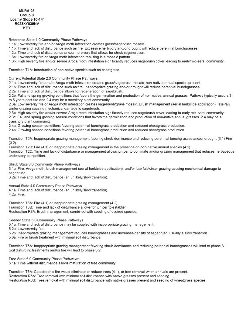
Click on box and path labels to scroll to the respective text.