Natural Resources
Conservation Service
Ecological site R024XY015NV
DEEP SODIC FAN
Last updated: 3/07/2025
Accessed: 04/10/2026
General information
Provisional. A provisional ecological site description has undergone quality control and quality assurance review. It contains a working state and transition model and enough information to identify the ecological site.
MLRA notes
Major Land Resource Area (MLRA): 024X–Humboldt Basin and Range Area
Major land resource area (MLRA) 24, the Humboldt Area, covers an area of approximately 8,115,200 acres (12,680 sq. mi.). It is found in the Great Basin Section of the Basin and Range Province of the Intermontane Plateaus. Elevations range from 3,950 to 5,900 feet (1,205 to 1,800 meters) in most of the area, some mountain peaks are more than 8,850 feet (2,700 meters).
A series of widely spaced north-south trending mountain ranges are separated by broad valleys filled with alluvium washed in from adjacent mountain ranges. Most valleys are drained by tributaries to the Humboldt River. However, playas occur in lower elevation valleys with closed drainage systems. Isolated ranges are dissected, uplifted fault-block mountains. Geology is comprised of Mesozoic and Paleozoic volcanic rock and marine and continental sediments. Occasional young andesite and basalt flows (6 to 17 million years old) occur at the margins of the mountains. Dominant soil orders include Aridisols, Entisols, Inceptisols and Mollisols. Soils of the area are generally characterized by a mesic soil temperature regime, an aridic soil moisture regime and mixed geology. They are generally well drained, loamy and very deep.
Approximately 75 percent of MLRA 24 is federally owned, the remainder is primarily used for farming, ranching and mining. Irrigated land makes up about 3 percent of the area; the majority of irrigation water is from surface water sources, such as the Humboldt River and Rye Patch Reservoir. Annual precipitation ranges from 6 to 12 inches (15 to 30 cm) for most of the area, but can be as much as 40 inches (101 cm) in the mountain ranges. The majority of annual precipitation occurs as snow in the winter. Rainfall occurs as high-intensity, convective thunderstorms in the spring and fall.
Ecological site concept
This ecological site is on alluvial flat and stream terraces. Soils are very deep, well drained, and formed in alluvium derived from mixed parent material. The soil profile is characterized by an ochric epipedon, a pH greater than 8.5 throughout and silt clay loam or loam texture.
Where this ecological site is correlated to poorly drained soil series should be evaluated as a CP of 024XY007NV, Saline Bottom.
Associated sites
| R024XY003NV |
SODIC TERRACE 6-8 P.Z. This ecological site is on lake plains and basin floor remnants. Soil is very deep, well drained and formed in a thin layer of loess and alluvium derived from mixed parent material influenced by volcanic ash over lacustrine sediments. Soils are characterized by a very low infiltration, an ochric epipedon, and moderate to very strong alkalinity. |
|---|---|
| R024XY004NV |
SILTY 4-8 P.Z. This ecological site is on fan piedmonts. Soils associated with this site are very deep, well drained and formed in alluvium derived from mixed rocks, loess and volcanic ash. The soil profile is characterized by an ochric epipedon, a sodium free surface, and moderately to strongly sodium effected subsoil. Soil textures are dominated by silt loam, ashy very fine silt loam, and/or ashy fine sandy loam. |
| R024XY007NV |
SALINE BOTTOM The soil profile is characterized by an ochric epipedon, strong to moderate salinity throughout and a high-water table between 70-100cm at some time during the year. Sodicity (SAR) is 13-99 in the upper 50cm and decreases with depth. Dominant plant species are Black greasewood (SAVE4) and Basin wildrye (LECI4) |
Similar sites
| R024XY011NV |
SODIC FLAT 6-8 P.Z. Important abiotic factors include crusting & baking of the surface layer upon drying, inhibiting water infiltration and seedling emergence. Greasewood (SAVE4) dominant shrub; Shadscale saltbrush (ATCO) minor shrub. |
|---|---|
| R024XY007NV |
SALINE BOTTOM Greasewood (SAVE4) dominant shrub; Torrey's saltbush (ATTO) minor shrub, if present. |
| R024XY006NV |
DRY FLOODPLAIN Soils are moderately well drained. Basin Big sagebrush (ARTRT) dominant shrub; Greasewood (SAVE4) minor shrub, or absent. |
| R024XY022NV |
SODIC TERRACE 8-10 P.Z. Soils are characterized by a very low infiltration, an ochric epipedon, moderate to very strong alkalinity. Greasewood (SAVE4), Big sagebrush (ARTR2) codominant; more productive site. |
Table 1. Dominant plant species
| Tree |
Not specified |
|---|---|
| Shrub |
(1) Atriplex torreyi |
| Herbaceous |
(1) Leymus cinereus |
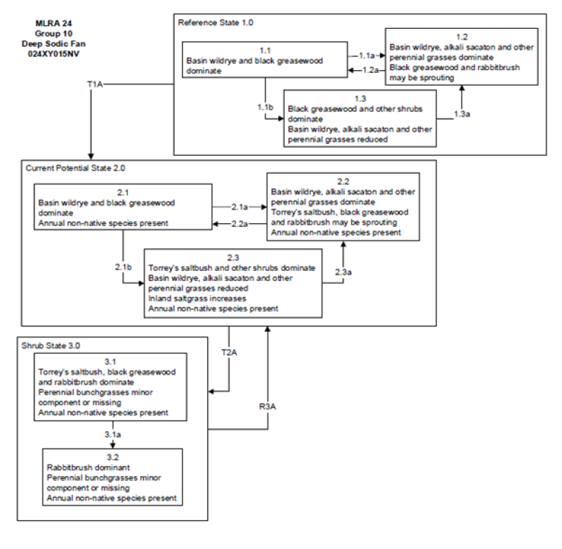
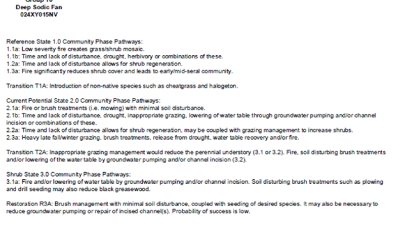
Click on box and path labels to scroll to the respective text.