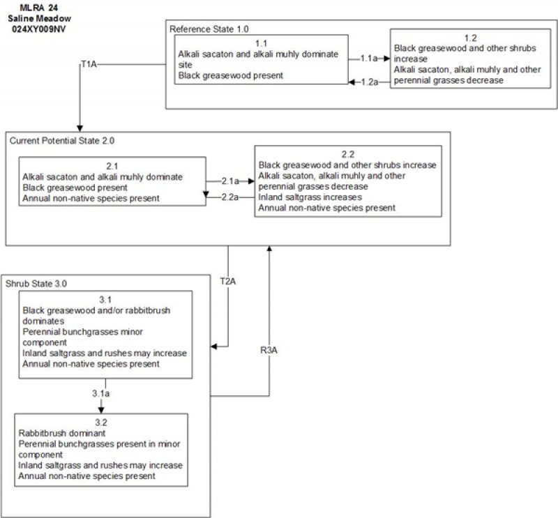
Provisional. A provisional ecological site description has undergone quality control and quality assurance review. It contains a working state and transition model and enough information to identify the ecological site.
MLRA notes
Major Land Resource Area (MLRA): 024X–Humboldt Basin and Range Area
Major land resource area (MLRA) 24, the Humboldt Area, covers an area of approximately 8,115,200 acres (12,680 sq. mi.). It is found in the Great Basin Section of the Basin and Range Province of the Intermontane Plateaus. Elevations range from 3,950 to 5,900 feet (1,205 to 1,800 meters) in most of the area, some mountain peaks are more than 8,850 feet (2,700 meters).
A series of widely spaced north-south trending mountain ranges are separated by broad valleys filled with alluvium washed in from adjacent mountain ranges. Most valleys are drained by tributaries to the Humboldt River. However, playas occur in lower elevation valleys with closed drainage systems. Isolated ranges are dissected, uplifted fault-block mountains. Geology is comprised of Mesozoic and Paleozoic volcanic rock and marine and continental sediments. Occasional young andesite and basalt flows (6 to 17 million years old) occur at the margins of the mountains. Dominant soil orders include Aridisols, Entisols, Inceptisols and Mollisols. Soils of the area are generally characterized by a mesic soil temperature regime, an aridic soil moisture regime and mixed geology. They are generally well drained, loamy and very deep.
Approximately 75 percent of MLRA 24 is federally owned, the remainder is primarily used for farming, ranching and mining. Irrigated land makes up about 3 percent of the area; the majority of irrigation water is from surface water sources, such as the Humboldt River and Rye Patch Reservoir. Annual precipitation ranges from 6 to 12 inches (15 to 30 cm) for most of the area, but can be as much as 40 inches (101 cm) in the mountain ranges. The majority of annual precipitation occurs as snow in the winter. Rainfall occurs as high-intensity, convective thunderstorms in the spring and fall.
Ecological site concept
This ecological site is on floodplains and inset fans. Soils are very deep, poorly drained and formed in alluvium derived from mixed parent material. The soil profile is characterized by a fine sand surface texture, an ochric epipedon, a pH of 8.2 at the surface increasing with depth, an SAR of >13 and a water table between 4-90cm.
Important abiotic factors contributing to this ecological site include high sodicity, moderately high salinity and a water near the surface at during some part of the year.
Based and soil characteristics, vegetative composition and abiotic factors this site does not differ from R024XY002OR, Sodic Meadow.
Saline Bottom ecological site is on alluvial flats, stream terraces and flood plains. Soils are very deep, somewhat poorly drained and formed in alluvium derived from mixed alluvium, loess and volcanic ash.
This ecological site is on alluvial flats. Soils are deep, poorly to somewhat poorly drained, and formed in alluvium derived from mixed rocks with a component of volcanic ash
This ecological site is on alluvial flats, soils are deep, poorly to somewhat poorly drained, and the soil profile is characterized by an ochric epipedon.
This site is on nearly level floodplains and alluvial flats. Slopes range from 0 to 2 percent but are mostly less than 2 percent. Elevations are 4000 to 5900 feet (1219 to 1798 m)
Table 2. Representative physiographic features
Landforms
(1) Flood plain (2) Stream terrace
Runoff class
High
Flooding duration
Very brief (4 to 48 hours) to long (7 to 30 days)
Flooding frequency
None to occasional
Elevation
1,219–1,798 m
Slope
0–2%
Water table depth
46–107 cm
Aspect
Aspect is not a significant factor
Climatic features
The climate associated with this site is semiarid and characterized by cool, moist winters and warm, dry summers. Average annual precipitation is 6 to 10 inches. Mean annual air temperature is 45 to 53 degrees F. The average growing season is about 90 to 130 days. No climate stations are available.
Table 3. Representative climatic features
Frost-free period (average)
130 days
Freeze-free period (average)
Precipitation total (average)
254 mm
Bar
Line
Figure 1. Monthly precipitation range
Bar
Line
Figure 2. Monthly average minimum and maximum temperature
Influencing water features
This site is adjacent to perennial streams and is subject to seasonal flooding.
Soil features
The soils are very deep, poorly drained and formed in alluvium derived from mixed sources. The soil profile is characterized by an ochric epipedon, pH of greater than 7.9 and increasing with depth.
There is often a water table near the surface for short periods in the early spring that usually stabilizes at depths below 40 inches during the early summer. Additional moisture is received on this site as run-in from higher landscapes or as overflow from adjacent streams.
These soils are susceptible to gullying which intercepts normal stream overflow patterns and results in site degradation. Where stream channels become entrenched or gullying occurs, the water table is lowered and a more drought tolerant vegetation succeeds on this site.
Soil series associated with this site include: Duffer, Paranat, Rixie, and Sonoma.
Table 4. Representative soil features
Parent material
(1) Alluvium
Surface texture
(1) Silty clay loam
(2) Silt loam
Family particle size
(1) Loamy
Drainage class
Poorly drained
Permeability class
Slow to moderate
Soil depth
183–213 cm
Surface fragment cover <=3"
0%
Surface fragment cover >3"
0%
Available water capacity (0-101.6cm)
5.08–20.07 cm
Calcium carbonate equivalent (0-101.6cm)
0–60%
Electrical conductivity (0-101.6cm)
0–32 mmhos/cm
Sodium adsorption ratio (0-101.6cm)
0–90
Soil reaction (1:1 water) (0-101.6cm)
7.9–9.6
Subsurface fragment volume <=3" (Depth not specified)
0–43%
Subsurface fragment volume >3" (Depth not specified)
0%
Ecological dynamics
An ecological site is the product of all the environmental factors responsible for its development and it has a set of key characteristics that influence a site’s resilience to disturbance and resistance to invasives. Key characteristics include 1) climate (precipitation, temperature), 2) topography (aspect, slope, elevation, and landform), 3) hydrology (infiltration, runoff), 4) soils (depth, texture, structure, organic matter), 5) plant communities (functional groups, productivity), and 6) natural disturbance regime (fire, herbivory, etc.) (Caudle et al 2013). Biotic factors that influence resilience include site productivity, species composition and structure, and population regulation and regeneration (Chambers et al. 2013).
The Great Basin shrub communities have high spatial and temporal variability in precipitation, both among years and within growing seasons. Nutrient availability is typically low but increases with elevation and closely follows moisture availability. The moisture resource supporting the greatest amount of plant growth is usually the water stored in the soil profile during the winter. The invasibility of plant communities is often linked to resource availability. Disturbance can decrease resource uptake due to damage or mortality of the native species and depressed competition or can increase resource pools by the decomposition of dead plant material following disturbance.
Drought will initially cause a decline in bunchgrasses, but prolonged drought will eventually cause a decline in shrubs, including black greasewood. As site condition deteriorates, this site may become dominated by rabbitbrush and black greasewood. Marcum and Kopec (1997) found inland saltgrass more tolerant of increased levels of salinity than alkali sacaton therefore dewatering and/or long term drought causing increased levels of salinity would create environmental conditions more favorable to inland saltgrass over alkali sacaton. Alkali sacaton is considered a facultative wet species in this region; therefore it is not drought tolerant. A lowering of the water table can occur with ground water pumping in these sites. This may contribute to the loss of deep rooted species such as greasewood and basin wildrye and an increase in rabbitbrush, shadscale and other species with the absence of drought.
Basin wildrye is a large, cool-season perennial bunchgrass with an extensive deep coarse fibrous root system (Reynolds and Fraley 1989). Clumps may reach up to six feet in height (Ogle et al 2012b). Basin wildrye does not tolerate long periods of inundation; it prefers cycles of wet winters and dry summers and is most commonly found in deep soils with high water holding capacities or seasonally high water tables (Ogle et al 2012b, Perryman and Skinner 2007). The sensitivity of basin wildrye seedling establishment to reduced soil water availability is increased as soil pH increases (Stuart et al. 1971). Lowering of the water table through extended drought, channel incision or water pumping will decrease basin wildrye production and establishment, while sagebrush, black greasewood, rabbitbrush, and invasive weeds increase. Farming and abandonment may facilitate the creation of surface vesicular crust, increased surface ponding, and decreased infiltration; which leads to dominance by sprouting shrubs and an annual understory.
This ecological site has moderate resilience to disturbance and resistance to invasion. Primary disturbances include drought, fire, flooding, and channel incision or other disturbance leading to a lowered seasonal water table. This facilitates an increase in shrubs and a decrease in perennial grasses. The introduction of annual weedy species, like cheatgrass (Bromus tectorum), may cause an increase in fire frequency and eventually lead to an annual state or a state dominated by rabbitbrush. Other troublesome non-native weeds such as broadleaved pepperweed or tall whitetop (Lepidium latifolium), hoary cress or whitetop (Cardaria draba), scotch cottonthistle (Onopordum acanthium) or bull thistle (Cirsium vulgare) are potential invaders on this site. Two possible alternative stable states have been identified.
As ecological condition declines and where management results in abusive grazing use by livestock or feral horses, woody plants often increase, especially rabbitbrush species. Inland saltgrass and Baltic rush increase and become the main understory species. Fivehook bassia, annual mustards, foxtail barley and other annual forbs and grasses are species likely to invade this site.
Fire Ecology:
There is very little fire frequency information available for saline meadow communities prior to presettlement times. It is estimated that fire may have occurred every 7 to 10 years. Alkali sacaton is classified as tolerant of, but not resistant to, fire. Top-killing by fire is frequent, and the plants can be killed by severe fire. Saltgrass rhizomes occur deep in the soil where they are insulated from the heat of most fires. Saltgrass survives fire by sending up new growth from rhizomes. Alkali cordgrass has high fire tolerance. Basin wildrye is top-killed by fire. Older basin wildrye plants with large proportions of dead material within the perennial crown can be expected to show higher mortality due to fire than younger plants having little debris. Basin wildrye is generally tolerant of fire but may be damaged by early season fire combined with dry soil conditions.
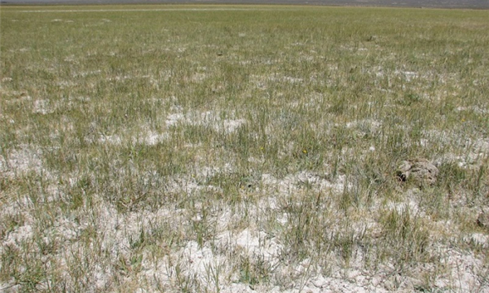
The plant community is dominated by alkali sacaton with lesser but significant amounts of alkali muhly, bluegrass, inland saltgrass and alkali cordgrass.
Potential vegetative composition is about 90 percent grasses, 5 percent forbs and 5 percent shrubs.
Approximate ground cover (basal and crown) is 50 to 85 percent.
Figure 6. Annual production by plant type (representative values) or group (midpoint values)
Table 5. Annual production by plant type
Plant type
Low (kg/hectare)
Representative value (kg/hectare)
High (kg/hectare)
Grass/Grasslike
549
785
1177
Shrub/Vine
196
280
420
Forb
39
56
84
Total
784
1121
1681
Community 1.2 Black greasewood/Alkali sacaton
Black greasewood and other shrubs increase in the absence of disturbance. Decadent shrubs dominate the overstory and deep-rooted perennial bunchgrasses in the understory are reduced either from competition with shrubs, herbivory, drought or combinations of these.
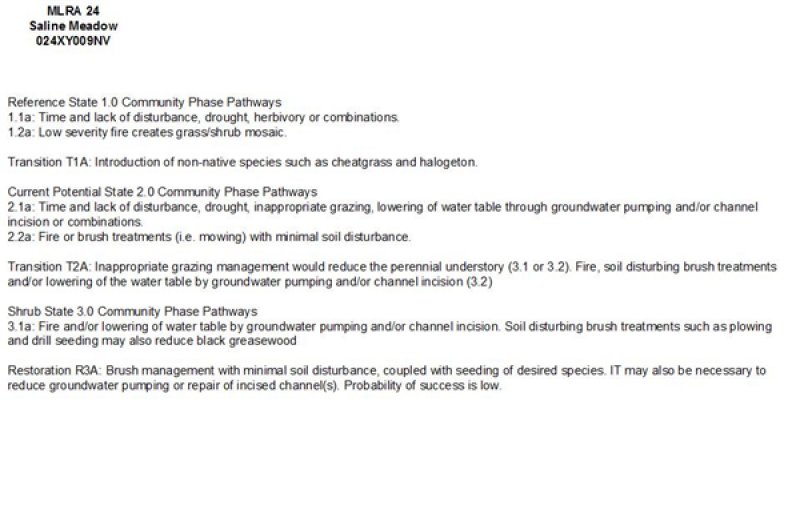
Pathway 1.1a Community 1.1 to 1.2
Absence of disturbance over time, significant herbivory, long term drought or combinations of these would allow the black greasewood overstory to dominate the site and reduce the perennial bunchgrasses. Inland saltgrass may increase in the understory depending on the timing and intensity of herbivory. Heavy spring utilization will favor an increase in black greasewood.
Pathway 1.2a Community 1.2 to 1.1
Low severity fire creates a grass/shrub mosaic.
State 2 Current Potential State
This state is similar to the Reference State 1.0 with two similar community phases. Ecological function has not changed, however the resiliency of the state has been reduced by the presence of invasive weeds. Non-natives may increase in abundance but will not become dominant within this State. These non-natives can be highly flammable and can promote fire where historically fire had been infrequent. Negative feedbacks enhance ecosystem resilience and contribute to the stability of the state. These feedbacks include the presence of all structural and functional groups, low fine fuel loads, and retention of organic matter and nutrients. Positive feedbacks decrease ecosystem resilience and stability of the state. These include the non-natives’ high seed output, persistent seed bank, rapid growth rate, ability to cross pollinate, and adaptations for seed dispersal.
Community 2.1 Alkali sacaton/greasewood
This community is dominated by alkali sacaton and black greasewood. Alkali muhly and rabbitbrush are also common on these sites. Inland saltgrass, alkaligrass and other perennial bunchgrasses and shrubs make up smaller components. Non-native annual species such as halogeton and cheatgrass are present.
Community 2.2 Black greasewood/perennial bunchgrasses
Black greasewood and big sagebrush increase in the absence of disturbance. Decadent shrubs dominate the overstory and deep-rooted perennial bunchgrasses in the understory are reduced either from competition with shrubs, inappropriate grazing management, drought or combinations of these.
Pathway 2.1a Community 2.1 to 2.2
Time and lack of disturbance, drought, inappropriate grazing, lowering of water table through groundwater pumping and/or channel incision or combinations of these.
Pathway 2.2a Community 2.2 to 2.1
Fire or brush treatments with minimal soil disturbance.
State 3 Shrub State
This state has two community phases, one that is characterized by a co-dominance of black greasewood and rabbitbrush and the other with rabbitbrush overstory. This site has crossed a biotic threshold and site processes are being controlled by shrubs. Bare ground has increased.
Community 3.1 Black greasewood
Decadent black greasewood dominates the site. Perennial bunchgrasses are present but a minor component. Annual non-native species may be present and may be increasing in the understory.
Community 3.2 Rabbitbrush
Rabbitbrush dominates the overstory. Deep-rooted perennial bunchgrasses may be present in trace amounts or absent from the community. Annual non-native species increase. Bare ground is significant.
Pathway 3.1a Community 3.1 to 3.2
Fire and/or lowering of water table by groundwater pumping and/or channel incision. Soil disturbing brush treatments such as plowing and drill seeding may also reduce black greasewood.
Transition T1A State 1 to 2
Introduction of non-native species such as cheatgrass and halogeton.
Transition T2A State 2 to 3
Inappropriate grazing management would reduce the perennial understory and/or lowering of the water table by groundwater pumping and/or channel incision.
Restoration pathway R3A State 3 to 2
Brush management with minimal soil disturbance, couple with seeing of desired species . It may also be necessary to reduce groundwater pumping or repair incised channel(s). Probability of success is low.
Additional community tables
Table 6. Community 1.1 plant community composition
Livestock Interpretations:
This site is suitable for livestock grazing. Grazing management should be keyed to dominant grasses. Alkali sacaton is a valuable forage species in arid and semiarid regions. Plants are tolerant to moderate grazing and can produce abundant herbage utilized by livestock. Nevada bluegrass is a palatable species, but its production is closely tied to weather conditions. It produces little forage in drought years, making it a less dependable food source than other perennial bunchgrasses. Saltgrass's value as forage depends primarily on the relative availability of other grasses of higher nutritional value and palatability. It can be an especially important late summer grass in arid environments after other forage grasses have deceased. Saltgrass is rated as a fair to good forage species only because it stays green after most other grasses dry. Livestock generally avoid saltgrass due to its coarse foliage. Saltgrass is described as an increaser under grazing pressure. Palatability for alkali cordgrass is low for livestock. The early growth and abundant production of basin wildrye make it a valuable source of forage for livestock. It is important forage for cattle and is readily grazed by cattle and horses in early spring and fall. Though coarse-textured during the winter, basin wildrye may be utilized more frequently by livestock and wildlife when snow has covered low shrubs and other grasses.
Stocking rates vary over time depending upon season of use, climate variations, site, and previous and current management goals. A safe starting stocking rate is an estimated stocking rate that is fine tuned by the client by adaptive management through the year and from year to year.
Wlidlife Interpretations:
The western salt desert shrub and grassland communities where alkali sacaton is common support an abundance of mule deer, pronghorn, carnivores, small mammals, birds, amphibians, and reptiles. Saltgrass provides cover for a variety of bird species, small mammals, and arthropods and is on occasion used as forage for several big game wildlife species. Palatability for alkali cordgrass is low for wildlife. Basin wildrye provides winter forage for mule deer, though use is often low compared to other native grasses. Basin wildrye provides summer forage for black-tailed jackrabbits. Because basin wildrye remains green throughout early summer, it remains available for small mammal forage for longer time than other grasses.
Hydrological functions
Runoff is high. Permeability is slow to moderate. Hydrologic soil group is C. Rills are none. Water flow patterns are none. Pedestals are none. Gullies are none to rare. Deep-rooted perennial grasses (alkali sacaton) and/or rhizomatous grasses slow runoff and increase infiltration. Shrub canopy and associated litter break raindrop impact and provide opportunity for snow catch and moisture accumulation on site.
Recreational uses
Aesthetic value is derived from the diverse floral and faunal composition and the colorful flowering of wild flowers and shrubs during the spring and early summer. This site offers rewarding opportunities to photographers and for nature study. This site has potential for upland bird and big game hunting.
Other products
Basin wildrye was used as bedding for various Native American ceremonies, providing a cool place for dancers to stand.
Other information
Alkali sacaton is one of the most commonly used species for seeding and stabilizing disturbed lands. Due to alkali sacaton’s salt tolerance, is recommended for native grass seeding on subirrigated saline sites. Given its extensive system of rhizomes and roots which form a dense sod, saltgrass is considered a suitable species for controlling wind and water erosion. Basin wildrye is useful in mine reclamation, fire rehabilitation and stabilizing disturbed areas. Its usefulness in range seeding, however, may be limited by initially weak stand establishment.
Supporting information
Type locality
Location 1: Lander County, NV
Township/Range/Section
T19N R42E S25
UTM zone
N
UTM northing
5247786
UTM easting
401251
Latitude
47° 22′ 33″
Longitude
106° 18′ 29″
General legal description
NW¼ Approximately 6 miles west of Austin, along USHwy 50 at Reese River Crossing, Lander County, Nevada. This site also occurs in Elko, Eureka, Humboldt and Pershing Counties, Nevada.
Marcum, K.B. and D.H. Kopec. 1997. Salinity tolerance of turfgrasses and alternative species in the subfamily Chloridoideae (Poaceae). International Turfgrass Society Research Journal 8:735-742.
Ogle, D.G., St. John, L., and D. Tilley. 2012b. Plant Guide for fourwing saltbush (Atriplex canescens). USDA Natural Resources Conservation Service, Aberdeen, ID Plant Materials Center. 83210-0296.
Perryman, B.L. and Q.D. Skinner. 2007. A field guide to Nevada Grasses. Indigenous Rangeland Management Press, Lander, Wyoming. 256 p.
Reynolds, T.D., and L. Fraley Jr. 1989. Root profiles of some native and exotic plant species in southeastern Idaho. Environmental and Experimental Botany. 29(2): 241-248.
Stuart, D.M., G.E. Schuman, and A.S. Dylla. 1971. Chemical characteristics of the coppice dune soils in Paradise Valley, Nevada. Proceedings of the Soil Science Society of America 34:607-611.
Interpreting Indicators of Rangeland Health is a qualitative assessment protocol used to
determine ecosystem condition based on benchmark characteristics described in the Reference Sheet. A suite of 17 (or
more) indicators are typically considered in an assessment. The ecological site(s) representative of an assessment
location must be known prior to applying the protocol and must be verified based on soils and climate. Current plant
community cannot be used to identify the ecological site.
Author(s)/participant(s)
Patti Novak-Echenique
Contact for lead author
State Rangeland Management Specialist
Date
12/17/2009
Approved by
Kendra Moseley
Approval date
Composition (Indicators 10 and 12) based on
Annual Production
Indicators
Number and extent of rills:
Rills are none.
Presence of water flow patterns:
This site is typically level and flow patterns are not common. Water flow patterns may be present if this site experiences flooding during spring runoff or after summer convection storms.
Number and height of erosional pedestals or terracettes:
Pedestals are none.
Bare ground from Ecological Site Description or other studies (rock, litter, lichen, moss, plant canopy are
not bare ground):
Bare Ground ± 5-15%.
Number of gullies and erosion associated with gullies:
Gullies are none
Extent of wind scoured, blowouts and/or depositional areas:
None
Amount of litter movement (describe size and distance expected to travel):
Fine litter (foliage of grasses and annual & perennial forbs) only expected to move during periods of flooding by adjacent streams. Persistent litter (large woody material) will remain in place except during major flooding events.
Soil surface (top few mm) resistance to erosion (stability values are averages - most sites will show a range
of values):
Soil stability values will range from 3 to 6. (To be field tested.)
Soil surface structure and SOM content (include type of structure and A-horizon color and thickness):
Structure of soil surface is typically platy. Soil surface colors are dark grayish browns and soils are typified by an ochric or mollic epipedon. Organic matter can range from 1.5 to 4.5 percent (OM values taken from lab characterization data.).
Effect of community phase composition (relative proportion of different functional groups) and spatial
distribution on infiltration and runoff:
Deep-rooted perennial grasses (alkali sacaton) and/or rhizomatous grasses slow runoff and increase infiltration. Shrub canopy and associated litter break raindrop impact and provide opportunity for snow catch and moisture accumulation on site.
Presence and thickness of compaction layer (usually none; describe soil profile features which may be
mistaken for compaction on this site):
Compacted layers are not typical. Platy, subangular blocky, prismatic, or massive subsurface layers are normal for this site and are not to be interpreted as compaction.
Functional/Structural Groups (list in order of descending dominance by above-ground annual-production or live foliar
cover using symbols: >>, >, = to indicate much greater than, greater than, and equal to):
Amount of plant mortality and decadence (include which functional groups are expected to show mortality or
decadence):
Dead branches within individual shrubs common and standing dead shrub canopy material may be as much as 25% of total woody canopy
Average percent litter cover (%) and depth ( in):
Within plant interspaces (± 35%) and depth of litter ± ½ inch.
Expected annual annual-production (this is TOTAL above-ground annual-production, not just forage annual-production):
For normal or average growing season (through end of May) ± 1000 lbs/ac; Winter moisture significantly affects total production. Favorable years ± 1500 lbs/ac and unfavorable years ±700 lbs/ac.
Potential invasive (including noxious) species (native and non-native). List species which BOTH characterize
degraded states and have the potential to become a dominant or co-dominant species on the ecological site if
their future establishment and growth is not actively controlled by management interventions. Species that become
dominant for only one to several years (e.g., short-term response to drought or wildfire) are not invasive
plants. Note that unlike other indicators, we are describing what is NOT expected in the reference state for the
ecological site:
Potential invaders include annual mustards, annual kochia, pigweed, thistles, halogeton, and tall whitetop (perennial pepperweed).
Perennial plant reproductive capability:
All functional groups should reproduce in average (or normal) and above average growing season years. Reduced growth and reproduction occur during extreme or extended drought conditions.
The Ecosystem Dynamics Interpretive Tool is an information system framework developed by the USDA-ARS Jornada Experimental Range, USDA Natural Resources Conservation Service, and New Mexico State University.
Click on box and path labels to scroll to the respective text.