Natural Resources
Conservation Service
Ecological site R023XY079NV
ASHY CLAYPAN (COOL) 10-14 P.Z.
Last updated: 4/10/2025
Accessed: 04/03/2026
General information
Provisional. A provisional ecological site description has undergone quality control and quality assurance review. It contains a working state and transition model and enough information to identify the ecological site.
Ecological site concept
Currently there is only a draft of the initial concept for this ecological site. The initial concept for this site places it within the Ashy 10-14” PZ Lahontan Sagebrush on Ashy Soils Ecological Site Group. To view the General STM and other information available for this ESG please go to https://edit.jornada.nmsu.edu/catalogs/esg/023X/R023XY903NV
This site occurs on north- facing aspects of shoulders and sideslopes of plateaus and lower mountains. Slopes range from 2 to 50 percent, but slope gradients of 2 to 8 percent are most typical. Elevations are 5800 to 7300 feet. Average annual precipitation is 10 to 14 inches. The soils in this site are shallow to moderately deep and well drained. Surface soils are medium to moderately coarse textured and are underlain by medium textured subsoils. Available water capacity is moderate. There are very high amounts of vitric volcanic ash and glass throughout the soil profile which enhances the water holding capacity of these soils. Infiltration is rapid and permeability is moderate. Runoff is medium and the potential for sheet and rill erosion is moderate to high depending on slope. The plant community is dominated by Lahontan/low sagebrush, Idaho fescue, needlegrasses, and other perennial forbs. Normal year annual production is 900 lb/ac, but ranges from 600 – 1200 lb/ac.
Associated sites
| R023XY007NV |
LOAMY 14-16 P.Z. |
|---|---|
| R023XY014NV |
SHALLOW LOAM 14+ P.Z. |
| R023XY078NV |
ASHY CLAYPAN 10-14 P.Z. |
Similar sites
| R023XY078NV |
ASHY CLAYPAN 10-14 P.Z. PSSPS-ACTH7 codominant |
|---|---|
| R023XY021NV |
SCABLAND 10-14 P.Z. POSE dominant grass; much less productive site |
| R023XY014NV |
SHALLOW LOAM 14+ P.Z. higher elevations; less productive site |
| R023XY017NV |
CLAYPAN 14-16 P.Z. FEID-PSSPS codominant |
| R023XY044NV |
VERY COBBLY CLAYPAN POSE dominant grass; less productive site; extremely cobbly surface |
| R023XY008NV |
MOUNTAIN RIDGE much less productive site |
| R023XY060NV |
COBBLY CLAYPAN 8-12 P.Z. less productive site; many cobbles on surface |
| R023XY059NV |
GRAVELLY CLAYPAN 10-12 P.Z. PSSPS dominant grass; less productive site |
| R023XY031NV |
CLAYPAN 10-14 P.Z. PSSPS-ACTH7 codominant |
Table 1. Dominant plant species
| Tree |
Not specified |
|---|---|
| Shrub |
(1) Artemisia arbuscula |
| Herbaceous |
(1) Festuca idahoensis |
Physiographic features
This site occurs on north-facing aspects of shoulders and backslopes of plateaus and lower mountains. Slopes range from 4 to 50 percent, but slope gradients of 2 to 8 percent are most typical. Elevations are 5900 to 6900 feet.
Table 2. Representative physiographic features
| Landforms |
(1)
Mountain
(2) Plateau |
|---|---|
| Elevation | 5,900 – 6,900 ft |
| Slope | 4 – 50% |
| Aspect | N |
Climatic features
The climate associated with this site is semiarid and characterized by cool, moist winters and warm, dry summers. Average annual precipitation is 10 to 14 inches. Mean annual air temperature is 43 to 45 degrees F. The average growing season is about 80 to 100 days.
Nevada’s climate is predominantly arid, with large daily ranges of temperature, infrequent severe storms, heavy snowfall in the higher mountains, and great location variations with elevation. Three basic geographical factors largely influence Nevada’s climate: continentality, latitude, and elevation. Continentality is the most important factor. The strong continental effect is expressed in the form of both dryness and large temperature variations. Nevada lies on the eastern, lee side of the Sierra Nevada Range, a massive mountain barrier that markedly influences the climate of the State. The prevailing winds are from the west, and as the warm moist air from the Pacific Ocean ascend the western slopes of the Sierra Range, the air cools, condensation occurs and most of the moisture falls as precipitation. As the air descends the eastern slope, it is warmed by compression, and very little precipitation occurs. The effects of this mountain barrier are felt not only in the West but throughout the state, with the result that the lowlands of Nevada are largely desert or steppes. The temperature regime is also affected by the blocking of the inland-moving maritime air. Nevada sheltered from maritime winds, has a continental climate with well-developed seasons and the terrain responds quickly to changes in solar heating.
Nevada lies within the mid-latitude belt of prevailing westerly winds which occur most of the year. These winds bring frequent changes in weather during the late fall, winter and spring months, when most of the precipitation occurs. To the south of the mid-latitude westerlies, lies a zone of high pressure in subtropical latitudes, with a center over the Pacific Ocean. In the summer, this high-pressure belt shifts northward over the latitudes of Nevada, blocking storms from the ocean. The resulting weather is mostly clear and dry during the summer and early fall, with scattered thundershowers. The eastern portion of the state receives significant summer thunderstorms generated from monsoonal moisture pushed up from the Gulf of California, known as the North American monsoon. The monsoon system peaks in August and by October the monsoon high over the Western U.S. begins to weaken and the precipitation retreats southward towards the tropics (NOAA 2004).
Average annual precipitation is 16 to over 20 inches. Mean annual air temperature is 41 to 44 degrees F. The average growing season is about 50 to 70 days.
Mean annual precipitaion at the Bear Creek, Nevada SNOTEL station (170501020301) is 37.69 inches.
monthly mean precipitation is:
January 3.84; February 3.75; March 4.38; April 4.9;
May 3.99; June 2.82; July .95; August 1.66;
September 1.22; October 2.12;
November 3.67; December 4.38.
Table 3. Representative climatic features
| Frost-free period (average) | 90 days |
|---|---|
| Freeze-free period (average) | |
| Precipitation total (average) | 12 in |
Figure 1. Monthly precipitation range
Figure 2. Monthly average minimum and maximum temperature
Figure 3. Annual precipitation pattern
Figure 4. Annual average temperature pattern
Influencing water features
There are no influencing water features associated with this site.
Soil features
The soils associate with this site are shallow to moderately deep and well drained. These soils are formed in residuum and colluvium derived from pyroelastic and extrusive volcanic rocks. Surface soils are medium to moderately coarse textured and are underlain by medium textured subsoils. Available water capacity is moderate. There are very high amounts of vitric volcanic ash and glass throughout the soil profile which enhances the water holding capacity of these soils. Infiltration is rapid and permeability is moderately slow. Runoff is high to very high and the potential for sheet and rill erosion is moderate to high depending on slope. These soils have a mollic epipedon. The soil series associated with this site include: Ashodos.
Table 4. Representative soil features
| Surface texture |
(1) Very gravelly sandy loam |
|---|---|
| Family particle size |
(1) Loamy |
| Drainage class | Well drained |
| Permeability class | Moderately slow |
| Soil depth | 20 – 40 in |
| Surface fragment cover <=3" | 40 – 50% |
| Surface fragment cover >3" | 1% |
| Available water capacity (0-40in) |
3.6 – 3.7 in |
| Calcium carbonate equivalent (0-40in) |
Not specified |
| Electrical conductivity (0-40in) |
Not specified |
| Sodium adsorption ratio (0-40in) |
Not specified |
| Soil reaction (1:1 water) (0-40in) |
6.6 – 7.8 |
| Subsurface fragment volume <=3" (Depth not specified) |
14 – 35% |
| Subsurface fragment volume >3" (Depth not specified) |
1% |
Ecological dynamics
An ecological site is the product of all the environmental factors responsible for its development and it has a set of key characteristics that influence a site’s resilience to disturbance and resistance to invasives. Key characteristics include 1) climate (precipitation, temperature), 2) topography (aspect, slope, elevation, and landform), 3) hydrology (infiltration, runoff), 4) soils (depth, texture, structure, organic matter), 5) plant communities (functional groups, productivity), and 6) natural disturbance regime (fire, herbivory, etc.) (Caudle et al. 2013). Biotic factors that that influence resilience include site productivity, species composition and structure, and population regulation and regeneration (Chambers et al. 2013).
The ecological sites in this DRG are dominated by deep-rooted cool season, perennial bunchgrasses and long-lived shrubs (50+ years) with high root to shoot ratios. The dominant shrubs usually root to the full depth of the winter-spring soil moisture recharge, which ranges from 1.0 to over 3.0 m (Dobrowolski et al. 1990). However, community types with low sagebrush as the dominant shrub may only have available rooting depths of 71 to 81 cm (Jensen 1990). These shrubs have a flexible generalized root system with development of both deep taproots and laterals near the surface (Comstock and Ehleringer 1992).
Periodic drought regularly influences sagebrush ecosystems and drought duration and severity has increased throughout the 20th century in much of the Intermountain West. Major shifts away from historical precipitation patterns have the greatest potential to alter ecosystem function and productivity. Species composition and productivity can be altered by the timing of precipitation and water availability with the soil profile (Bates et al. 2006).
Low sagebrush is fairly drought tolerant but also tolerates periodic wetness during some portion of the growing season (Fosberg and Hironaka 1964, Blackburn et al. 1968a and b, 1969a and b). It grows on soils that have a strongly-structured B2t (argillic) horizon close to the soil surface (Winward 1980, Fosberg and Hironaka 1964, Zamora and Tueller 1973). Low sagebrush is also susceptible to the sagebrush defoliator, Aroga moth. Aroga moth can partially or entirely kill individual plants or entire stands of big sagebrush (Furniss and Barr 1975), but research is inconclusive of the damage sustained by low sagebrush populations.
Lahontan sagebrush was only recently identified as a unique species of sagebrush (Winward and McArthur 1995). Lahontan sagebrush is a cross between low sagebrush and Wyoming sagebrush (Artemisia tridentata ssp. wyomingensis) and is typically found near the old shorelines of Lake Lahontan from the Pleistocene epoch. This subspecies grows on soils similar to low sagebrush with shallow depths and low water holding capabilities (Winward and McArthur 1995).
Utah juniper is a long-lived tree species with wide ecological amplitudes (Tausch et al. 1981, West et al. 1998, Weisberg and Ko 2012). Maximum ages of pinyon and juniper exceed 1000 years and stands with maximum age classes are only found on steep rocky slopes with no evidence of fire (West et al. 1975).
Infilling by younger trees increases canopy cover causing a decrease in understory perennial vegetation and an increase in bare ground. As juniper trees increase in density so does their litter. Phenolic compounds of juniper scales can have an inhibitory effect on grass growth (Jameson 1970).
Furthermore, infilling shifts stand level biomass from ground fuels to canopy fuels which has the potential to significantly impact fire behavior. The more tree-dominated the site becomes, the less likely they are to burn under moderate conditions, resulting in infrequent high intensity fires (Gruell 1999, Miller et al. 2008). Additionally, as the understory vegetation declines in vigor and density with increased canopy, the seed and propagules of the understory plant community also decrease significantly. The increase in bare ground allows for the invasion of non-native annual species such as cheatgrass. With intensive wildfire, the potential for conversion to annual exotics is a serious threat (Tausch 1999, Miller et al. 2008).
Juniper growth is dependent mostly upon soil moisture stored from winter precipitation, mainly snow. Much of the summer precipitation is ineffective, being lost in runoff after summer convection storms or by evaporation and interception (Tueller and Clark 1975). Juniper is highly resistant to drought, which is common in the Great Basin. Tap roots of juniper have a relatively rapid rate of root elongation and are thus able to persist until precipitation conditions are more favorable (Emerson 1932). At the southern end of this site's extent, Utah Juniper may be the dominant species or may coexist and/or hybridize with Western Juniper.
The Great Basin sagebrush communities have high spatial and temporal variability in precipitation both among years and within growing seasons (MacMahon 1980). Nutrient availability is typically low but increases with elevation and closely follows moisture availability. The invasibility of plant communities is often linked to resource availability. Disturbance changes resource uptake and increases nutrient availability, often to the benefit of non-native species; native species are often damaged and their ability to use resources is depressed for a time, but resource pools may increase from lack of use and/or the decomposition of dead plant material following disturbance (Whisenant 1999, Miller et al. 2013). The invasion of sagebrush communities by cheatgrass (Bromus tectorum) has been linked to disturbances (fire, abusive grazing) that have resulted in fluctuations in resources (Beckstead and Augspurger 2004, Chambers et al. 2007, Johnson et al. 2011).
This ecological site has low to moderate resilience to disturbance and resistance to invasion. Increased resilience increases with elevation, aspect, increased precipitation and increased nutrient availability.
Annual Invasive Grasses:
The species most likely to invade these sites are cheatgrass and medusahead. Both species are cool-season annual grasses that maintain an advantage over native plants in part because they are prolific seed producers, able to germinate in the autumn or spring, tolerant of grazing, and increase with frequent fire (Klemmedson and Smith 1964, Miller et al. 1999). Medusahead and cheatgrass originated from Eurasia and both were first reported in North America in the late 1800s (Mack and Pyke 1983; Furbush 1953). Pellant and Hall (1994) found 3.3 million acres of public lands dominated by cheatgrass and suggested that another 76 million acres were susceptible to invasion by winter annuals including cheatgrass and medusahead. By 2003, medusahead occupied approximately 2.3 million acres in 17 western states (Rice 2005). In the Intermountain West, the exponential increase in dominance by medusahead has largely been at the expense of cheatgrass (Harris 1967, Hironaka 1994). Medusahead matures 2-3 weeks later than cheatgrass (Harris 1967) and recently, James et al. (2008) measured leaf biomass over the growing season and found that medusahead maintained vegetative growth later in the growing season than cheatgrass. Mangla et al. (2011) also found medusahead had a longer period of growth and more total biomass than cheatgrass and hypothesized this difference in relative growth rate
may be due to the ability of medusahead to maintain water uptake as upper soils dry compared to co-occurring species, especially cheatgrass. Medusahead litter has a slow decomposition rate, because of high silica content, allowing it to accumulate over time and suppress competing vegetation (Bovey et al. 1961, Davies and Johnson 2008). Harris (1967) reported medusahead roots have thicker cell walls compared to those of cheatgrass, allowing it to more effectively conduct water, even in very dry conditions.
Recent modeling and empirical work by Bradford and Lauenroth (2006) suggests that seasonal patterns of precipitation input and temperature are also key factors determining regional variation in the growth, seed production, and spread of invasive annual grasses. Collectively, the body of research suggests that the continued invasion and dominance of medusahead onto native grasslands and cheatgrass infested grasslands will continue to increase in severity because conditions that favor native bunchgrasses or cheatgrass over medusahead are rare (Mangla et al. 2011). Medusahead replaces native vegetation and cheatgrass directly by competition and suppression and native vegetation indirectly by increasing fire frequency.
Methods to control medusahead and cheatgrass include herbicide, fire, grazing, and seeding of primarily non-native wheatgrasses. Mapping potential or current invasion vectors is a management method designed to increase the cost effectiveness of control methods. A study by Davies et al. (2013), found an increase in medusahead cover near roads. Cover was higher near animal trails than random transects but the difference was less evident. This implies that vehicles and animals aid the spread of the weed; however, vehicles are the major vector of movement. Spraying with herbicide (Imazapic or Imazapic + glyphosate) and seeding with crested wheatgrass and Sandberg bluegrass has been found to be more successful at combating medusahead and cheatgrass than spraying alone (Sheley et al. 2012). Where native bunchgrasses are missing from the site, revegetation of medusahead or cheatgrass invaded rangelands has been shown to have a higher likelihood of success when using introduced perennial bunchgrasses such as crested wheatgrass (Davies et al. 2015). Butler et al. (2011) tested four herbicides (Imazapic, Imazapic + glyphosate, rimsulfuron and sulfometuron + Chlorsulfuron) only treatments for suppression of cheatgrass, medusahead and ventenata (North Africa grass, Ventenata dubia) within residual stands of native bunchgrass. Additionally, they tested the same four herbicides followed by seeding of six bunchgrasses (native and non-native) with varying success (Butler et al. 2011). Herbicide only treatments appeared to remove competition for established bluebunch wheatgrass by providing 100% control of ventenata and medusahead and greater than 95% control of cheatgrass (Butler et al. 2011), however caution in using these results is advised, as only one year of data was reported. Prescribed fire has also been utilized in combination with the application of pre-emergent herbicide to control medusahead and cheatgrass (Vollmer and Vollmer 2008). Mature medusahead or cheatgrass is very flammable and fire can be used to remove the thatch layer, consume standing vegetation, and even reduce seed levels. Furbush (1953) reported that timing a burn while the seeds were in the milk stage effectively reduced medusahead the following year. He further reported that adjacent unburned areas became a seed source for reinvasion the following year.
In considering the combination of pre-emergent herbicide and prescribed fire for invasive annual grass control, it is important to assess the tolerance of desirable brush species to the herbicide being applied. Vollmer and Vollmer (2008) tested the tolerance of mountain mahogany (Cercocarpus montanus), antelope bitterbrush, and multiple sagebrush species to three rates of Imazapic and the same rates with methylated seed oil as a surfactant. They found a cheatgrass control program in an antelope bitterbrush community should not exceed Imazapic at 8 oz/ac with or without surfactant. Sagebrush, regardless of species or rate of application, was not affected. However, many environmental variables were not reported in this study and managers should install test plots before broad scale herbicide application is initiated.
State and transition model
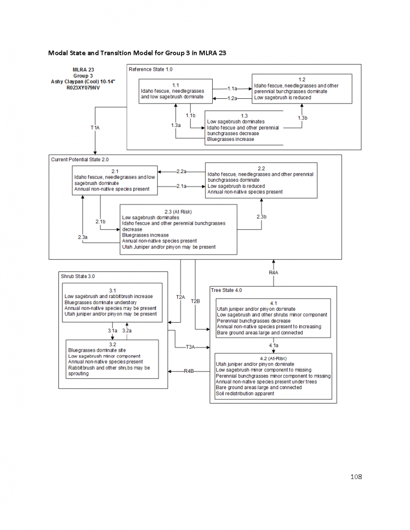

More interactive model formats are also available.
View Interactive Models
Click on state and transition labels to scroll to the respective text
Ecosystem states
State 1 submodel, plant communities
State 1
Reference Plant Community
Community 1.1
Reference Plant Community
The reference plant community is dominated by Idaho fescue and low sagebrush. Thurber’s needlegrass and western needlegrass are important species associated with this site. Potential vegetative composition is about 70% grasses, 10% forbs and 20% shrubs. Approximate ground cover (basal and crown) is about 35 to 45 percent.
Figure 5. Annual production by plant type (representative values) or group (midpoint values)
Table 5. Annual production by plant type
| Plant type | Low (lb/acre) |
Representative value (lb/acre) |
High (lb/acre) |
|---|---|---|---|
| Grass/Grasslike | 420 | 630 | 840 |
| Shrub/Vine | 108 | 162 | 216 |
| Forb | 60 | 90 | 120 |
| Tree | 12 | 18 | 24 |
| Total | 600 | 900 | 1200 |
Community 1.2
State 2
State 3
State 4
Additional community tables
Table 6. Community 1.1 plant community composition
| Group | Common name | Symbol | Scientific name | Annual production (lb/acre) | Foliar cover (%) | |
|---|---|---|---|---|---|---|
|
Grass/Grasslike
|
||||||
| 1 | Primary Perennial Grasses | 513–855 | ||||
| Idaho fescue | FEID | Festuca idahoensis | 360–540 | – | ||
| western needlegrass | ACOCO | Achnatherum occidentale ssp. occidentale | 45–90 | – | ||
| Thurber's needlegrass | ACTH7 | Achnatherum thurberianum | 45–90 | – | ||
| bluebunch wheatgrass | PSSPS | Pseudoroegneria spicata ssp. spicata | 18–45 | – | ||
| Cusick's bluegrass | POCUE2 | Poa cusickii ssp. epilis | 15–30 | – | ||
| 2 | Secondary Perennial Grasses/Grasslikes | 18–72 | ||||
| sedge | CAREX | Carex | 5–27 | – | ||
| big squirreltail | ELMU3 | Elymus multisetus | 5–27 | – | ||
| prairie Junegrass | KOMA | Koeleria macrantha | 5–27 | – | ||
| Sandberg bluegrass | POSE | Poa secunda | 5–27 | – | ||
|
Forb
|
||||||
| 3 | Perennial | 45–135 | ||||
| aster | ASTER | Aster | 5–27 | – | ||
| milkvetch | ASTRA | Astragalus | 5–27 | – | ||
| arrowleaf balsamroot | BASA3 | Balsamorhiza sagittata | 5–27 | – | ||
| tapertip hawksbeard | CRAC2 | Crepis acuminata | 5–27 | – | ||
| fleabane | ERIGE2 | Erigeron | 5–27 | – | ||
| buckwheat | ERIOG | Eriogonum | 5–27 | – | ||
| lupine | LUPIN | Lupinus | 5–27 | – | ||
|
Shrub/Vine
|
||||||
| 4 | Primary Shrubs | 90–180 | ||||
| little sagebrush | ARAR8 | Artemisia arbuscula | 90–180 | – | ||
| 5 | Secondary Shrubs | 18–90 | ||||
| Utah serviceberry | AMUT | Amelanchier utahensis | 9–27 | – | ||
| yellow rabbitbrush | CHVI8 | Chrysothamnus viscidiflorus | 9–27 | – | ||
| antelope bitterbrush | PUTR2 | Purshia tridentata | 9–27 | – | ||
| currant | RIBES | Ribes | 9–27 | – | ||
| mountain snowberry | SYOR2 | Symphoricarpos oreophilus | 9–27 | – | ||
|
Tree
|
||||||
| 6 | Evergreen | 5–18 | ||||
| western juniper | JUOC | Juniperus occidentalis | 5–18 | – | ||
Interpretations
Animal community
Livestock/Wildlife Grazing Interpretations:
Domestic sheep and, to a much lesser degree, cattle consume low sagebrush, particularly during the spring, fall, and winter (Sheehy and Winward 1981). Heavy dormant season grazing by sheep will reduce sagebrush cover and increase grass production (Laycock 1967). Trampling damage, particularly from cattle or horses, in low sagebrush habitat types is greatest in areas with high clay content soils during spring snowmelt when surface soils are saturated. In drier areas with more gravelly soils, trampling is less of a problem (Hironaka et al. 1983). Bunchgrasses, in general, best tolerate light grazing after seed formation. Britton et al. (1990) observed the effects of clipping date on basal area of five bunchgrasses in eastern Oregon, and found grazing from August to October (after seed set) has the least impact. Heavy grazing during the growing season will reduce perennial bunchgrasses and increase sagebrush (Laycock 1967). Abusive grazing by cattle or horses allows unpalatable plants like low sagebrush, rabbitbrush and some forbs such as arrowleaf balsamroot to become dominant on the site. Sandberg bluegrass is also grazing tolerant due to its short stature. Annual non-native weedy species such as cheatgrass, mustards, and medusahead may invade.
Throughout two years of site visits for this report, Lahontan sagebrush was observed in a heavily-browsed state on this ecological site and others in this DRG. This recently differentiated subspecies of low sagebrush (Winward and McArthur 1995) is moderately to highly palatable to browse species (McArthur 2005, Rosentreter 2005). Dwarf sagebrush species such as Lahontan sagebrush, low sagebrush, and black sagebrush are preferred by mule deer for browse among the sagebrush species.
Bunchgrasses, in general, best tolerate light grazing after seed formation. Britton et al. (1990) observed the effects of clipping date on basal area of 5 bunchgrasses in eastern Oregon, and found grazing from August to October (after seed set) has the least impact. Heavy grazing during the growing season will reduce perennial bunchgrasses and increase sagebrush (Laycock 1967). Abusive grazing by cattle or
horses allows unpalatable plants like low sagebrush, rabbitbrush and some forbs such as arrowleaf balsamroot to become dominant on the site. Sandberg bluegrass is also grazing tolerant due to its short stature. Annual non-native weedy species such as cheatgrass, mustards, and medusahead may invade.
Inappropriate grazing practices can be tied to the success of medusahead, however, eliminating grazing will not eradicate medusahead if it is already present (Wagner et al. 2001). Sheley and Svejcar (2009) reported that even moderate defoliation of bluebunch wheatgrass resulted in increased medusahead density. They suggested that disturbances such as plant defoliation limit soil resource capture, which creates an opportunity for exploitation by medusahead. Avoidance of medusahead by grazing animals allows medusahead populations to expand. This creates seed reserves that can infest adjoining areas and cause changes to the fire regime. Medusahead replaces native vegetation and cheatgrass directly by competition and suppression and native vegetation indirectly by an increase in fire frequency. Medusahead litter has a slow decomposition rate, because of high silica content, allowing it to accumulate over time and suppress competing vegetation (Bovey et al. 1961, Davies and Johnson 2008).
Idaho fescue tolerates light to moderate grazing (Ganskopp and Bedell 1981) and is moderately resistant to trampling (Cole 1989). However, Idaho fescue decreases under heavy grazing by livestock (Eckert and Spencer 1986, Eckert and Spencer 1987) and wildlife (Gaffney 1941). Bunchgrasses, in general, best tolerate light grazing after seed formation. Britton and others (1979) observed the effects of harvest date on basal area of 5 bunchgrasses in eastern Oregon, including Idaho fescue, and found grazing from August to October (after seed set) has the least impact on these bunchgrasses. Therefore, abusive grazing during the growing season will reduce perennial bunchgrasses, with the exception of Sandberg bluegrass (Tisdale and Hironaka 1981). Abusive grazing by cattle or horses will likely increase low sagebrush, rabbitbrush and some forbs such as arrowleaf balsamroot. Annual non-native weedy species may invade, such as cheatgrass and mustards, and potentially medusahead.
Thurber’s needlegrass is an important forage source for livestock and wildlife in the arid regions of the West (Ganskopp 1988). Although the seeds are apparently not injurious, grazing animals avoid them when they begin to mature. Sheep, however, have been observed to graze the leaves closely, leaving stems untouched (Eckert and Spencer 1987). Heavy grazing during the growing season has been shown to reduce the basal area of Thurber’s needlegrass (Eckert and Spencer 1987), suggesting that both seasonality and utilization are important factors in management of this plant. A single defoliation, particularly during the boot stage, was found to reduce herbage production and root mass thus potentially lowering the competitive ability of this needlegrass (Ganskopp 1988).
Western wheatgrass (Pascopyrum smithii) and thickspike wheatgrass (Elymus lanceolatus) are two rhizomatous grasses that are often found on this site. Their rhizomatous growth habit makes these grasses tolerant to grazing and more likely to survive fire. These grasses may become more dominant under heavy grazing conditions.
Antelope bitterbrush a minor component on this site is a critical browse species for mule deer, antelope and elk and is often utilized heavily by domestic livestock (Wood 1995). Grazing tolerance is dependent on site conditions (Garrison 1953) and the shrub can be severely hedged during the dormant season for grasses and forbs.
Sandberg bluegrass increases under grazing pressure (Tisdale and Hironaka 1981) and is capable of co-existing with cheatgrass or other weedy species. Excessive sheep grazing favors Sandberg bluegrass; however, where cattle are the dominant grazers, cheatgrass often dominates (Daubenmire 1970). Thus, depending on the season of use, the grazer and site conditions, either Sandberg bluegrass or cheatgrass may become the dominant understory with inappropriate grazing management.
Hydrological functions
Runoff is high to very high. Permeability is moderately slow. Hydrologic soil group is C. Rills are rare. A few rills can be expected on steeper slopes in areas subjected to summer convection storms or rapid spring snowmelt. Water flow patterns are rare but can be expected in areas recently subjected to summer convection storms or rapid snowmelt, usually on steeper slopes. Pedestals are rare. Gullies are rare in areas of this site that occur on stable landforms. Perennial herbaceous plants (especially deep-rooted bunchgrasses [Idaho fescue & needlegrasses]) slow runoff and increase infiltration. Shrub canopy and associated litter break raindrop impact and provide opportunity for snow catch and accumulation on site.
Recreational uses
Aesthetic value is derived from the diverse floral and faunal composition and the colorful flowering of wild flowers and shrubs during the spring and early summer. This site offers rewarding opportunities to photographers and for nature study. This site is used for camping and hiking and has potential for upland and big game hunting.
Other information
Low sagebrush can be successfully transplanted or seeded in restoration.
Supporting information
Type locality
| Location 1: Humboldt County, NV | |
|---|---|
| Township/Range/Section | T42N R19E S5 |
| UTM zone | N |
| UTM northing | 260026 |
| UTM easting | 4608254 |
| Latitude | 41° 35′ 23″ |
| Longitude | 119° 52′ 44″ |
| General legal description | SE 1/4 NW 1/4, Approximately 1 mile west of Vya, along south side of the north fork of County Road 34, Forty-Niner Summit, Washoe County, Nevada. This site also occurs in Humboldt County, Nevada. |
Other references
Fire Effects Information System (Online; http://www.fs.fed.us/database/feis/plants/).
USDA-NRCS Plants Database (Online; http://www.plants.usda.gov).
Contributors
GKB
Approval
Kendra Moseley, 4/10/2025
Rangeland health reference sheet
Interpreting Indicators of Rangeland Health is a qualitative assessment protocol used to determine ecosystem condition based on benchmark characteristics described in the Reference Sheet. A suite of 17 (or more) indicators are typically considered in an assessment. The ecological site(s) representative of an assessment location must be known prior to applying the protocol and must be verified based on soils and climate. Current plant community cannot be used to identify the ecological site.
| Author(s)/participant(s) | P NOVAK-ECHENIQUE |
|---|---|
| Contact for lead author | State Rangeland Management Specialist |
| Date | 06/20/2006 |
| Approved by | Kendra Moseley |
| Approval date | |
| Composition (Indicators 10 and 12) based on | Annual Production |
Indicators
-
Number and extent of rills:
Rills are rare. A few rills can be expected on steeper slopes in areas subjected to summer convection storms or rapid spring snowmelt. -
Presence of water flow patterns:
Water flow patterns are rare but can be expected in areas recently subjected to summer convection storms or rapid snowmelt, usually on steeper slopes. Patterns are short (<1 m) and stable. -
Number and height of erosional pedestals or terracettes:
Pedestals are rare. Occurrence is limited to waterflow patterns. -
Bare ground from Ecological Site Description or other studies (rock, litter, lichen, moss, plant canopy are not bare ground):
Bare ground ± 40%; surface cover of rock fragments ± 35%; -
Number of gullies and erosion associated with gullies:
Gullies are rare in areas of this site that occur on stable landforms. -
Extent of wind scoured, blowouts and/or depositional areas:
None -
Amount of litter movement (describe size and distance expected to travel):
Fine litter (foliage from grasses and annual & perennial forbs) expected to move distance of slope length during intense summer convection storms or rapid snowmelt events. Persistent litter (large woody material) will remain in place except during large rainfall events. -
Soil surface (top few mm) resistance to erosion (stability values are averages - most sites will show a range of values):
Soil stability values should be 3 to 6 on most soil textures found on this site. -
Soil surface structure and SOM content (include type of structure and A-horizon color and thickness):
Surface structure is moderate very fine subangular blocky. Soil surface colors are grays and browns and soils are typified by a mollic epipedon. Organic matter of the surface 2 to 4 inches is typically 1.25 to 3 percent dropping off quickly below. Organic matter content can be more or less depending on micro-topography. -
Effect of community phase composition (relative proportion of different functional groups) and spatial distribution on infiltration and runoff:
Perennial herbaceous plants (especially deep-rooted bunchgrasses [Idaho fescue & needlegrasses]) slow runoff and increase infiltration. Shrub canopy and associated litter break raindrop impact and provide opportunity for snow catch and accumulation on site. -
Presence and thickness of compaction layer (usually none; describe soil profile features which may be mistaken for compaction on this site):
Compacted layers are none. Angular blocky structure or subsoil argillic horizons are not to be interpreted as compacted. -
Functional/Structural Groups (list in order of descending dominance by above-ground annual-production or live foliar cover using symbols: >>, >, = to indicate much greater than, greater than, and equal to):
Dominant:
Deep-rooted, cool season, perennial bunchgrassesSub-dominant:
low shrubs (low sagebrush) = deep-rooted, cool season, perennial forbs >associated shrubs = fibrous, shallow-rooted, cool season, perennial and annual forbs > shallow-rooted, cool season, perennial bunchgrasses.Other:
evergreen treesAdditional:
-
Amount of plant mortality and decadence (include which functional groups are expected to show mortality or decadence):
Dead branches within individual shrubs common and standing dead shrub canopy material may be as much as 25% of total woody canopy; some of the mature bunchgrasses (<10%) have dead centers. -
Average percent litter cover (%) and depth ( in):
Between plant interspaces (30-40%) and litter depth is ± ¼ inch. -
Expected annual annual-production (this is TOTAL above-ground annual-production, not just forage annual-production):
For normal or average growing season (through mid-June) ± 900 lbs/ac; Favorable years: + 1200 lbs/ac; Unfavorable years: + 600 lbs/ac -
Potential invasive (including noxious) species (native and non-native). List species which BOTH characterize degraded states and have the potential to become a dominant or co-dominant species on the ecological site if their future establishment and growth is not actively controlled by management interventions. Species that become dominant for only one to several years (e.g., short-term response to drought or wildfire) are not invasive plants. Note that unlike other indicators, we are describing what is NOT expected in the reference state for the ecological site:
Potential invaders include cheatgrass and annual mustards.; Western juniper may increase and eventually dominate this site. -
Perennial plant reproductive capability:
All functional groups should reproduce in average (or normal) and above average growing season years. Reduced growth and reproduction occurs during drought years.
Print Options
Sections
Font
Other
The Ecosystem Dynamics Interpretive Tool is an information system framework developed by the USDA-ARS Jornada Experimental Range, USDA Natural Resources Conservation Service, and New Mexico State University.
Click on box and path labels to scroll to the respective text.