
Natural Resources
Conservation Service
Ecological site R023XY008NV
MOUNTAIN RIDGE
Last updated: 4/10/2025
Accessed: 04/26/2025
General information
Provisional. A provisional ecological site description has undergone quality control and quality assurance review. It contains a working state and transition model and enough information to identify the ecological site.
Ecological site concept
Currently there is only a draft of the initial concept for this ecological site. The initial concept for this site places it within the Shallow and Mod Deep >12” PZ Low and Lahontan sagebrush and Idaho fescue Ecological Site Group. To view the General STM and other information available for this ESG please go to https://edit.jornada.nmsu.edu/catalogs/esg/023X/R023XY902OR
This site is significantly less productive than the group modal with an average of 250 lb/ac in normal years. The dominant plants are the same however there may be a component of black sagebrush. This site occurs on windswept mountain ridges. The soils in this site are shallow to very shallow and well drained. The soil surface has high amounts of gravels or cobbles. Many soils have a thin clayey horizon just above bedrock. Shallow soil depth and high volumes of coarse fragments in the soil profile result in a very low available water capacity. This site is similar to the modal site and has 4 states.
Similar sites
R023XY060NV |
COBBLY CLAYPAN 8-12 P.Z. ACTH7 dominant grass; more productive site |
---|---|
R023XY078NV |
ASHY CLAYPAN 10-14 P.Z. PSSPS-ACTH7 codominant; much more productive site |
R023XY059NV |
GRAVELLY CLAYPAN 10-12 P.Z. PSSPS-ACTH7 codominant; more productive site |
R023XY031NV |
CLAYPAN 10-14 P.Z. PSSPS-ACTH7 codominant; much more productive site |
R023XY021NV |
SCABLAND 10-14 P.Z. Lower elevations; POSE dominant grass |
R023XY079NV |
ASHY CLAYPAN (COOL) 10-14 P.Z. FEID ACTH7 codominant; much more productive site |
R023XY014NV |
SHALLOW LOAM 14+ P.Z. More productive site |
R023XY044NV |
VERY COBBLY CLAYPAN POSE dominant grass |
R023XY017NV |
CLAYPAN 14-16 P.Z. FEID-PSSPS codominant; much more productive site |
Table 1. Dominant plant species
Tree |
Not specified |
---|---|
Shrub |
(1) Artemisia arbuscula |
Herbaceous |
(1) Festuca idahoensis |
Physiographic features
This site occurs on high, wind swept mountain slopes and plateaus. Slopes range from 2 to 75 percent, but slope gradients of 4 to 30 percent are most typical. Elevations are 7500 to 9500 feet.
Table 2. Representative physiographic features
Landforms |
(1)
Mountain slope
(2) Plateau |
---|---|
Elevation | 2,286 – 2,896 m |
Slope | 2 – 75% |
Aspect | Aspect is not a significant factor |
Climatic features
The climate associated with this site is semiarid and characterized by cold, moist winters and warm, dry summers. Average annual precipitation is 14 to over 20 inches. Mean annual air temperature is 41 to 44 degrees F. The average growing season is about 40 to 90 days.
Nevada’s climate is predominantly arid, with large daily ranges of temperature, infrequent severe storms, heavy snowfall in the higher mountains, and great location variations with elevation. Three basic geographical factors largely influence Nevada’s climate: continentality, latitude, and elevation. Continentality is the most important factor. The strong continental effect is expressed in the form of both dryness and large temperature variations. Nevada lies on the eastern, lee side of the Sierra Nevada Range, a massive mountain barrier that markedly influences the climate of the State. The prevailing winds are from the west, and as the warm moist air from the Pacific Ocean ascend the western slopes of the Sierra Range, the air cools, condensation occurs and most of the moisture falls as precipitation. As the air descends the eastern slope, it is warmed by compression, and very little precipitation occurs. The effects of this mountain barrier are felt not only in the West but throughout the state, with the result that the lowlands of Nevada are largely desert or steppes. The temperature regime is also affected by the blocking of the inland-moving maritime air. Nevada sheltered from maritime winds, has a continental climate with well-developed seasons and the terrain responds quickly to changes in solar heating.
Nevada lies within the mid-latitude belt of prevailing westerly winds which occur most of the year. These winds bring frequent changes in weather during the late fall, winter and spring months, when most of the precipitation occurs. To the south of the mid-latitude westerlies, lies a zone of high pressure in subtropical latitudes, with a center over the Pacific Ocean. In the summer, this high-pressure belt shifts northward over the latitudes of Nevada, blocking storms from the ocean. The resulting weather is mostly clear and dry during the summer and early fall, with scattered thundershowers. The eastern portion of the state receives significant summer thunderstorms generated from monsoonal moisture pushed up from the Gulf of California, known as the North American monsoon. The monsoon system peaks in August and by October the monsoon high over the Western U.S. begins to weaken and the precipitation retreats southward towards the tropics (NOAA 2004).
Average annual precipitation is 16 to over 20 inches. Mean annual air temperature is 41 to 44 degrees F. The average growing season is about 50 to 70 days.
Mean annual precipitaion at the Bear Creek, Nevada SNOTEL station (170501020301) is 37.69 inches.
monthly mean precipitation is:
January 3.84; February 3.75; March 4.38; April 4.9;
May 3.99; June 2.82; July .95; August 1.66;
September 1.22; October 2.12;
November 3.67; December 4.38.
Table 3. Representative climatic features
Frost-free period (average) | 65 days |
---|---|
Freeze-free period (average) | |
Precipitation total (average) | 432 mm |
Figure 1. Monthly precipitation range
Figure 2. Monthly average minimum and maximum temperature
Figure 3. Annual precipitation pattern
Figure 4. Annual average temperature pattern
Influencing water features
There are no influencing water features associated with this site.
Soil features
The soils associated with this site are shallow and well drained. The soil surface has high amounts of gravels or cobbles. Many soils have a thin clayey horizon (argillic horizon) just above bedrock. Lack of soil depth and high volumes of coarse fragments in the soil profile result in a very low available water capacity. The soils have a thin mollic epipedon. The soil moisture regime is aridic bordering on xeric and the soil temperature regime is frigid. Runoff is high to very high. The soil series associated with this site include: Cleavage, Hutchley, and Poisoncreek.
A representative soil series is Poisoncreek, a loamy-skeletal, mixed, superactive, frigid, shallow Aridic Argixerolls. A mollic epipedon occurs from the soil surface to 15 cm and an argillic horizon occurs from 8 to 15 cm.
Table 4. Representative soil features
Parent material |
(1)
Colluvium
–
metasedimentary rock
(2) Residuum – granite |
---|---|
Surface texture |
(1) Very gravelly loam (2) Very gravelly coarse sandy loam |
Family particle size |
(1) Loamy |
Drainage class | Well drained |
Permeability class | Very slow to moderate |
Soil depth | 25 – 51 cm |
Surface fragment cover <=3" | 15 – 20% |
Surface fragment cover >3" | 2 – 5% |
Available water capacity (0-101.6cm) |
3.05 – 7.11 cm |
Calcium carbonate equivalent (0-101.6cm) |
0% |
Electrical conductivity (0-101.6cm) |
0 mmhos/cm |
Sodium adsorption ratio (0-101.6cm) |
0 |
Soil reaction (1:1 water) (0-101.6cm) |
7 – 7.5 |
Subsurface fragment volume <=3" (Depth not specified) |
5 – 45% |
Subsurface fragment volume >3" (Depth not specified) |
5 – 45% |
Ecological dynamics
Where management results in abusive livestock use, low sagebrush, rabbitbrush, and Sandberg bluegrass increase along with mat-forming forbs. Moderate to heavy sheep use of this site will decrease abundance of Idaho fescue, needlegrass and bluegrasses.
Fire Ecology:
Prior to 1897, mean fire return intervals for low sagebrush communities have been estimated to be from 35 to over 100 years. Fire most often occurs during wet years with high forage production. Low sagebrush is very susceptible to fire damage. Low sagebrush is usually killed by fire and does not re-sprout. The recovery in burned areas is usually via small, light, wind-dispersed seed for all low sagebrush subspecies. Partially injured low sagebrush may re-grow from living branches, but sprouting does not occur. Douglas’ rabbitbrush is usually top-killed by fire. It has high resin content, and both foliage and stems may be consumed, even with relatively high moisture content. Fuel distribution as well as overall fuel loading affects the potential survival of Douglas’ rabbitbrush. Douglas’ rabbitbrush regenerates after fire by sprouting and by establishing from off-site seed. Idaho fescue grows in a dense, fine-leaved tuft. Fires tend to burn within the accumulated fine leaves at the base of the plant and may produce temperatures sufficient to kill some of the root crown. Mature Idaho fescue plants are commonly reported to be severely damaged by fire in all seasons. Bluegrass is generally unharmed by fire. It produces little litter, and its small bunch size and sparse litter reduces the amount of heat transferred to perennating buds in the soil. Its rapid maturation in the spring also reduces fire damage, since it is dormant when most fires occur.
State and transition model
More interactive model formats are also available.
View Interactive Models
Click on state and transition labels to scroll to the respective text
Ecosystem states
State 1 submodel, plant communities
State 1
Reference State
Community 1.1
Reference Plant Community
The reference plant community is dominated by low sagebrush, and/or black sagebrush, Idaho fescue and bluegrasses. Black sagebrush is typically restricted to the very crest of the ridge where soils are extremely shallow. Potential vegetative composition is about 40% grasses, 10% forbs and 50% shrubs. Approximate ground cover (basal and crown) is about 5 to 10 percent.
Figure 5. Annual production by plant type (representative values) or group (midpoint values)
Table 5. Annual production by plant type
Plant type | Low (kg/hectare) |
Representative value (kg/hectare) |
High (kg/hectare) |
---|---|---|---|
Shrub/Vine | 112 | 140 | 224 |
Grass/Grasslike | 90 | 112 | 179 |
Forb | 22 | 28 | 45 |
Total | 224 | 280 | 448 |
Additional community tables
Table 6. Community 1.1 plant community composition
Group | Common name | Symbol | Scientific name | Annual production (kg/hectare) | Foliar cover (%) | |
---|---|---|---|---|---|---|
Grass/Grasslike
|
||||||
1 | Primary Perennial Grasses | 56–112 | ||||
Idaho fescue | FEID | Festuca idahoensis | 43–69 | – | ||
Sandberg bluegrass | POSE | Poa secunda | 7–21 | – | ||
2 | Secondary Perennial Grasses | 13–43 | ||||
Indian ricegrass | ACHY | Achnatherum hymenoides | 1–9 | – | ||
Thurber's needlegrass | ACTH7 | Achnatherum thurberianum | 1–9 | – | ||
Webber needlegrass | ACWE3 | Achnatherum webberi | 1–9 | – | ||
squirreltail | ELEL5 | Elymus elymoides | 1–9 | – | ||
needle and thread | HECO26 | Hesperostipa comata | 1–9 | – | ||
bluebunch wheatgrass | PSSPS | Pseudoroegneria spicata ssp. spicata | 1–9 | – | ||
Forb
|
||||||
3 | Perennial | 19–41 | ||||
goldenweed | PYRRO | Pyrrocoma | 6–13 | – | ||
sandwort | ARENA | Arenaria | 1–6 | – | ||
aster | ASTER | Aster | 1–6 | – | ||
tapertip hawksbeard | CRAC2 | Crepis acuminata | 1–6 | – | ||
matted buckwheat | ERCA8 | Eriogonum caespitosum | 1–6 | – | ||
fleabane | ERIGE2 | Erigeron | 1–6 | – | ||
lupine | LUPIN | Lupinus | 1–6 | – | ||
phlox | PHLOX | Phlox | 1–6 | – | ||
Shrub/Vine
|
||||||
4 | Primary Shrubs | 140–282 | ||||
little sagebrush | ARAR8 | Artemisia arbuscula | 135–269 | – | ||
yellow rabbitbrush | CHVI8 | Chrysothamnus viscidiflorus | 6–13 | – | ||
5 | Secondary Shrubs | 6–22 | ||||
black sagebrush | ARNO4 | Artemisia nova | 3–6 | – | ||
slender buckwheat | ERMI4 | Eriogonum microthecum | 3–6 | – | ||
purple sage | SADOI | Salvia dorrii ssp. dorrii var. incana | 3–6 | – |
Interpretations
Animal community
Livestock Interpretations:
This site has limited value for livestock grazing, due to the low forage production and steep slopes. Idaho fescue provides important forage for many types of domestic livestock. The foliage cures well and is preferred by livestock in late fall and winter. Canby's and Sandbergs bluegrass is a widespread forage grasses. They are one of the earliest grasses in the spring and is sought by domestic livestock and several wildlife species. The bluegrasses are palatable species, but its production is closely tied to weather conditions. It produces little forage in drought years, making it a less dependable food source than other perennial bunchgrasses. Domestic sheep and to a much lesser degree cattle consume low sagebrush, particularly during the spring, fall and winter. Douglas’ rabbitbrush is tolerant of grazing and may be “rejuvenated” by foliage removal. Douglas’ rabbitbrush commonly increases on degraded rangelands as more palatable species are removed.
Stocking rates vary over time depending upon season of use, climate variations, site, and previous and current management goals. A safe starting stocking rate is an estimated stocking rate that is fine tuned by the client by adaptive management through the year and from year to year.
Wildlife Interpretations:
Low sagebrush is considered a valuable browse plant during the spring, fall and winter months. In some areas it is of little value in winter due to heavy snow. Mule deer utilize and sometimes prefer low sagebrush, particularly in winter and early spring. Sagebrush-grassland communities provide critical sage-grouse breeding and nesting habitats. Meadows surrounded by sagebrush may be used as feeding and strutting grounds. Sagebrush is a crucial component of their diet year-round, and sage-grouse select sagebrush almost exclusively for cover. Sage-grouse prefer mountain big sagebrush and Wyoming big sagebrush communities to basin big sagebrush communities. Douglas’ rabbitbrush provides an important source of browse for wildlife, particularly in the late fall and early winter after more palatable species have been depleted. Wild ungulates show varying preference for Douglas’ rabbitbrush depending on season, locality, and subspecies. Mature or partially mature plants are generally preferred to green, immature ones. Douglas’ rabbitbrush provides important cover for pronghorn fawns. In parts of the Great Basin, plants regrew rapidly after they were nearly completely consumed by spring-browsing black-tailed jackrabbits. Idaho fescue provides important forge for several wildlife species. It is reported to be good forage for pronghorn, and deer in ranges of northern Nevada. The bluegrasses are desirable for pronghorn antelope and mule deer in the spring and preferable in the spring, summer, and fall for elk and desirable as part of their winter range.
Hydrological functions
Runoff is high to very high. Permeability is very slow to moderate.
Recreational uses
Aesthetic value is derived from the diverse floral and faunal composition and the colorful flowering of wild flowers and shrubs during the spring and early summer. This site offers rewarding opportunities to photographers and for nature study. This site is used for camping and hiking and has potential for upland and big game hunting.
Other products
Douglas’ rabbitbrush can be a source of rubber and possibly valuable resins.
Other information
Low sagebrush can be successfully transplanted or seeded in restoration.
Supporting information
Type locality
Location 1: Washoe County, NV | |
---|---|
Township/Range/Section | T39N R19E S7 |
Latitude | 41° 16′ 41″ |
Longitude | 119° 53′ 35″ |
General legal description | NW 1/4 NW 1/4, At the head of Hays Canyon, Washoe County, Nevada. This site is also found in Humboldt County, Nevada. |
Other references
Fire Effects Information System (Online; http://www.fs.fed.us/database/feis/plants/).
USDA-NRCS Plants Database (Online; http://www.plants.usda.gov).
Contributors
BH/SW/CP
T Stringham (UNR under contract with BLM)
Approval
Kendra Moseley, 4/10/2025
Rangeland health reference sheet
Interpreting Indicators of Rangeland Health is a qualitative assessment protocol used to determine ecosystem condition based on benchmark characteristics described in the Reference Sheet. A suite of 17 (or more) indicators are typically considered in an assessment. The ecological site(s) representative of an assessment location must be known prior to applying the protocol and must be verified based on soils and climate. Current plant community cannot be used to identify the ecological site.
Author(s)/participant(s) | P Novak-Echenique |
---|---|
Contact for lead author | State Rangeland Management Specialist |
Date | 08/19/2010 |
Approved by | Kendra Moseley |
Approval date | |
Composition (Indicators 10 and 12) based on | Annual Production |
Indicators
-
Number and extent of rills:
Rills are none. Gravels and cobbles armor the surface. -
Presence of water flow patterns:
Water flow patterns are none to rare. -
Number and height of erosional pedestals or terracettes:
Pedestals are none to rare. Frost heaving of shallow rooted plants should not be considered an indicator of soil erosion. -
Bare ground from Ecological Site Description or other studies (rock, litter, lichen, moss, plant canopy are not bare ground):
Bare Ground ± 5-10% depending on amount of surface rock fragments. -
Number of gullies and erosion associated with gullies:
None -
Extent of wind scoured, blowouts and/or depositional areas:
None -
Amount of litter movement (describe size and distance expected to travel):
Fine litter (foliage from grasses and annual & perennial forbs) expected to move distance of slope length during intense summer convection storms or rapid snowmelt events. Persistent litter (large woody material) will remain in place except during large rainfall events. -
Soil surface (top few mm) resistance to erosion (stability values are averages - most sites will show a range of values):
Soil stability values should be 3 to 6 on most soil textures found on this site. (To be field tested.) -
Soil surface structure and SOM content (include type of structure and A-horizon color and thickness):
Surface structure is typically very fine to medium platy or subangular blocky. Soil surface colors are grayish browns and soils have a mollic epipedon. Organic matter of the surface 2 to 4 inches is typically 1 to 4 percent dropping off quickly below. Organic matter content can be more or less depending on micro-topography. -
Effect of community phase composition (relative proportion of different functional groups) and spatial distribution on infiltration and runoff:
Perennial herbaceous plants (especially deep-rooted bunchgrasses) slow runoff and increase infiltration. Shrub canopy and associated litter break raindrop impact and provide opportunity for snow catch and accumulation on site. -
Presence and thickness of compaction layer (usually none; describe soil profile features which may be mistaken for compaction on this site):
Compacted layers are none. Platy or subangular blocky sub-surface horizons or subsoil argillic horizons are not to be interpreted as compacted. -
Functional/Structural Groups (list in order of descending dominance by above-ground annual-production or live foliar cover using symbols: >>, >, = to indicate much greater than, greater than, and equal to):
Dominant:
Low shrubs (low sagebrush, black sagebrush)Sub-dominant:
deep-rooted, cool season, perennial bunchgrasses > shallow-rooted, cool season, perennial bunchgrasses > associated shrubs > deep-rooted, cool season, perennial forbs > fibrous, shallow-rooted, cool season, perennial forbs = annual forbsOther:
Additional:
-
Amount of plant mortality and decadence (include which functional groups are expected to show mortality or decadence):
Dead branches within individual shrubs common and standing dead shrub canopy material may be as much as 20% of total woody canopy; some of the mature bunchgrasses (<10%) have dead centers. -
Average percent litter cover (%) and depth ( in):
Between plant interspaces (± 15-20%) and litter depth is ±¼ inch. -
Expected annual annual-production (this is TOTAL above-ground annual-production, not just forage annual-production):
For normal or average growing season (through mid-June) ± 250 lbs/ac; Spring moisture significantly affects total production. -
Potential invasive (including noxious) species (native and non-native). List species which BOTH characterize degraded states and have the potential to become a dominant or co-dominant species on the ecological site if their future establishment and growth is not actively controlled by management interventions. Species that become dominant for only one to several years (e.g., short-term response to drought or wildfire) are not invasive plants. Note that unlike other indicators, we are describing what is NOT expected in the reference state for the ecological site:
Potential invaders include cheatgrass, medusahead, Russian thistle, and halogeton. -
Perennial plant reproductive capability:
All functional groups should reproduce in average (or normal) and above average growing season years.
Print Options
Sections
Font
Other
The Ecosystem Dynamics Interpretive Tool is an information system framework developed by the USDA-ARS Jornada Experimental Range, USDA Natural Resources Conservation Service, and New Mexico State University.
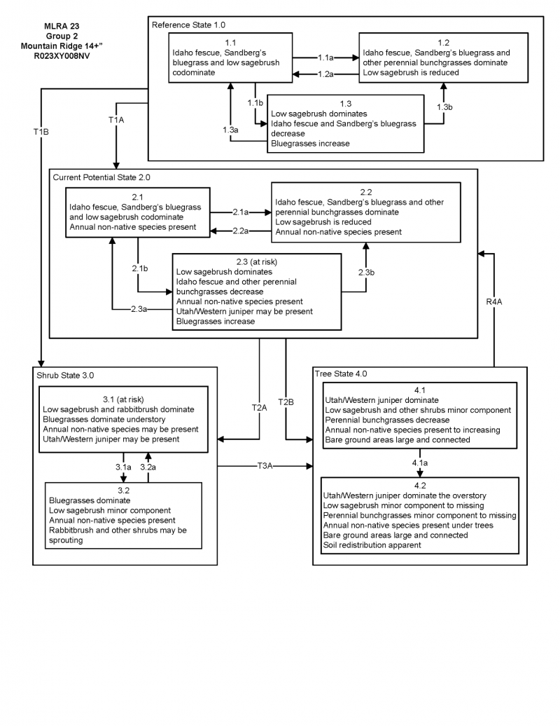
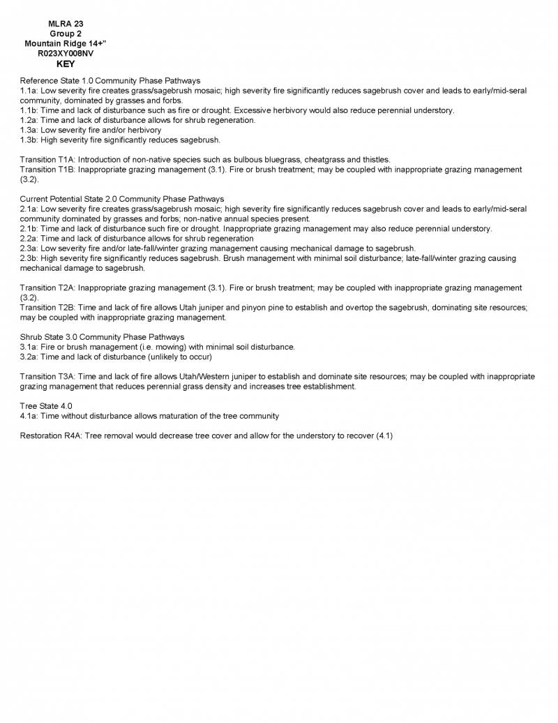
Click on box and path labels to scroll to the respective text.